This chapter provides a discussion of the main demographic changes, characteristics and causes in the OECD and in Korea. Comparisons and benchmarking are undertaken across OECD member countries using OECD standard indicators and the OECD Regional Database.
Adapting Regional Policy in Korea

1. Demographic trends in the OECD and Korea
Abstract
Introduction
Over the last 60 years, Korea has experienced one of the fastest economic growth rates in the OECD and a significant increase in income per capita and overall living standards. These benefits however have not spread evenly across the territory with gaps emerging in living standards in some areas and territories far away from large metropolitan areas. The national government has pursued development opportunities and well-being outside large cities through its recent national development plan to mitigate overconcentration of people and economic activity in its capital city and address population ageing and decline in localities and territories far from cities.
Recent OECD work at the sub-national level in Korea has already focused on related topics including decentralisation and rural-urban linkages (OECD, 2021[1]), rural well-being (OECD, 2020[2]), rural and regional development (Garcilazo et al., 2019[3]), housing and smart cities (OECD, 2018[4]), urban policy (OECD, 2017[5]), land use planning (OECD, 2017[6]), urban transport governance (OECD, 2017[7]) and road Infrastructure and development (OECD, 2016[8]).
This study follows-up on some policy areas and focuses on addressing region‑specific impacts of demographic changes. This global megatrend, along with digitalisation and climate change, will not affect countries uniformly but differ from region to region, thus calling for tailored made place-based policy responses that can adapt to varying regional conditions.
The overall study consists of three chapters. This first chapter focuses on demographic trends at regional scale for Korea, which depends both from natural evolution of population (e.g. migration, mortality, etc.) and economic performance of regions (e.g. to attract people) and provides a diagnosis of the performance and demographic dynamics of Korean regions as compared to OECD trends. The chapter first examines socio-economic trends in Korea focusing on growth, inequalities and territorial disparities. It also outlines the performance of Korean regions, examining trends in gross domestic product (GDP) per capita and productivity. The chapter then benchmarks demographic patterns in the OECD and Korea, focusing on population levels and elderly dependency ratios, and how these influence overall settlement structures. To draw international comparisons, this chapter makes use of the OECD regional typology, the OECD regional definition based on access to cities and the OECD functional urban areas definition (FUAs), as these apply a consistent definition across OECD countries.
Socio-economic trends in Korean regions
Korea has experienced strong growth, yet gaps remain in areas far from large cities
Korea's steady economic expansion over the past decades has made the country one of the most successful stories of productivity catch up in the OECD. The Korean economy, which has industrialised over time, has gradually specialised from agriculture to industry and then to services. These changes in specialization have been primarily responsible for the convergence of the country (OECD, 2021[1]). Recently, with more than USD 30,000 in per capita income, Korea's GDP per capita has grown from 6% of the OECD average in 1970 to 97% in 2019. Since the 2008 global financial crisis, GDP per capita in Korea has grown more than the OECD average thanks to a well-educated population and an innovative manufacturing sector (OECD, 2021[9]).
Despite over the last sixty years Korea has experienced strong economic growth, including in rural regions, some gaps remain in areas far from large cities and in places that have not benefitted from targeted development initiatives set up by the government. At the same time, growth has come with high pollution and resource consumption in Korea where high population density exacerbated environmental challenges (OECD, 2017[10]).
Figure 1.1 provides a snapshot of Korea in terms of economy, inequality and environment. When looking at all population groups, income inequality has remained stable and above the OECD average: between 2015 and 2017 the gap between the top and bottom 20% income earners increased from 6.9 to 7 in Korea, and from 4 to 5 in the OECD on average. Non-material well-being has improved in some areas. Life expectancy in Korea has increased by 20 years since 1970 (the second largest rise in the OECD). In 2010, life expectancy had already risen to 80.2 years, to reach 82.7 years in 2018, about 1.9 years above the OECD average. Nevertheless, poverty, despite a decline in recent years, remains above the OECD average, and is especially high among the elderly: with 45.7% of people above 65 living in relative poverty, being 12.9% the OECD average (OECD, 2021[9]).
Nowadays, in the context of the COVID-19 pandemic, effective measures to contain the spread of COVID-19 have limited the estimated fall in GDP to just over 1% in 2020, the smallest decline in the OECD. Global GDP was projected to contract by 4.2% in 2020 and grow by 4.2% in 2021 and 3.7% in 2022. Growth is expected to pick up to about 3% in 2021 and 2022 (OECD, 2020[11]). .
Figure 1.1. A snapshot of Korea
Korea’s economy is geographically concentrated in metro areas, but Korean rural regions have contributed much to national prosperity,
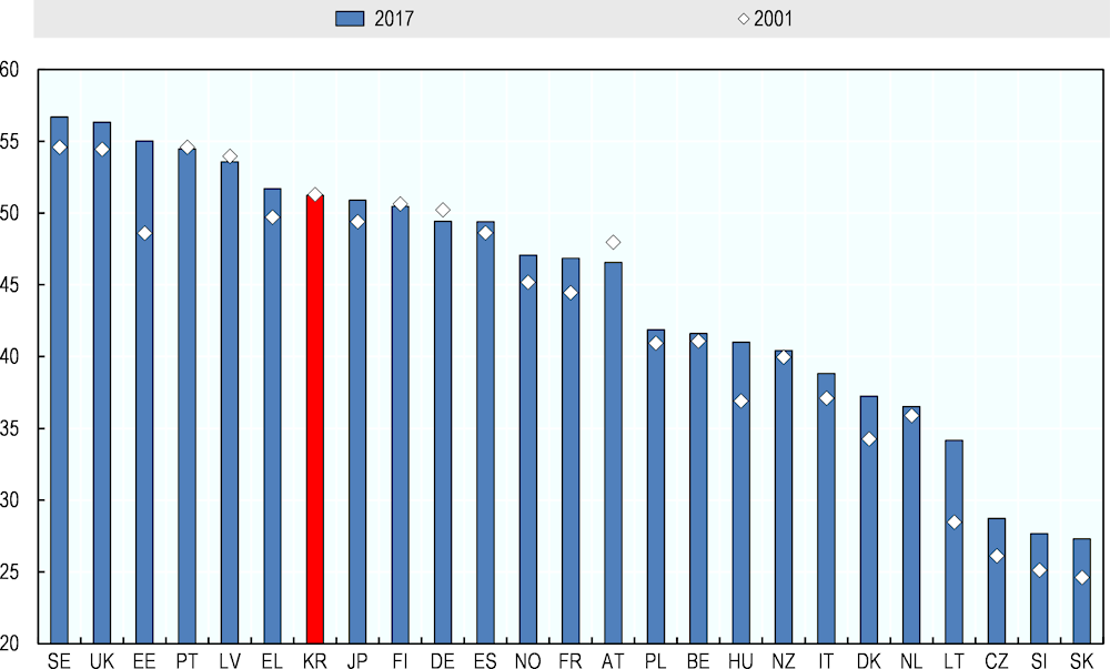
Korea’s economic geography has some characteristics in the OECD. The country is highly economically concentrated. In terms of geographic concentration of GDP, it ranks 7th in the OECD (Korea’s GDP concentration index was 51.2 in 2017). (Figure 1.2). In 2017, 45% of the whole country’s GDP was produced in just two large Metropolitan areas, namely, the capital Seoul and its region, Gyeonggi.
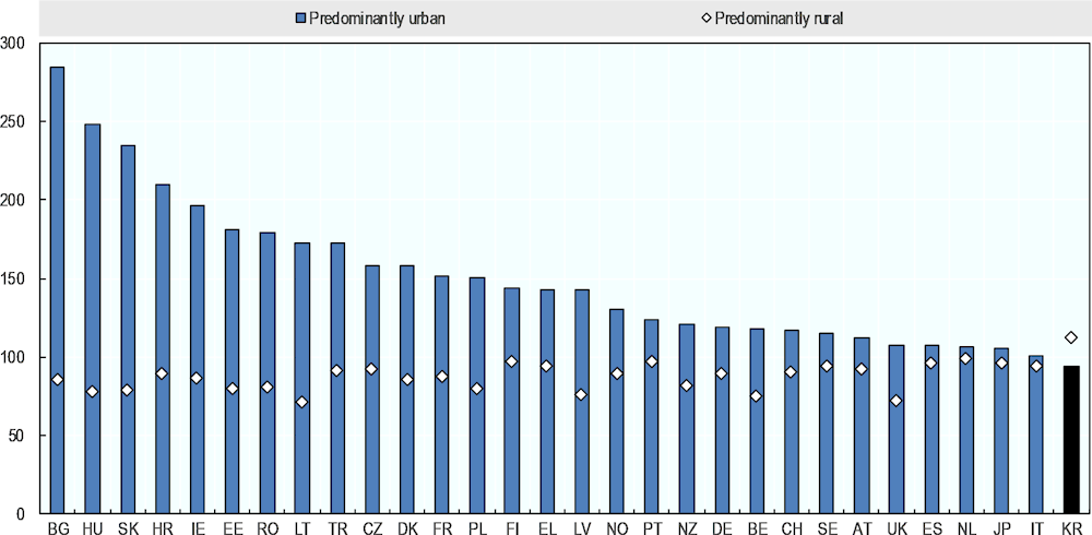
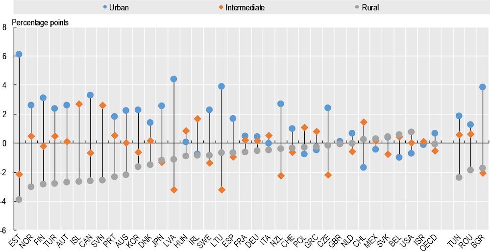
Moreover, exceptionally in the OECD, GDP per capita in urban areas is lower than GDP per capita in rural areas (Figure 1.3). In 2017 their GDP per capita was on average 13% higher than the national average. Korea is also the only OECD country where labour productivity in rural regions is higher than in urban regions (Figure 1.4) (OECD, 2021[1]). This may be also driven by the fact that, although Korean rural regions are less diversified than urban ones, they are highly specialised in tradable sectors, particularly in manufacturing, which is a key driver of regional competitiveness. Manufacturing alone contributes to over two-fifths of rural regions' GVA (OECD, 2021[1]).
However, manufacturing tends to concentrate in specific places within a given region, being often a result of a government’s policy intervention. For example, in Jeollanam-do, there is significant activity around the Gwangyang Bay Free Economic Zone, but less manufacturing activity elsewhere in the province. This means that the relatively high output of rural regions is not necessarily experienced by the whole region.
The strong performance of Korea’s rural regions may also result from the effects of geography and their close proximity to cities. In fact, residents and businesses can gain benefits from the surrounding agglomerations as they have a strong interaction with cities even in low density regions. In this respect, OECD research suggests that surrounding regions can “borrow” agglomeration from neighbouring cities (e.g. for a doubling of the population of a given city, the productivity of its urban areas may increase by 1%-1.5% within a radious of about 300 km) (OECD, 2021[1]).
Figure 1.2. Geographic concentration index of GDP (TL3 regions), 2017
Figure 1.3. GDP per capita gap between predominantly urban and rural regions, 2017
Figure 1.4. Labour productivity gab between urban and rural regions, 2016
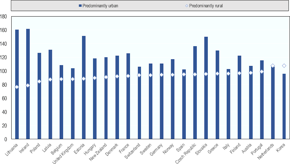
Note: Labour productivity as a ratio of GVA over workers per place of work.
Source: (OECD, 2021[1]). OECD, Regional Statistics (database), 2020.
Demographic distribution in the OECD and Korea
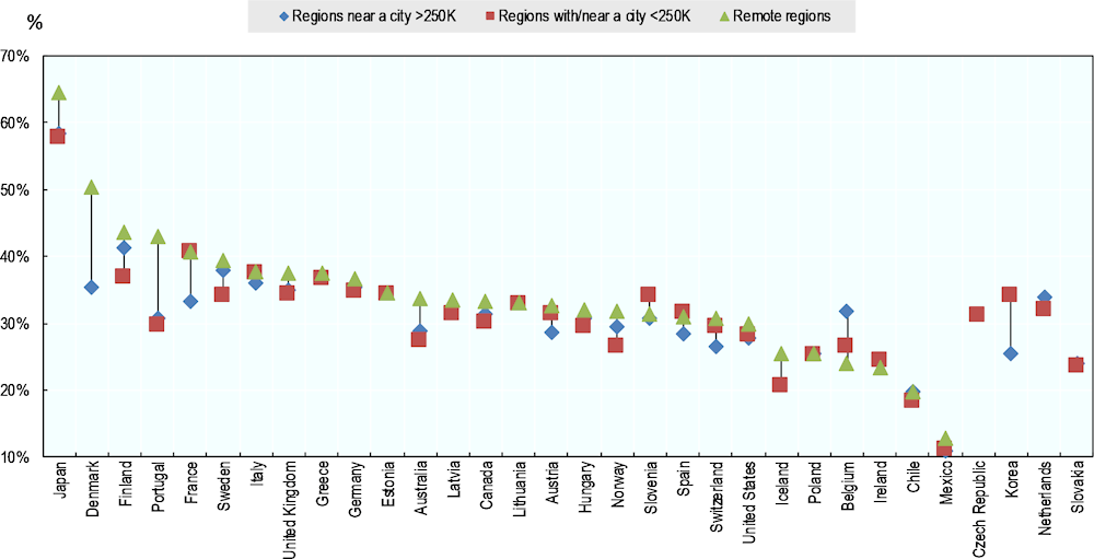
A relatively large share of the population lives in regions far from large cities in many OECD countries
According to the OECD regional typology (see Annex 1.A), 25% of the OECD population lived in predominantly rural regions in 2017, 20% of which lived in rural regions close to cities and 5% in rural-remote regions (Table 1.1). This means that 80% of the OECD rural population live in close proximity to cities and only 20% in remote regions (Figure 1.5). According to the alternative regional typology (see Annex 1.A), in 2019, 42% of the OECD population lived in regions with a large city, about 43.5% lived in regions near cities, and the remaining 14.5% lived in remote regions, which accounted 8% of the total population (Table 1.1). This evidence confirms that in OECD countries, only a small share of the total population lives in remote areas with no interaction to nearby cities. (OECD, 2020[2])
Table 1.1. Population shares by OECD regional typology based on access to cities
|
OECD regional typology |
OECD regional typology based on access to cities |
||
|---|---|---|---|
|
Predominantly urban regions |
48% |
Regions with a city >1M |
42% |
|
Intermediate regions |
27% |
Regions with a city >250K |
29% |
|
Predominantly rural regions |
25% |
Regions near a city >250K |
12% |
|
Close to cities regions |
20% |
Regions with/near a city <250K |
9% |
|
Remote |
5% |
Remote regions |
8% |
Note: City refers to a Functional Urban Area (FUA). Based on available data for 2 152 TL3 regions in 33 OECD countries. 2018 values for Australia, Ireland, Japan, and United States.
Source: (OECD, 2020[13]); OECD Regional Statistics (database) 2020.
Figure 1.5. Distribution of population and area by type of small regions (TL3), 2019
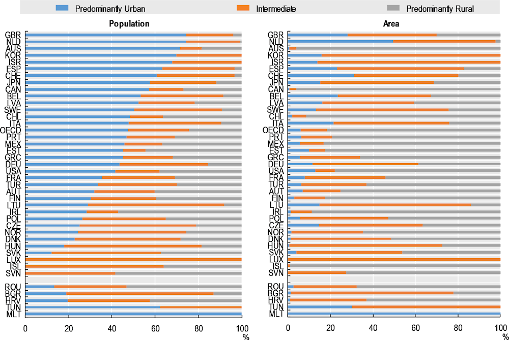
Note: Weighted averages of small regions (TL3). 2019 population or latest available year: TUN (2016); AUS, CAN, HRV, HUN, ISR, JPN, LTU, and USA (2018). Countries are ranked in descending order of the share of population in predominantly urban regions.
Source: (OECD, 2020[14]), OECD Regional statistics (database), 2020. Information on data for Israel: https://oe.cd/israel-disclaimer.
The distribution of the population of regions according to the alternative typology captures some similarities of countries according to their geographic characteristics (Figure 1.5):
Although only 8% of the OECD population live in remote regions, in 7 OECD countries one-fifth or more of the national population live in remote regions. These include Norway (31%), Finland (28%) and Sweden (24%) from Scandinavia with sparsely populated regions, Greece (31%) with an island and mountainous geography, and 2 of the largest OECD countries in terms of area, Canada (23%) and Australia (20%). (OECD, 2020[2]).
In fifteen OECD countries, more than 20% of the population live near or in regions with a small/medium city. Countries with the highest shares of population in these types of regions include Iceland (84%), and former East European and Baltic countries including the Slovak Republic (63%), Latvia (57%), the Czech Republic (43%), Hungary (36%), Estonia (34%) and Lithuania (33%). (OECD, 2020[2]).
About 20% of the population in the OECD live in regions near a large city. This percentage increases in 10 countries: Austria (21%), Belgium (50%), Denmark (30%), Germany (23%), Italy (22%), the Netherlands (25%), Portugal (20%), Slovenia (40%), Switzerland (40%) and the United Kingdom (22%). (OECD, 2020[2]).
Figure 1.6. A relatively large share of the population lives in regions far from large cities in many OECD countries. Population in 2019 (percentage)
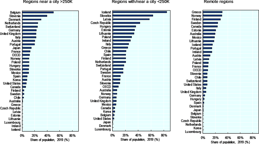
Note: City refers to an FUA. 2018 values for Australia, Ireland, Japan and the United States
Source: (OECD, 2020[13]); OECD Regional Statistics (database) 2020
Korea’s population is highly concentrated and urbanized
Korea has undergone quick demographic changes since the 1960s, when the country began its industrialization. The share of the rural population (national definition) decreased from 18.2 millions (60% of the total population out of 30.8 million) in the 1970s to only 9.7 million (19% out of 51.6 million) in 2018. Migration from rural to urban areas because of rapid industrialization have caused these trends (OECD, 2021[1]).
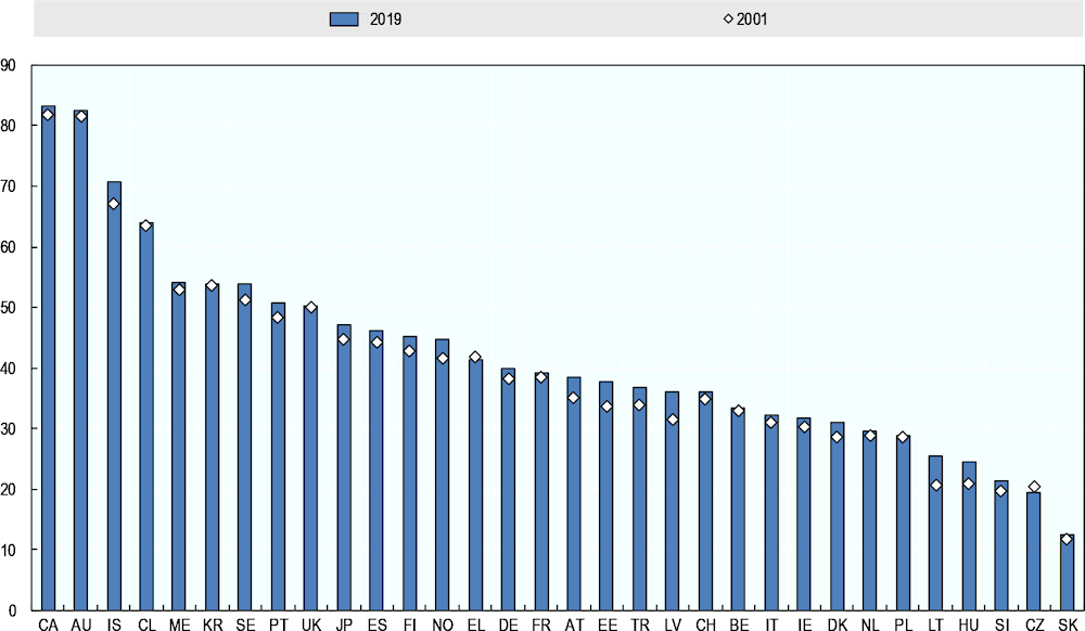
Even if the rate of concentration has declined in recent years, settlement patterns are concentrated in Korea when compared to OECD standards. In fact, among the 32 OECD countries for which data are available, Korea’s population was the 6th most concentrated across TL3 regions in 2019. The geographic concentration index depicts the spatial distribution of the population within Korea, comparing the resident population weight and the land area weight over all TL3 regions. The index ranges between 0 and 100: the higher its value, the larger the regional concentration. Korea’s population concentration index was 53.8 in 2019 (Figure 1.7).
Figure 1.7. Index of geographic concentration of population, TL3, 2001 and 2019
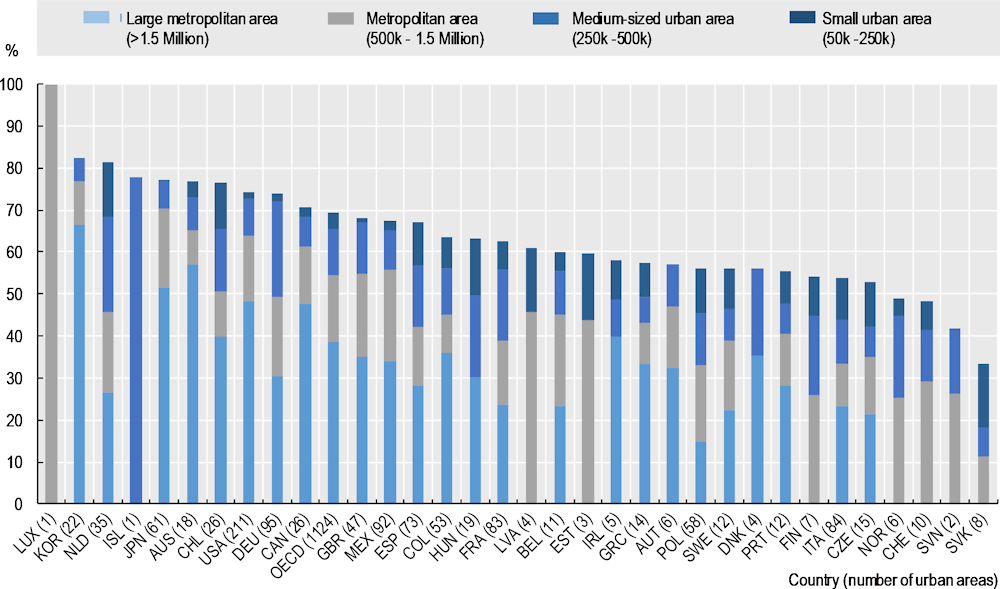
In term of the OECD FUA definition, 83% of Korean population lives in cities of more than 50 000 inhabitants and 76% lives in cities with more than 500 000 inhabitants, significantly higher than the OECD average share of 55%. When compared to OECD countries (Figure 1.8), only Luxembourg has a higher national share living in FUAs, making Korea one of the countries with the highest share of the national population living in FUAs (OECD, 2021[1]).
Figure 1.8. Population share living in Functional Urban Areas (FUAs) over total population, 2015
Korea’s population is also highly urbanised, in comparison with other OECD countries, approximately 17.1% of Koreans lived in rural regions in 2018, based on the OECD TL3 regional typology, or 11.3% if applying the OECD regional definition based on access to cities. The share of Korea’s national population living in rural regions (11.3%) is significantly lower than the OECD average (29%) (Table 1.2) and the majority of rural population have an easy access to a city (Figure 1.9). On average, the median travel time to the closest city is in Korea is about 25 minutes (the 4th shortest in the OECD). Of the 11.3% of the population who are rural dwellers, 7.8% lived in regions near a large city, while 3.4% lived in regions near a small/medium-sized city. There are no remote rural regions in Korea by the OECD definition. (OECD, 2021[1])
Table 1.2. Share of rural population according to different definitions, percentage, 2018
|
Share of rural population according to different definitions, 2018 |
||||
|---|---|---|---|---|
|
|
OECD |
Non-FUA |
Alternative OECD |
World Bank |
|
TL3 typology |
TL3 typology |
|||
|
Share of rural population |
17.10% |
17% |
11.30% |
18.50% |
Note: Table refers to year 2015 for FUA.
Source: (OECD, 2020[13]); OECD Regional Statistics (database) 2020. World Bank Rural Population (% of Population) - Korea (dataset), 2019 https://data.worldbank.org/indicator/SP.RUR.TOTL.ZS?locations=KP-KR.
Figure 1.9. Population share by TL3 regions, access to cities OECD definition, 2018
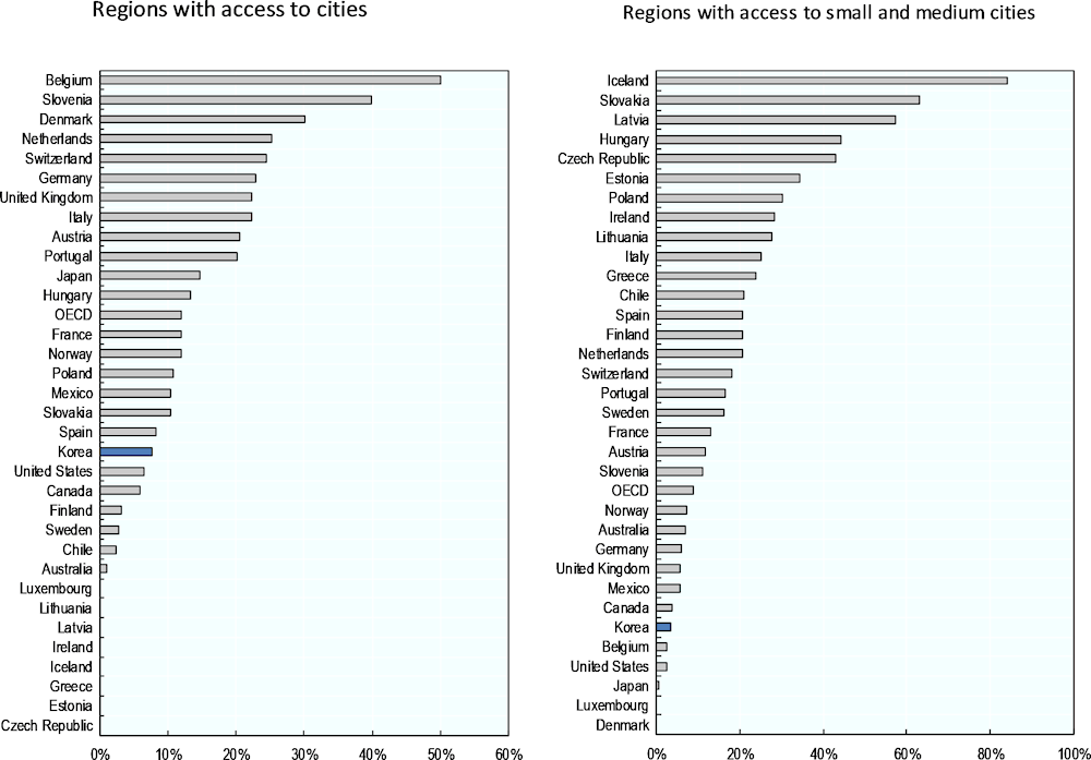
Note: 2017 values for Australia, Chile, Ireland, Japan and Mexico.
Source: (OECD, 2021[1]); OECD, Regional Statistics (database) 2020
Demographic dynamics in the OECD and Korea
The population grew in regions near large cities in most OECD countries in the last two decades
A common feature of cities is their ability to attract people and businesses. This happens as companies tend to locate themselves close to other companies and suppliers (for example for lower transport costs). Furthermore, businesses, especially service-oriented ones, tend to be located where there are greater densities of consumers. Workers also tend to be located close to businesses, due to the increased opportunities available. This dynamic is confirmed by demographic trends in the OECD over the past 20 years. Figure 1.10 shows that share of population living in metropolitan regions against the share of rural regions increased in all but three OECD countries (Greece, Korea and the Netherlands) (OECD, 2020[2]).
Figure 1.10. The share of the population in metropolitan regions increased in the last two decades
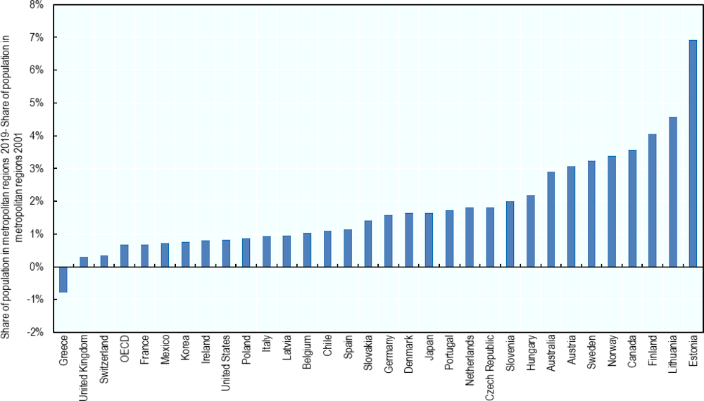
Note: Metropolitan regions includes regions with a city of at least 250 thousand inhabitants.
Source: (OECD, 2021[1]). OECD, Regional Statistics (database), 2020.
Most OECD countries (especially small ones like Estonia and Lithuania and those with large sparsely populated areas like Canada, Finland and Norway) concentrated even more population in metropolitan regions after the 2008 financial and economic crisis. In the period 2001-2019, the population in metropolitan regions grew by 0.70% per year, twice as fast as in rural regions (0.33%). Outside metropolitan regions, remote regions experienced the fastest growth rate (0.45%) and the second-largest absolute increase (7 million people) after regions near a large city (8 million) (Table 1.3). After the crisis, population growth slowed down in regions near a large city (by 13%) as well as in regions with a small/medium city (by 0.14%). (OECD, 2020[2]).
Table 1.3. Population growth slowed down in rural regions after the crisis
|
Region Type |
Change |
Growth rate |
Growth rate |
Growth rate |
|
|---|---|---|---|---|---|
|
(millions of people) |
2001-2019 |
2001-2007 |
2008-2019 |
||
|
Regions with a city >1M |
68 |
0.79% |
0.85% |
0.75% |
|
|
Regions with a city >250K |
34 |
0.57% |
0.63% |
0.52% |
|
|
Regions near a city >250K |
8 |
0.30% |
0.38% |
0.25% |
|
|
Regions with/near a city <250K |
5 |
0.28% |
0.35% |
0.21% |
|
|
Remote regions |
7 |
0.45% |
0.41% |
0.45% |
Note: City refers to a Functional Urban Area (FUA). Based on available data for 2 147 TL3 regions in 33 OECD countries.
Source: (OECD, 2020[13]); OECD Regional Statistics (database) 2020.
Although rural regions have experienced slower demographic growth than metropolitan regions, some 66% of them are increasing in population (Table 1.4). In the period 2001-20019, remote regions suffered most of the population decline (36% of them experienced a population decline of 1% or more) (OECD, 2020[2]).
Table 1.4. One-third of rural regions experienced population decline in the last two decades
|
|
Population growth |
Population decline |
|---|---|---|
|
Regions with a city >1M |
239 |
37 |
|
Regions with a city >250K |
416 |
110 |
|
Regions near a city >250K |
269 |
132 |
|
Regions with/near a city <250K |
214 |
116 |
|
Remote regions |
394 |
220 |
|
Total |
1532 |
615 |
Note: City refers to a Functional Urban Area (FUA). Based on available data for 33 OECD countries.
Source: (OECD, 2020[13]); OECD Regional Statistics (database) 2020.
In the period 2001-2019, metropolitan regions grew fastest in all 24 OECD countries that had at least one metropolitan region. On the other hand, population growth in remote regions was lower in 19 of the 28 countries with that type of region. In the same period, 50% of OECD countries with remote regions (14 out of 28) and almost 35% (9 out of 31) of countries with regions with or close to a small / medium city showed a decline in population (Figure 1.11). Japan, Hungary, Germany, Poland and Portugal showed a decline of population also in metropolitan regions (OECD, 2020[2]).
Figure 1.12 shows that in Europe, regions with or near a small / medium city are estimated to lose population in absolute terms by 2040 and beyond (compared to 2015, these regions will have lost almost 700,000 people by 2060, while metropolitan regions and regions close to cities will have gained about 22 million people). (OECD, 2020[2])
Figure 1.11. The population grew in regions near large cities in most countries in the last two decades
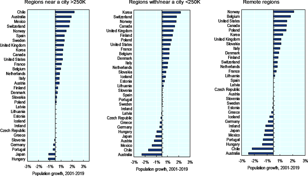
Note: City refers to an FUA. Based on available data for 2 147 TL3 regions.
Source: (OECD, 2020[2]); OECD Regional Statistics (database) 2020.
Figure 1.12. The population is projected to decline in all rural region types in European countries
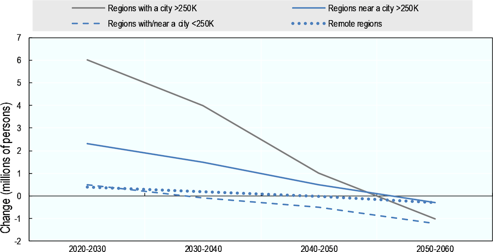
Note: Population series downscaled from country level to NUTS3 level, consistent with the 2018 EC Ageing Report, https://ec.europa.eu/info/sites/info/files/economy-finance/ip065_en.pdf.
Source: (OECD, 2020[2]); Batista e Silva, F. et al. 2016 Regionalisation of demographic and economic projections.
Migration patterns to metropolitan areas offer a partial explanation for the population decline in rural regions in Korea
In terms of population growth, according to the OECD TL3 regional typology, predominantly urban regions in Korea experienced the largest increase in their population share over the period 2001-17, increasing by 2.3 percentage points over this period (Figure 1.13). On the other hand, the share of population decreased both in the intermediate regions (by 0.6%) and in the rural ones (by 1.6%), while rural regions close to the big cities registered an annual increase in population of 0.48%. These population dynamics across different types of regions in Korea are in line with OECD trends (Figure 1.14). (OECD, 2021[1])
Figure 1.13. Change in the share of population by type of region (TL3), 2000-17
Figure 1.14. Population growth in TL3 non-metropolitan regions, 2000-18
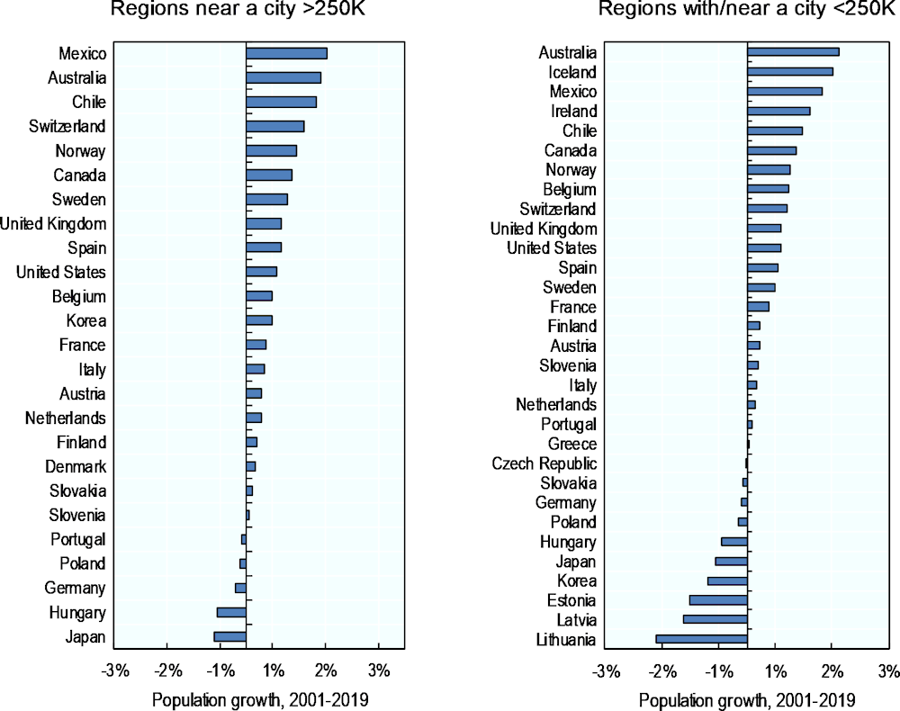
Note: City refers to a Functional Urban Area (FUA). Based on available data for 2 147 TL3 regions.
Source: (OECD, 2021[1]); (OECD, 2020[13]); OECD Regional Statistics (database) 2020.
The fall in rural population is driven mainly by a decline in Jeollanam-do, the only Korean TL3 region categorised as having access to small- and medium-sized cities (but which is relatively distant from a large city). Jeollanam-do’s population shrank annually by an average of 0.7% over the period.
Migration patterns offer one explanation for the population decline in rural regions in Korea: they show predominantly urban regions to be net migrants recipients from other typologies of regions. Based on the access to cities typology, not all Metropolitan regions are net recipients of migrants. In fact, the only type of region which saw a positive average of migration flows was that with access to a large city (Table 1.5). In 2017, regions with access to a large city recorded a positive average net migration rate, while other region types saw a negative average rate (OECD, 2021[1]).
Data also shows that young people, aged 15-29, disproportionally leave regions with access to a small/medium-sized city compared to other age groups. This age group is also particularly attracted to the country’s large metropolitan areas (OECD, 2021[1]).
The comparison of net migration rates of total population versus young people reveals that (OECD, 2020[2]):
large metropolitan regions attract young people (e.g. +0.95% of 15–29-year-olds in 2017);
regions near a large city attract older population (15-19 years old net migration is negative); and
compared to other age groups, young people disproportionally leave remote regions and regions with or near a small/medium city (-8.15%, 15–29-year-olds, 2017).
Table 1.5. Net migration rates, young and total population, by type of TL3 region (average), 2017
|
Net migration rates young and total population by type of TL3 region (average), 2017 |
|||
|---|---|---|---|
|
Net (young) migration rate defined as the median value of inflows minus outflows of (young) people over total population. |
|||
|
|
|
Net migration rate (%) |
Net migration rate (%), population 15-29 |
|
OECD TL3 regional typology |
Predominantly urban |
0.31 |
0.56 |
|
Predominantly rural |
-0.07 |
-1.24 |
|
|
OECD alternative typology |
Large metro |
-0.14 |
1.72 |
|
Metro |
-0.04 |
-4.92 |
|
|
Regions with access to large city |
1.42 |
0.95 |
|
|
Regions with access to a small/medium city |
-0.17 |
-8.15 |
|
Note: Net (young) migration rate is defined as the median value of inflows minus outflows of (young) people over the total population. Inflows are defined as the group of new residents in the region coming from another region of the same country; outflows are defined as the group of persons who left the region to reside in another region of the same country.
Source: (OECD, 2020[13]); OECD Regional Statistics (database) 2020.
Table 1.6. Net outflows of young people are larger in rural regions
|
Net (young) migration rate defined as the median value of inflows minus outflows of (young) people over total population. |
||
|---|---|---|
|
|
Net migration rate (%) |
Net migration rate (%), population 15-29 |
|
Regions with a city >1M |
0.07 |
0.028 |
|
Regions with a city >250K |
0.098 |
0.019 |
|
Regions near a city >250K |
0.128 |
-0.059 |
|
Regions with/near a city <250K |
-0.065 |
-0.085 |
|
Remote regions |
-0.058 |
-0.087 |
Note: Based on available information for 1 493 TL3 regions in 25 countries. Inflows defined as the group of new residents in the region coming from another region of the same country; outflows defined as the group of persons who left the region to reside in another region of the same country.
Source: (OECD, 2020[13]); OECD Regional Statistics (database) 2020.
Amongst FUAs, those with more than 500 000 inhabitants but less than 1.5 million experienced the fastest population growth with an approximately 18% overall increase over 2000-18. While metropolitan (9%) and medium-sized (7%) urban areas saw population growth, smaller urban areas decreased by 11%. In the period 2000-2015, commuting zones in functional urban areas (FUAs) of large metropolitan areas grew by 48%, while commuting zones of FUAs in medium-sized urban areas grew by 23%. Metropolitan (8%) and medium-sized (7%) areas, on the other hand, grow less. Population growth in metropolitan areas was higher at 17% (OECD, 2021[1]).
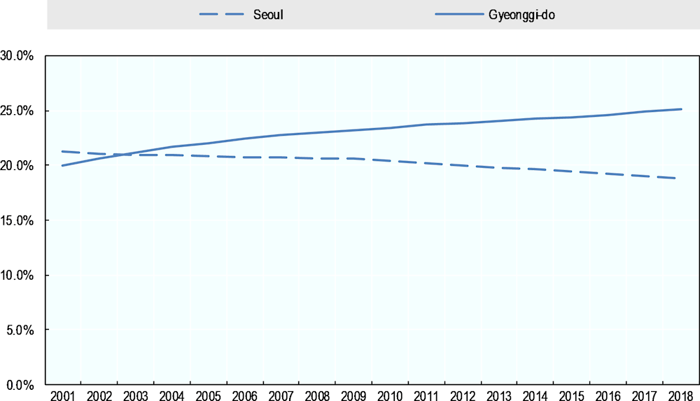
In 2001-2018, on a TL3 scale, Gyeonggi-do (20% in 2001) and Seoul (21.3%) concentrated the highest population shares within the TL2 capital region. Over this time, the population share in Seoul decreased to 18.8% in 2018, in contrast to Gyeonggi-do which experienced an increase to 25% (Figure 1.15) (OECD, 2021[1]).
Figure 1.15. Population shares in Seoul and Gyeonggi-do, 2001-18
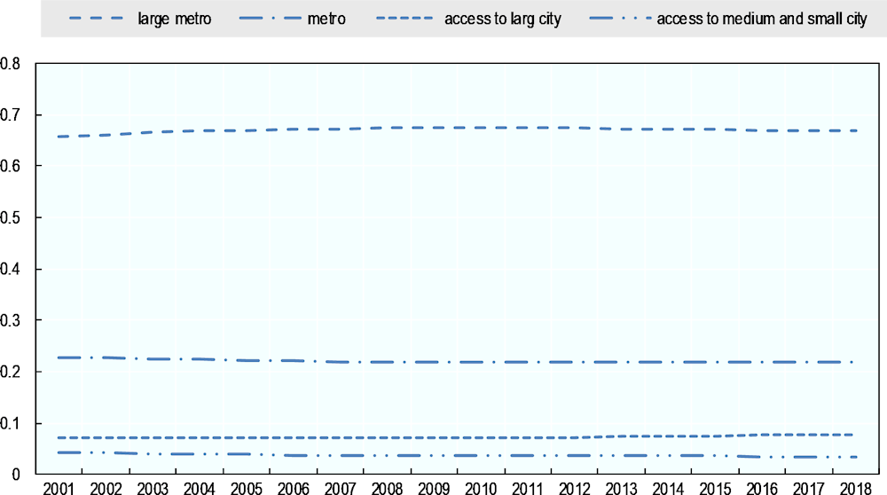
The definition of access to cities also offers different demographic trends between the types of regions. Metropolitan regions increased by 1% (from 65.7% to 66.8%), while the share of metropolitan regions decreased by 0.9 percentage points (from 22.7% to 21.9%). Regarding rural regions, those with access to large cities increased by 0.6% and regions close to small- and medium-sized cities decreased by 0.8% (Figure 1.16) (OECD, 2021[1]).
Figure 1.16. Population shares in Korean TL3 regions based on OECD access to cities definition
Population ageing and demographic change pose significant challenges for Korean regions and rural areas
As a result of longer life expectancy and low fertility rates, Korea is experiencing population ageing
As a result of longer life expectancy and low fertility rates, Korea is experiencing population ageing, which is predicted to continue in the long-term. Life expectancy increased of 20 years since 1970, the second largest increase in the OECD. In 2018, life expectancy was 82.7 years, 1.9 years above the OECD average, rising from 80.2 years in 2010 (OECD, 2021[9]). Since 2015 Korea is facing steadily low birth rates (0,84 children per woman in 2020) with a rapid decline (-31% new-borns in 2015-2019, -10% in 2019-2020; -26% total fertility rate in 2015-2019, -9% in 2019-2020) and it is projected to become an ultra-aged society by 2025, with the share of elderly exceeding 20% of the entire population (Statistics Korea, 2019[16]).
Demographic change in Korea is so fast that its total population is projected to change from the fourth youngest population in the OECD in 2012 to the third oldest one by 2050. (OECD, 2021[9]). The elderly dependency ratio (percentage ratio of over 65 years old and the 15-64-year-old population) is estimated to rise from 18% to 72% in 2014-50, which is the highest growth rate among all OECD countries. (OECD, 2021[9]), to rise even more sharply from to 120.2% by 2067 (Statistics Korea, 2019[16]).
Korea’s population is also decreasing
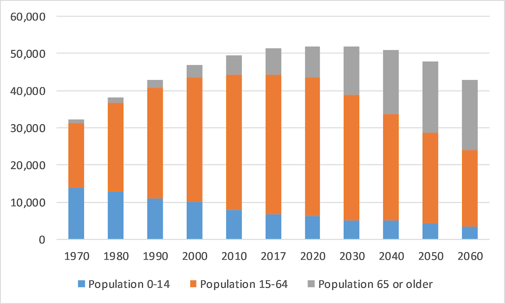
With a combination of declining births and a growing number of elderly, Korea reported the first natural decline in population in 2020. At this rate, Korea is projected to shed 12 million in the absolute population (current population 51 million) and 19 million in the working-age population from 2020 to 2067. (See also Figure 1.17 and Table 1.7). Male and female population is estimated to show a similar pattern of the entire population (Table 1.8). (Statistics Korea, 2019[16]).
In 2017, the working age population between 15 and 64 years of age accounted for 73.2% (37.57 million) of the total population, followed by the elderly aged 65 or older (13.8%, 7.07 million) and the youth aged 0-14 (13.1%, 6.72 million). 15-64 years old started to decline in 2017 and are expected to decrease from 37.57 million in 2017 to 17.84 million by 2067, or 45.4% of the estimated total population in 2067 (being the over 65 estimated at 46.5% and the 0-14 years old at 8.1%). In fact, with the elderly outnumbering the youth from 2017, the elderly will likely be 5.7 times more than the youth by 2067 (the elderly are estimated to double by 2033 and increase 2.6 times -to 18.27 million- by 2067, while the youth are projected to reduce to 3.18 million by 2067). (Statistics Korea, 2019[16]).
Figure 1.17. Korean population projection by age (million), 1970 - 2060
Source: (Statistics Korea, 2019[16]); Statistics Korea's special estimate of the future population between 2017 and 2067, March 2019
Table 1.7. Korean population projection by age, 1970 - 2060
|
|
1970 |
1980 |
1990 |
2000 |
2010 |
2017 |
2020 |
2030 |
2040 |
2050 |
2060 |
|
|---|---|---|---|---|---|---|---|---|---|---|---|---|
|
Ratio |
0-14 |
42.5 |
34.0 |
25.6 |
21.1 |
16.1 |
13.1 |
12.2 |
9.6 |
9.8 |
8.9 |
8.0 |
|
15-64 |
54.4 |
62.2 |
69.3 |
71.7 |
73.1 |
73.2 |
72.1 |
65.4 |
56.3 |
51.3 |
48.0 |
|
|
65 or older |
3.1 |
3.8 |
5.1 |
7.2 |
10.8 |
13.8 |
15.7 |
25.0 |
33.9 |
39.8 |
43.9 |
|
|
Total |
100.0 |
100.0 |
100.0 |
100.0 |
100.0 |
100.0 |
100.0 |
100.0 |
100.0 |
100.0 |
100.0 |
|
Source: (Statistics Korea, 2019[16]); Statistics Korea's special estimate of the future population between 2017 and 2067, March 2019.
Table 1.8. Korean population projection by gender, 1970 - 2060
|
|
1970 |
1980 |
1990 |
2000 |
2010 |
2017 |
2020 |
2030 |
2040 |
2050 |
2060 |
|---|---|---|---|---|---|---|---|---|---|---|---|
|
Total |
32,241 |
38,124 |
42,869 |
47,008 |
49,554 |
51,362 |
51,781 |
51,927 |
50,855 |
47,745 |
42,838 |
|
Male |
16,309 |
19,236 |
21,568 |
23,667 |
24,881 |
25,737 |
25,946 |
25,943 |
25,293 |
23,639 |
21,194 |
|
Female |
15,932 |
18,888 |
21,301 |
23,341 |
24,673 |
25,625 |
25,835 |
25,984 |
25,562 |
24,105 |
21,644 |
|
Gender ratio |
102.40 |
101.80 |
101.30 |
101.40 |
100.80 |
100.40 |
100.40 |
99.80 |
98.90 |
98.10 |
97.90 |
Note: Population unit (’000). The gender ratio is the number of men per 100 women (over 100 means more men than women, and vice versa).
Source: (Statistics Korea, 2019[16]); Statistics Korea's special estimate of the future population between 2017 and 2067, March 2019.
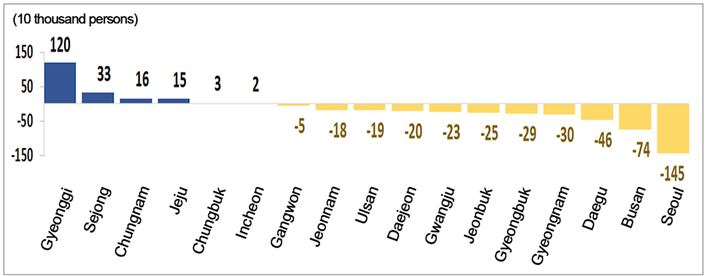
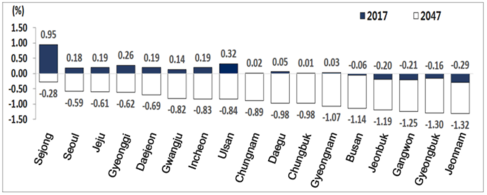
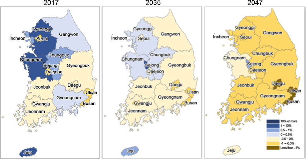
Over 2017-2047, the population is projected to decrease in 11 TL3 regions including Seoul and Busan, but it is estimated to increase in the remaining 6 TL3 regions (Gyeonggi, Sejong, Chungnam, Jeju, Chungbuk and Incheon) (Figure 1.18). In 2042, all regions including Sejong are expected to record natural decrease (Figure 1.19). After 2044, all TL3 regions (excluding Sejong) are estimated to have a negative population growth rate (Figure 1.20) (Statistics Korea, 2019[17]).
Figure 1.18. Change in the population by TL3 regions (2017-2047)
Note: Using the OECD typology defining TL3 regions, there are 17 such regions in Korea, which include special cities and metropolitan areas (Busan, Daegu, Daejeon, Gwangju, Incheon, Seoul, Ulsan) as well as provinces (Chungcheongbuk-do, Chungcheongnam-do, Gangwon-do, Gyeonggi-do, Gyeongsangnam-do, yeonsangbuk-do, Jeju-do, Jeollabuk-do, Jeollanam-do, Sejong),
Source: (Statistics Korea, 2019[17]); Population projection for Provinces (2017-2047).
Figure 1.19. Natural increase rate by TL3 regions (2017, 2047)
Note: Using the OECD typology defining TL3 regions, there are 17 such regions in Korea, which include special cities and metropolitan areas (Busan, Daegu, Daejeon, Gwangju, Incheon, Seoul, Ulsan) as well as provinces (Chungcheongbuk-do, Chungcheongnam-do, Gangwon-do, Gyeonggi-do, Gyeongsangnam-do, yeonsangbuk-do, Jeju-do, Jeollabuk-do, Jeollanam-do, Sejong),
Source: (Statistics Korea, 2019[17]); Population projection for Provinces (2017-2047)
Figure 1.20. Population growth rate by TL3 regions (2017, 2035, 2047)
Note: Using the OECD typology defining TL3 regions, there are 17 such regions in Korea, which include special cities and metropolitan areas (Busan, Daegu, Daejeon, Gwangju, Incheon, Seoul, Ulsan) as well as provinces (Chungcheongbuk-do, Chungcheongnam-do, Gangwon-do, Gyeonggi-do, Gyeongsangnam-do, yeonsangbuk-do, Jeju-do, Jeollabuk-do, Jeollanam-do, Sejong),
Source: (Statistics Korea, 2019[17]); Population projection for Provinces (2017-2047).
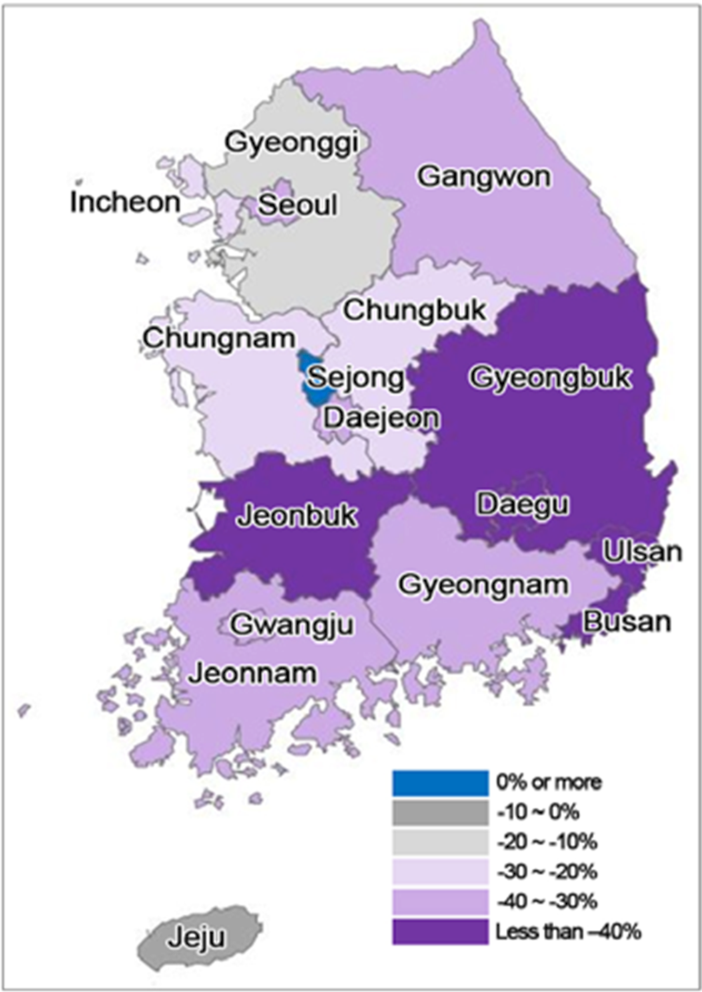
By 2047, the working age population is estimated to decrease in 16 provinces (excluding Sejong) compared to 2017. Busan (-45.6%) and Daegu (-43.4%) are projected to record the highest decreases in the working age population for the 2017-2047 period. Whereas Jeju (-7.4%) is projected to record the lowest decrease in the working age population for the same period. In 2047, the working age population of Sejong is projected to increase by 86.1% (160 thousand persons) compared to 2017. It is estimated that Jeonnam will reach the highest share of the elderly population aged 65 or over (with 46.8%) in 2047, followed by Gyeongbuk (45.4%) and Gangwon (45.0%). As for the share of the elderly population, all regions excluding Sejong (27.8%) are estimated to exceed 30%. In 2047, the young population of Sejong is projected to increase by 50.8% compared to 2017. Whereas the young population is projected to decrease by more than 30% in 13 provinces (excluding Jeju (-16.0%), Gyeonggi (-23.0%) and Chungnam (-25.8%)) for the 3 decades. (Figure 1.21) (Statistics Korea, 2019[17]).
Figure 1.21. Percent change in the working age population from 2017 to 2047
Note: Using the OECD typology defining TL3 regions, there are 17 such regions in Korea, which include special cities and metropolitan areas (Busan, Daegu, Daejeon, Gwangju, Incheon, Seoul, Ulsan) as well as provinces (Chungcheongbuk-do, Chungcheongnam-do, Gangwon-do, Gyeonggi-do, Gyeongsangnam-do, yeonsangbuk-do, Jeju-do, Jeollabuk-do, Jeollanam-do, Sejong),
Source: (Statistics Korea, 2019[17]); Population projection for Provinces (2017-2047)
Demographic pressures are growing particularly in rural regions close to small-/medium-sized cities
Over the last 18 years, the population living in Korea’s rural regions has become increasingly older, following the recent trends in OECD countries. Elderly dependency rates in Koreans rural regions stood at 27% in 2018. The ratio was slightly lower than the OECD average in TL3 rural regions (at 28.6%), but, when compared to urban, it is significantly higher and it is growing rapidly (about 4.2% annually in 2000-2018). In fact, the gap in the age dependency ratio between urban and rural regions in Korea is among the widest in the OECD, just behind Denmark and Japan: Korea, Australia, Canada, Finland, France, Japan, Sweden and the United Kingdom, all have a gap above 8 percentage points (Figure 1.22). (OECD, 2021[1])
These national figures, however, mask important regional variations. In Korea the share of the elderly population is higher in rural regions. Within rural regions, the elderly population grew faster in the region with access to a small/medium-sized city compared to regions with access to a Metropolitan region. In 2018, regions with access to a small/medium-sized city had the highest average elderly dependency ratios (33%), followed by regions with access to a Metropolitan region (24%). This differs from the trend typically seen in the OECD context, since in 2018, in 13 out of 18 OECD countries, the elderly dependency ratio was higher in regions with access to a Metropolitan region than in regions with access to a small/medium-sized city (Figure 1.22). (OECD, 2021[1]).
Figure 1.22. Elderly dependency ratio by country and type of non-metropolitan region, 2018
Conclusions
Despite over the last sixty years Korea has experienced strong economic growth, including in rural regions, some gaps remain in areas far from large cities and in places that have not benefitted from targeted development initiatives. The “penalty of distance” in rural economies can be quite substantial. In the OECD, the income level, productivity level and employment rate of regions near a large city are around 18%, 10% and 8% below OECD average levels respectively. The gaps for regions with or near a small/medium city are even bigger, at 28%, 20% and 14% below the OECD average, while the gap for remote regions is 21%, 14% and 3% below the OECD average (OECD, 2020[2]).
Korea’s economic geography has some characteristics in the OECD. The country is highly economically concentrated. In 2017, 45% of the whole country’s GDP was produced in just two large Metropolitan areas, namely, the capital Seoul and its region, Gyeonggi. Further, uniquely within the OECD, GDP per capita in Korea’s rural regions is higher than the GDP per capita in urban regions. The strong performance of Korea’s rural regions may also result from the effects of geography and their close proximity to cities. In this respect, OECD research suggests that surrounding regions can “borrow” agglomeration from neighbouring cities. (OECD, 2021[1]).
A relatively large share of the population lives in regions far from large cities in many OECD countries. On the other side, Korea’s population is highly concentrated and urbanized. The percentage of the population living in rural regions of Korea ranges from 11.3% to 18% according to the OECD regional type definition or the OECD access type to cities. Despite this low percentages, rural regions in Korea maintain strong linkages with cities, especially those bigger that 250,000 inhabitants (OECD, 2021[1]).
While many OECD countries are facing population decline in rural regions, metropolitan regions have been growing annually twice as fast as rural regions in the past two decades. Also, in Korea population is growing faster in metropolitan regions. In rural regions, population growth is higher in regions close to large cities and negative in those ones close to small- and medium-sized cities. Migration patterns offer one explanation for the population decline in rural regions in Korea. These trends point out that predominantly urban regions are net recipients of migrants from the other regions. Data also shows that young people, aged 15-29, disproportionally leave regions with access to a small/medium-sized city compared to other age groups. This age group is also particularly attracted to the country’s large metropolitan areas (OECD, 2021[1]).
As a result of longer life expectancy and low fertility rates, Korea is experiencing population ageing, which is estimated to continue in the long-term. Demographic change in Korea is so fast that its total population is projected to change from the fourth youngest population in the OECD in 2012 to the third oldest one by 2050. The elderly dependency ratio (percentage ratio of over 65 years old and the 15-64-year-old population) is estimated to rise from 18% to 72% in 2014-50, which is the highest growth rate among all OECD countries. (OECD, 2021[9]), to rise even more sharply to 120.2% by 2067. Korea’s population is also decreasing. With a combination of declining births and a growing number of elderly, Korea reported the first natural decline in population in 2020. Korea is projected to shed 12 million in the absolute population and 19 million in the working-age population from 2020 to 2067. Male and female population is estimated to show a similar pattern of the entire population (Statistics Korea, 2019[16]).
Elderly dependency ratio in Korean rural regions is slightly lower than other OECD rural regions but much higher if considered urban regions. In fact, Korea shows the seventh-highest gap in dependency ratios between rural and urban amongst OECD countries. Elderly dependency ratios are increasing at a fast pace in Korea’s rural regions in comparison to Metropolitan regions, particularly in regions close to small- and medium-sized cities (OECD, 2021[1]).
Population concentration, ageing and decline pose significant challenges for Korea. People are attracted to densely populated areas for the wider availability of job opportunities, goods and services. However, the benefit of average higher productivity and wages in densely populated areas must be weighed against the costs of agglomeration (or diseconomies of scale), including congestion, higher land and housing prices, rising inequality and environmental pressures (OECD, 2020[2]).
Demographic change on such a significant scale requires concerted policy action on several fronts to safeguard Korea’s economy and ensure social cohesion. Demographic changes in Korea call for new policy objectives that provide sustainable solutions to maintain a robust labour force, attractiveness and quality services in rural regions. Regardless of large agglomerations with great economic density, villages and smaller cities can act as very important aggregation and centres of development for the rural economy. Rural regions close to urban areas can also benefit from agglomeration and fewer diseconomies of scale. In other rural locations, however, demographic decline could be an inevitable trend due to structural factors. In these cases, rural and regional policies should not fight against demographic patterns but rather respond with strategic, sustainable forward-looking policies that support a vibrant community culture for people of all ages and mechanisms to integrate the elderly and young workers in the local economy (OECD, 2020[2]).
The following chapters focus, in particular, on what precisely is done and can be done to improve outcomes for Korea’s ageing workforce.
Annex 1.A. The OECD regional typology
The OECD regional typology simplifies regional data comparability across OECD countries. It classifies two levels of geographic units within each member country: i) large regions (TL2), which generally represent the first administrative tier of subnational government; and ii) small regions (TL3), which aggregate local administrative units (e.g. communes in France or municipalities in Mexico). TL3 regions are divided into predominantly urban (PU), intermediate (IN) and predominantly rural (PR) based on population density and size. Rural areas are further categorised into different types according to their proximity to urban centres for the purpose of defining specific challenges and opportunities related to their geographic location.
Using the OECD typology defining 3 types of TL3 regions (urban, intermediate and rural), there are 17 such regions in Korea, 9 of which are defined as PU, 3 as IN and 5 as PR. Of the five PR regions, all are further categorised as PR close to a city. There are no rural regions in Korea that are considered remote rural regions under the OECD typology.
The OECD uses the concept of functional urban areas (FUAs) as a complementary territorial definition (see Annex Box 1.A.1). FUAs define urban areas encompassing daily flows of people for work, leisure and social activities as functional socio-economic units, rather than relying on official administrative boundary definitions. Applying the FUA territorial definition, Korea has 22 FUAs covering 26% of the national territory. Out of the 22 FUAs, 5 are classified as large metropolitan areas (with a population of 1 500 000 or more) and 6 as metropolitan areas (with a population of 500 000 to 1 500 000), 8 as medium-sized urban areas (population between 250 000 to 500 000 people) and 3 as small urban areas (population between 50 000 and 250 000 people).
Annex Box 1.A.1. The EU-OECD definition of an FUA
The EU-OECD definition of FUAs consists of highly densely populated urban cores and adjacent municipalities (“commuting zones”) with high levels of commuting (travel-to-work flows) towards the cores. This definition overcomes previous limitations for international comparability linked to administrative boundaries. This methodology is a clear example of how geographic/morphological information from geographic sources and census data can be used together to get a better understanding of how urbanisation develops.
As the first step, the distribution of the population at a fine level of spatial disaggregation of 1 square kilometre (1 km2) is used to identify the urban cores, which are constituted by aggregations of contiguous municipalities that have more than 50% of their population living in high-density clusters. These clusters are made of contiguous 1 km2 grid cells with a population density of at least 1 500 inhabitants per km2 and a total population of at least 50 000 people.
As the second step, 2 urban cores are considered part of the same (polycentric) FUA if more than 15% of the population of any of the cores commute to work to the other core.
The third step defines commuting zones using the information on travel-to-work commuting flows from surrounding municipalities to the urban core. Municipalities sending 15% of their resident employed population or more to the urban core are included in the commuting zones, which thus can be defined as the “worker catchment area” of the urban labour market, outside the densely inhabited urban core.
The methodology makes it possible to compare FUAs of similar size across countries, proposing four types of FUAs according to population size:
Small urban areas, with a population of between 50 000 and 250 000 inhabitants.
Medium-sized urban areas, with a population of between 250 000 and 500 000.
Metropolitan areas, with a population of between 500 000 and 1.5 million.
Large metropolitan areas, with a population of 1.5 million or more.
The definition is currently applied to 34 OECD countries (of the 37 OECD members, it is not available for Israel, New Zealand and Turkey) and identifies 1 199 FUAs of different sizes. Among them, 351 FUAs have a population larger than 500 000 and 668 FUAs have a population larger than 250 000.
Source: OECD (2018[15]), OECD Regions and Cities at a Glance, https://dx.doi.org/10.1787/reg_cit_glance-2018-en.
An alternative regional typology based on access to cities
The two territorial definitions – the OECD TL3 Regional Typology and the complementary FUA territorial definition – lead to different analytic frameworks. The TL3 regions cover the entire territory within countries, while FUAs only capture a subsample of the territory. Furthermore, the OECD typology may lead to a certain dichotomy between urban and rural areas.
Against this backdrop, the OECD has recently developed an alternative definition introducing some spatial continuity between metropolitan and non-metropolitan areas. This definition of FUAs classifies cities and their broader area of influence based on commuting patterns. An FUA is constructed by concatenating grid cells with high population density (above 1 500 inhabitants per km2) into an urban core. Then, these cells are connected with surrounding lower density cells when the flows of commuting between the two types of cells exceed a given threshold (i.e. at least 15% of the labour force commutes to the urban core).
The alternative TL3 classification is based on the presence of FUAs within TL3 borders and the proximity of regions to FUAs of different sizes. The 5 types of regions include 2 types of metropolitan regions – large metropolitan (with an FUA of more than 1 million people) and metropolitan regions (with an FUA of more than 250 000 people). It also includes 3 types of non-metropolitan regions – regions near a large city (i.e. regions with access to an FUA of more than 250 000 people within a 60-minute drive), regions with a small/medium-sized city or near one (i.e. regions with an FUA of more than 250 000 people or with access to one within a 60-minute drive), and remote regions (see Annex Box 1.A.2for details).
Throughout the document, reference will be made to “rural regions” when referring to the group of non‑metropolitan regions, to a “large city” when referring to a city with more than 250 000 inhabitants and a “very large” city when referring to a city with more than 1 million inhabitants. Also, the terms “city” and FUA will be used interchangeably.
This alternative regional classification, based on access to cities allows measuring socio-economic differences between regions, across and within countries. It takes into consideration the presence of and access to FUAs. Access is defined in terms of the time needed to reach the most proximate urban area; a measure that takes into account not only geographical features but also the status of physical road infrastructure.
Annex Box 1.A.2. An alternative typology of small regions
The first tier adopts as a threshold 50% population of the TL3 (small) region living in an FUA of at least 250 000 people; the second tier uses as threshold 60 minutes’ driving time, a measure of the access to an FUA.
The new methodology classifies TL3 regions into metropolitan and non-metropolitan according to the following criteria:
Metropolitan TL3 region, if more than 50% of its population live in an FUA of at least 250 000 inhabitants. Metropolitan regions (MRs) are further classified into:
Large TL3 MRs, if more than 50% of its population lives in an FUA of at least 1.5 million inhabitants.
TL3 MRs, if the TL3 region is not a large MR and 50% of its population live in an FUA of at least 250 000 inhabitants.
Non-metropolitan TL3 region, if less than 50% of its population live in an FUA. Non-metropolitan regions (NMRs) are further classified according to their level of access to FUAs of different sizes:
With access to a TL3 MR, if more than 50% of its population lives within a 60-minute drive from a metropolitan area (an FUA with more than 250 000 people); or if the TL3 region contains more than 80% of the area of an FUA of at least 250 000 inhabitants.
With access to a small/medium-sized city TL3 region, if the TL3 region does not have access to a metropolitan area and 50% of its population has access to a small or medium-sized city (an FUA of more than 50 000 and less than 250 000 inhabitants) within a 60-minute drive; or if the TL3 region contains more than 80% of the area of a small- or medium-sized city.
Remote TL3 region, if the TL3 region is not classified as NMR-M or NMR-S, i.e. if 50% of its population does not have access to any FUA within a 60-minute drive.
Source: Fadic, M. et al. (2019[18]), “Classifying small (TL3) regions based on metropolitan population, low density and remoteness”, https://doi.org/10.1787/b902cc00-en.
These definitions, initially elaborated for international comparability, also represent important tools for policymaking purposes. The alternative regional definition is relevant for rural policies since it differentiates amongst different types of rural regions – those close to cities and those that are remote. Rural areas close to cities require a much stronger integration of policies with cities in areas such as transportation, land use labour market or housing amongst others. Furthermore, the definition differentiates rural areas with access to large cities vis-à-vis small/medium-sized ones allowing to better understand and capture differences in the linkages. In contrast, rural remote regions may require much-differentiated policy responses that address their particularities. Thus, spatial scales are critical tools for the design of regional policies.
For the case of Korea according to the alternative definition, seven regions are classified large MRs, six are classified as MRs, three (Chungcheongnam-do, Gangwon-do and Sejong Special Self-Governing City), as regions close to large cities and just one (Jeollanam-do) as a region close the small- and medium-sized cities.
References
[13] Fadic, M. et al. (2019), “Classifying small (TL3) regions based on metropolitan population, low density and remoteness”, OECD Regional Development Working Papers, No. 2019/06, OECD Publishing, Paris, https://doi.org/10.1787/b902cc00-en.
[3] Garcilazo, E. et al. (2019), “Rural study of Korea”, OECD Regional Development Working Papers, No. 2019/05, OECD Publishing, Paris, https://doi.org/10.1787/50e33932-en.
[9] OECD (2021), Inclusive Growth Review of Korea: Creating Opportunities for All, OECD Publishing, Paris, https://doi.org/10.1787/4f713390-en.
[1] OECD (2021), Perspectives on Decentralisation and Rural-Urban Linkages in Korea, OECD Rural Studies, OECD Publishing, Paris, https://doi.org/10.1787/a3c685a7-en.
[10] OECD (2020), OECD Economic Outlook, Volume 2020 Issue 2, OECD Publishing, Paris, https://dx.doi.org/10.1787/39a88ab1-en.
[2] OECD (2020), Rural Well-being, OECD, https://doi.org/10.1787/d25cef80-en.
[4] OECD (2018), Housing Dynamics in Korea: Building Inclusive and Smart Cities, OECD Publishing, Paris, https://doi.org/10.1787/9789264298880-en.
[12] OECD (2018), OECD Regions and Cities at a Glance, OECD Publishing, Paris, https://dx.doi.org/10.1787/reg_cit_glance-2018-en.
[5] OECD (2017), “Korea”, in National Urban Policy in OECD Countries, OECD Publishing, Paris, https://doi.org/10.1787/9789264271906-23-en.
[6] OECD (2017), “Korea”, in Land-use Planning Systems in the OECD: Country Fact Sheets, OECD Publishing, Paris, https://doi.org/10.1787/9789264268579-21-en.
[11] OECD (2017), OECD Environmental Performance Reviews: Korea 2017, OECD, http://dx.doi.org/10.1787/9789264268265-en.
[7] OECD (2017), Urban Transport Governance and Inclusive Development in Korea, OECD Publishing, Paris, https://doi.org/10.1787/9789264272637-en.
[8] OECD (2016), Road Infrastructure, Inclusive Development and Traffic Safety in Korea, OECD Publishing, Paris, https://doi.org/10.1787/9789264255517-en.

