The chapter provides an overview of the main economic, social and environmental trends in Colombian rural regions, setting the basis for policy recommendations in the following chapters. It first revises the classification of rurality in Colombia vis-à-vis the OECD territorial methodology. It then examines the national context under which rural development is taking place, and outlines the main economic and demographic patterns of Colombian rural regions. Finally, it analyses different drivers of well-being for rural regions.
Rural Policy Review of Colombia 2022
2. Strengths and challenges in the rural development of Colombia
Abstract
Key findings
Demographic
Colombia’s settlement patterns depict a polycentric structure. While most of Colombia’s population concentrates in metropolitan regions (57.9%), the country has a relatively high share of the population in rural regions (42.1%) in comparison to the average of OECD countries (29.6%).
Remote regions host most of the rural population in the country, followed by regions with/near a small/medium-sized city.
Unlike the trend in most OECD countries, Colombian rural regions are young, an asset that can be further mobilised.
Women are not fully inserted in the rural formal economy, missing a great asset to the country’s economy.
Economic
The economy has improved greatly over the last two decades, generating higher levels of development and reducing poverty during this period.
However, territorial inequality in income and other well-being factors remain high and have room for improvement to attain greater social cohesion. Risks of an economic slowdown in the short-term should not affect the effort to reduce territorial inequality.
The rural economy is increasingly diversified in terms of value-added and employment, shifting gradually from the high relevance of primary activities.
Nevertheless, agriculture is still the major employer for rural communities, but have low levels of productivity and face high labour and land informality.
Rural economies that are more diverse in their structure also register greater levels of competitiveness.
Therefore, attaining greater competitiveness of rural economies needs policies to boost agricultural productivity along with diversification efforts to increase income growth and strategies to improve land ownership, land and labour formalisation.
Lack of data at granular level and differentiating by typology (urban-rural) constrain the analysis relevant to evidence-based policy making.
Well-being enablers
Colombian infrastructure has been a pending issue to enable higher levels of rural and regional development, especially tertiary roads. Multimodality (e.g. deployment of the railway) can help improve connectivity.
The urban-rural gap in broadband connectivity and quality is among the largest in the OECD, which undermines accessibility to markets and services.
Low education attainment and high dropout remain high in rural areas, despite improvements in coverage.
Land informality is one of the major sources of instability in rural areas, reaching an average 52% of rural priorities.
Security levels have improved but rural communities still face violence and illegal activities, which deter investment and attractiveness of some rural areas.
Community network and quality of life are important assets of rural regions, as people in Colombia’s rural regions perceive greater social network support.
Trust in government is low and has declined over time in the country, which is reflected in a lower voter turnout relative to OECD countries and whistle-blowers reporting corruption.
Colombian rural regions are a source of relevant environmental assets and perform better than other OECD regions in terms of air pollution and production of clean energies. Yet, deforestation and low enforcement of waste and water management represent environmental risks. Likewise, rural communities are highly vulnerable to climate change.
Introduction
The chapter provides an overview of the main challenges and strengths of Colombian rural regions and outlines their economic, social and environmental trends vis-à-vis comparable Latin American and OECD countries. The chapter first revises the classification of rurality in Colombia vis-à-vis the OECD territorial methodology. It then examines the national context under which rural development is taking place. After this, the chapter outlines the main economic and demographic patterns of Colombian rural regions. Finally, it analyses different drivers of well-being for rural regions.
To enable a meaningful comparison of Colombian’s performance against a relevant benchmark, the analysis in the chapter makes use of two country groups, one based on comparable Latin American countries and the other composed of all OECD countries:
The Latin American countries are made up of the four Latin American economies: Argentina, Brazil, Chile and Mexico.
OECD country average: international comparability with the OECD’s 38 member countries has been established through a selection of indicators.
A territorial classification to better grasp the rural potential in Colombia
OECD countries have moved away from traditional definitions of rural as simply the remaining “leftover” space that is not urban, to delimitations of rurality that recognise different types of rural regions and thus help design policy responses best suited to their different challenges (OECD, 2020[1]).
Colombia’s official definition: A modern proposal not yet fully adopted
In 1997, Colombia developed a methodology that identified urban areas as the main territorial criteria while defining rural areas as the residual. At the time, a Land Management Plan was approved (Law 388 of 1997) to distinguish urban municipalities as the territorial units that had road infrastructure and primary energy, water and sanitation networks. Instead, it defined rural as the land that was not suitable for urban use or was used for agricultural, livestock, forestry, natural resource exploitation and similar activities.
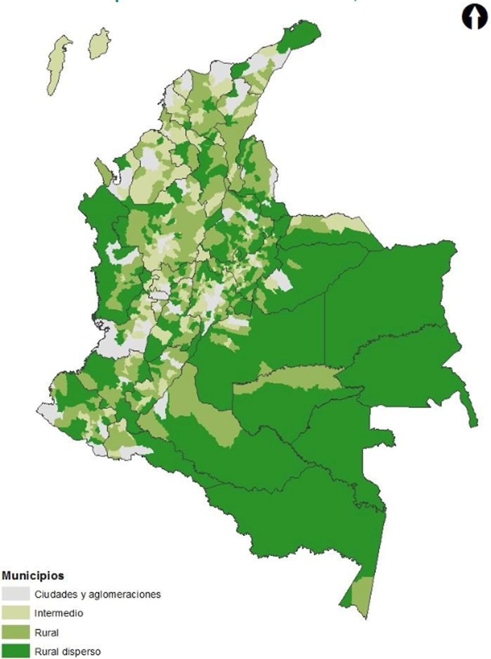
In 2014, an officially appointed commission of experts on rural development in Colombia (Mission for the Countryside) proposed a new territorial classification, which moved away from the urban-rural dichotomy and recognised different types of rural areas (DNP, 2014[2]) (Box 2.1). The suggested classification identifies four categories of municipalities, based on the size of the population, the population density and the proportion of the rural population, which was very much in line with OECD standards at the time (OECD, 2006[3]). The four territorial categories identified are: i) cities and agglomerations; ii) intermediate cities; iii) rural; and iv) dispersed rural. With this classification, the share of the rural population reached 30.4% in 2014, above the figure of 23.7% identified with the 1997 classification (Box 2.1). By 2014, the results revealed that 117 municipalities belonged to the category of “cities and agglomerations”, 314 to “intermediate cities”, 373 to “rural” and 318 to “dispersed rural”. Overall, this methodology improves on the previous one as it establishes a more differentiated view of rurality and adopts an urban-rural continuum.
Box 2.1. Rural definition proposed by the Mission for the Transformation of the Countryside
The Mission for the Transformation of the Countryside (hereinafter the Mission for the Countryside) was a national government initiative that aimed to elaborate a sound and broad portfolio of instruments and public policies for the development of Colombian rural communities within a timeframe of 20 years. The first step in this new set of public policies was to improve the rural definition used in the country to reflect the variety of rural areas and improve the identification of territorial interdependencies.
The Mission for the Countryside uses three main criteria to classify municipalities: i) municipalities within the System of Cities*; ii) population density; and iii) urban-rural population ratio (Figure 2.1). Based on this, municipalities are classified as follows:
Cities and agglomerations: Municipalities belonging to the System of Cities include: i) cities that present functional interconnectivity due to the daily commuting dynamics of the working population; ii) municipalities with a population equal to or greater than 100 000 inhabitants; iii) municipalities with less than 100 000 inhabitants in the municipal seat but with a strategic hierarchy at the sub-regional level; and iv) departmental capitals.
Intermediate cities: Municipalities that present any of the following characteristics: i) population in the municipal seat between 25 000 and 100 000 inhabitants, and with a population density equal to or greater than 10 inhabitants/km2; ii) population in the municipal seat of less than 25 000 inhabitants with a population density of 50 to 100 inhabitants/km2, and more than 70% of its population is located in the municipal seat; iii) population in the municipal seat of less than 25 000 inhabitants with a population density greater than or equal to 100 inhabitants/km2.
Rural: Municipalities that present any of the following characteristics: i) population in the municipal seat between 25 000 and 100 000 inhabitants, and with a population density of fewer than 10 inhabitants/km2; ii) population in the municipal seat of less than 25 000 inhabitants with a population density of 10 to 50 inhabitants/km2 and more than 70% of its population is located in the municipal seat; iii) population in the municipal seat of less than 25 000 inhabitants with a population density of 50 to 100 inhabitants/km2 and less than 70% of its population is located in the municipal seat.
Dispersed rural: Municipalities and non-municipalised areas that present any of the following characteristics: i) population in the municipal seat of less than 25 000 inhabitants with a population density of fewer than 10 inhabitants/km2; ii) population in the municipal seat of less than 25 000 inhabitants with a population density of 10 to 50 inhabitants/km2, and less than 70% of its population is located in the municipal seat.
Figure 2.1. Degree of rurality in Colombia according to the Mission for the Countryside
Note: * In 2014, the national government published the National Policy for the Consolidation of the System of Cities in Colombia, which aimed to guide urban development to support economic growth and competitiveness, and improve the quality of urbanisation to upgrade people’s well-being. The System of Cities is the third generation of national urban development policies since the 1998 Cities and Citizens policy and the 2004 “Guidelines to optimise urban development policy. For further information on the System of Cities, please visit: Misión para el Fortalecimiento del Sistema de Ciudades (DNP, 2020[4]).
Source: DNP (2014[2]), Misión para la Transformación del Campo, https://colaboracion.dnp.gov.co/CDT/Agriculturapecuarioforestal%20y%20pesca/Definicion%20Categor%C3%ADas%20de%20Ruralidad.pdf (accessed on 4 December 2021); OECD (2021[5]), “Colombian responses to OECD questionnaire on rural policy”, Unpublished, OECD, Paris.
Yet, the 2014 definition has not been fully integrated into national statistics nor across all sectoral policies. The National Department of Statistics (DANE) still relies on the 1997 definition for its statistical data collection process to classify between “rural land” and “urban land”. It mainly displays urban and rural statistics in two ways: urban as urban centres (cabeceras in Spanish) and rural as dispersed rural and populated centres (centros poblados y rural disperse in Spanish). According to this approach, the rural definition is based solely on qualitative criteria: those areas that are characterised by their dispersed disposition of houses and farms. For example, populated centres are defined as a concentration of at least 20 neighbouring or semi-detached houses located in the rural area of a municipality or a departmental township.
This approach leads to dichotomous territorial demographic and economic statistics that do not allow for differentiated trends among different types of rural areas or the recognition of different potential. For example, official statistics do not allow measuring the capacity of rural areas close to big cities to attract people and businesses. Equally important is the fact that this traditional definition is also embedded in certain policy plans, strategies and investment allocation (e.g. strategy to deploy broadband), which can lead to a homogeneous view on rural issues and policies for rural communities with different characteristics. Moreover, the existence of both types of rural definitions undermines consensus on what rurality represents across different levels of government and other stakeholders.
Colombia can thus benefit from homogenising its rural definition for policy and statistical uses. The 2014 methodology to define rurality sets a good basis for a definition to be adopted across all levels of government and standardise the way society and local actors refer to rurality. This definition could eventually be further finetuned by moving away from the qualitative and administrative criteria as the starting point of the definition (e.g. municipalities with regional relevance in the case of intermediate areas) and by including a sense of proximity, distance or accessibility (e.g. distance to cities).
The Colombian sub-regionalisation under functional criteria: A crucial step to identify territorial functionality
On top of the 2014 categorisation of the degree of rurality at the municipal level, in the framework of the National Development Plan 2018-2022, the National Planning Department (DNP) carried out a territorial division exercise based on regional functionality, in line with the OECD regional classification (Box 2.2). The development of this territorial definition under a functional criterion was pivotal in order to transcend administrative and political criteria and to deliver policies to municipalities that operate as functional regional units.
The result was 101 sub-regions, which serve as a basis for the development of statistics and analysis not only at the national level but now also at the international level, as they are covered by the regional development framework of the OECD and its 38 member countries. All in all, Colombia made significant progress in defining functional sub-regions (TL3), which set the ground for the categorisation of regions in terms of the degree of rurality and in line with the OECD Principles on Rural Policy adopted by member countries in 2019 (OECD, 2019[6]) (see Principle 2: Organise policies and governance at the relevant geographic scale in Chapter 3).
Box 2.2. Definition of functional sub-regions in Colombia
Subregionalisation of Colombia’s territory takes up the OECD Rural paradigm
The newly developed territorial approach of the DNP 2018-2022 takes up the OECD rural territorial classification paradigm, a commitment to thinking about the territory in a functional way beyond political-administrative boundaries, aligning the country with the OECD’s regional development approach.
To this end, a classification based on previous exercises (e.g. System of Cities and Functional Territories) was carried out to divide the country into sub-regions in such a way that functional criteria took precedence over administrative or political criteria. This territorial functionality is depicted through commutation flows and contiguity. Additionally, the notion of influence associated with the distance (time) between territories is introduced. This influence component is identified on the basis of: i) the urban population size of the municipality; as well as ii) the gross domestic product (GDP) (excluding mining); and iii) the number of enterprises in the municipality. Moreover, in order to strengthen the statistical component of the methodology, five workshops were held in different areas of the country with decision-makers, organisations and actors in the territory in order to validate the exercise and receive proposals for adjustments to the process described above.
This led to the definition of 101 sub-regions, which in several cases exceed political boundaries (only 30 sub-regions remain within a single department). In total, 93% of the sub-regions are made up of 9 sub-regions. The advantages described by the DNP include: i) potentiating territorial associativity and investment in regional projects on a supra-municipal scale, ii) connecting territories and taking advantage of economies of scale in the provision of public services and the concurrence of sources of investment; iii) improving the targeting of investments in public goods that generate spill-overs; iv) strengthening intermediate levels of multilevel governance; and v) generating internationally comparable information reports, which respond to the heterogeneity of the territory.
Source: RIMISP-DNP (2018[7]), Lineamientos conceptuales y metodológicos para la definición de una subregionalización funcional en Colombia, https://colaboracion.dnp.gov.co/CDT/Desarrollo%20Territorial/; CEPAL (2016[8]), Configuración territorial de las provincias de Colombia, http://www.dane.gov.co/files/censo2005/provincias/subregiones.pdf.
The OECD regional typology
Building on the efforts of territorial categorisation in Colombia, this review adopts the OECD regional classification (Territorial Level 2 [TL2] and Territorial Level 3 [TL3]) to better understand rural trends and facilitate regional comparability across OECD countries (Box 2.3). This classification identifies two levels of geographic units within OECD countries: i) large regions (TL2), which represent the first administrative tier of subnational government that in the case of Colombia is Departments (interchangeably referred to as regions in this review); and ii) small regions (TL3) that for Colombia is based on the efforts to build provinces or sub-regions (RIMISP-DNP, 2018[7]; CEPAL, 2016[8]; DANE, n.d.[9]). Both levels of regions encompass the entire national territory.
The OECD regional approach identifies the degree of rurality of regions based on density, population thresholds and their level of accessibility to cities (understood as Functional Urban Areas-FUAs). It then takes into account the relative location of rural places with respect to FUAs and introduces the idea of spatial continuity between urban and rural. TL3 regions cover the entire territory within countries, while FUAs only capture a sub-sample of the territory. This territorial methodology is used for the 38 member countries, allowing international comparability based on territorial functionality (presence of and access to FUAs) (Box 2.3). While this does not intend to replace Colombia’s 2014 definition or the recent definition of functional sub-regions, it can provide a classification of international comparability based on similar criteria with other OECD countries.
Box 2.3. OECD TL3 revised typology
The OECD regional database collects and publishes regional data at two different geographical levels, namely large regions (Territorial Level 2, TL2) and small regions (Territorial Level 3, TL3). Both levels encompass entire national territories. TL2 regions tend to represent the first administrative tier of subnational government (e.g. régions in France, estados in Mexico or states in the United States). TL3 regions are smaller territorial units that make up each TL2 region (e.g. départments in France or provinces in Spain). For the case of Colombia, TL3 are based on the definition of provinces (sub‑regions).
The OECD has adopted a new typology to classify administrative TL3 regions. This classification allows measuring socio-economic differences between regions, across and within countries. It is based on the presence and access to functional urban areas (FUAs), a concept defining cities and the urban hinterland, in other words urban economic agglomerations.
By controlling for these regional characteristics, the typology classifies TL3 regions into two groups, metropolitan and non-metropolitan. Within these two groups, five different types of TL3 regions are identified. Metropolitan regions (MRs) adopt as a threshold 50% population of the TL3 (small) region living in an FUA of at least 250 000 people; non-metropolitan regions (NMRs) use 60-minute driving time as a threshold, a measure of access to an FUA.
The methodology follows the criteria below:
Metropolitan TL3 region, if more than 50% of its population live in an FUA of at least 250 000 inhabitants. MRs are further classified into:
Large metro TL3 region, if more than 50% of its population live in an FUA of at least 1.5 million inhabitants. This region is labelled as a “region with a very large city” or “region with a city>1M”.
Metro TL3 region, if the TL3 region is not a large metro region and 50% of its population live in an FUA of at least 250 000 inhabitants. This region is labelled as a “region with a large city” or “region with a city>250k”.
Non-metropolitan TL3 region, if less than 50% of its population live in an FUA. NMRs are further classified according to their level of access to FUAs of different sizes into:
With access to (near) a metro TL3 region, if more than 50% of its population live within a 60‑minute drive from a metro (an FUA with more than 250 000 people); or if the TL3 region contains more than 80% of the area of an FUA of at least 250 000 inhabitants. This region is labelled as a “region near a large city” or “region near a city>250k”.
With access to (near) a small/medium city TL3 region, if the TL3 region does not have access to a metro; 50% of its population have access to a small or medium city (an FUA of more than 50 000 and less than 250 000 inhabitants) within a 60-minute drive; or if the TL3 region contains more than 80% of the area of a small or medium city. This region is labelled as “region with/near a small/medium size city” or “region with/near a city <250k”.
Remote TL3 region, if the TL3 region is not classified as NMR-M or NMR-S, i.e. if 50% of its population do not have access to an FUA within a 60-minute drive. This region is labelled as a “remote region”.
The procedure described leads to more statistical consistency and interpretable categories that emphasise urban-rural linkages and the role of market access. Throughout this report, reference will be made to “rural regions” when referring to the group of non-metropolitan regions
Source: OECD (2020[1]), Rural Well-being: Geography of Opportunities, https://doi.org/10.1787/d25cef80-en; Fadic, M. et al. (2019[10]), “Classifying small (TL3) regions based on metropolitan population, low density and remoteness”, , https://doi.org/10.1787/b902cc00-en.
Figure 2.2. OECD countries by share of the population in rural regions (TL3), 2021
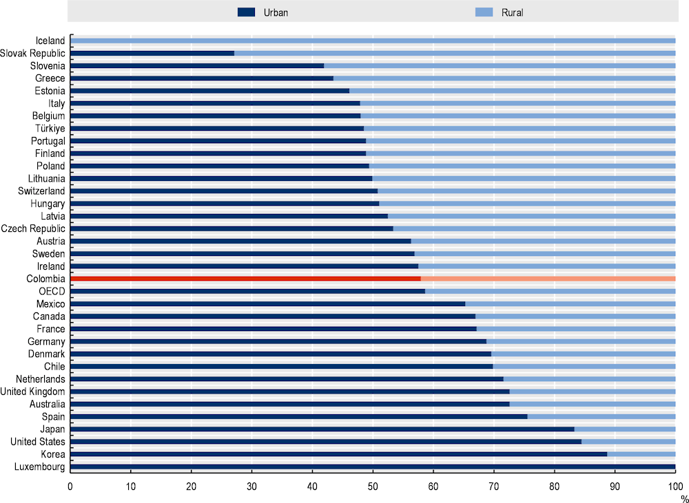
Note: The urban-rural population share has been calculated as the percentage of the population living in metro regions over the total population, rural as the share of the population in non-metro regions. OECD refers to the unweighted average.
Source: OECD (2022[11]), Regional Economy (database), https://stats.oecd.org/Index.aspx?DataSetCode=REGION_ECONOM# (accessed on 3 November 2021).
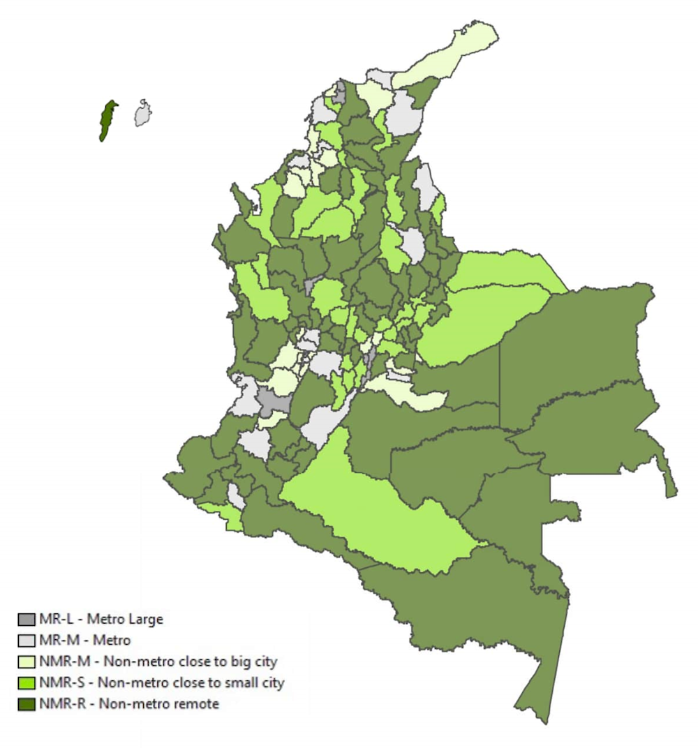
According to the OECD regional methodology, Colombia’s share of the population living in rural regions (42.1% by 2021) is slightly higher than the OECD average (41.4%) and other OECD Latin American countries (Chile, 30% and Mexico, 34.7%). This OECD methodology depicts a territorial classification that looks at rurality through an internationally comparable regional lens where Colombia is relatively more rural than territorial classifications with a municipal focus, such as the proposed 2014 rural definition (30.4%) and DANE’s statistical definition (24% by 2021). Nevertheless, when using territorial methodologies at a most granular level, Colombia remains a relatively high-urbanised country in international comparisons, as identified through other international and national definitions of urbanisation (OECD, 2022[12]).1
Most of the rural population in Colombia locates within remote rural regions (16.9%), almost twice the level of concentration in these types of regions across the OECD (8.9%). Regions with/near a small/medium size city concrete the second greatest share of the rural population (14.2%), also above the share of OECD rural population located in these types of regions. Table 2.1 shows a comparison between the OECD and Colombia of the share of the population living in each type of region.
Table 2.1. Distribution of regions (TL3) according to the degree of rurality, Colombia and OECD, 2021
Share of population per region (%)
|
Metropolitan regions |
Rural regions |
||||
|---|---|---|---|---|---|
|
Regions with a very large city |
Regions with a large city |
Regions near a large city |
Regions with/near a small/medium size city |
Remote regions |
|
|
Colombia |
36.26 |
21.68 |
10.88 |
14.24 |
16.94 |
|
OECD |
41.7 |
28.4 |
12.5 |
7.8 |
9.5 |
When looking at the administrative areas, 88% of municipalities are classified as rural, with an important share of municipalities in remote rural regions (51%). Table 2.2 shows the distribution of municipalities by the different types of regions according to the OECD typology explained:
Table 2.2. Municipalities of Colombia by OECD typology, 2021
|
|
Number of municipalities |
Share over total municipalities (%) |
|---|---|---|
|
Metro large |
36 |
3 |
|
Metro |
96 |
9 |
|
Non-metro close to a big city |
131 |
12 |
|
Non-metro close to a small city |
290 |
25 |
|
Non-metro remote |
569 |
51 |
Figure 2.3. Degree of Rurality in Colombia, according to OECD (TL3) regional classification
Source: OECD calculation based on the OECD TL3 regional methodology, OECD Regional Statistics https://www.oecd.org/regional/regional-statistics/.
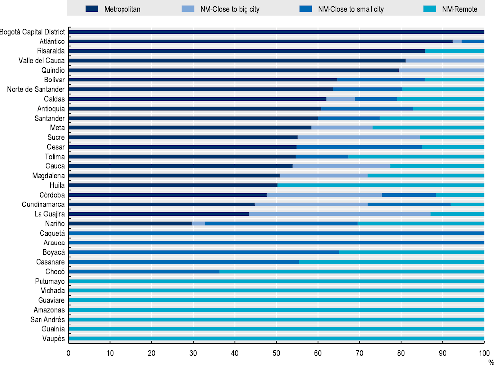
In Colombia, departments (TL2 regions) are the territorial level with the largest volume of information and data. Therefore, this report uses regional data (TL2) to identify some of the rural development trends in the country, when the information at the provincial (TL3) level is not available. To do so, this review classifies the degree of rurality of Colombian regions (TL2) according to the share of people living in rural TL3 regions (provinces) (Figure 2.4). The result displays a degree of rurality at the regional level from regions in which 100% of people live in rural provinces (e.g. Guainía, Vaupés) to regions like Bogotá where everyone is considered urban.
Figure 2.4. Share of the population by OECD regional typology in Colombia, 2021
Source: OECD territorial methodology with data from DANE (2022[13]), Departamentos y municipios de Colombia (database), https://www.datos.gov.co/Mapas-Nacionales/Departamentos-y-municipios-de-Colombia/xdk5-pm3f (accessed on 15 January 2022).
Setting the scene: The Colombian context
Colombia is a country located in the north-western part of South America, with a land surface area of 1 141 748 km², which makes it the 5th largest country across both Latin America and OECD countries. It borders in the east with Brazil and Venezuela, in the south with Ecuador and Peru, and in the west with Panama, and is the only South American country with coasts on the Pacific Ocean and the Caribbean Sea.
Colombia is the second most populated country in South America, reaching 51 million inhabitants in 2021, with 7.18 million inhabitants in its capital Bogotá (DANE, 2022[13]). The 1991 Constitution establishes Colombia as a unitary and decentralised republic that is divided administratively and politically into 33 divisions: 32 departments (TL2 regions), which are governed from their respective capital cities, and a capital district, Bogotá (also included as TL2 region in this report). Colombia is a highly concentrated country, both demographically and economically.
The country has a unique diversity, ranking as the 3rd most biodiverse country in the world (15% of the world’s total) thanks to its great variety of climatic areas. Colombia’s thermal floors are: paramo, cold, temperate and warm, which in addition to their particular climate, are also characterised by the fact that each thermal floor is home to unique species and agricultural production. Colombia has one of the most representative ethnic presences in South America. Amerindians, African immigrants and Hispanic immigrants from the colonial era are the predecessors of the 5 recognised ethnic groups: Indigenous (4.4% of the national population), Afro-Colombians (6.7%), Raizal (in San Andrés and Providence and Santa Catalina Islands, 0.05%), Palenquero (mainly located in the municipality of San Basilio de Palenque, 0.01%) and gypsy (0.0006%) populations inhabit the territory and make up Colombia’s ethnic diversity (DANE, 2018[14]; Ministry of Health and Social Protection, 2020[15]).
Colombia’s economy is the fourth largest in Latin America in terms of GDP (World Bank, 2020[16]), after Brazil, Mexico and Argentina. It stands out in the international scene for the significant growth it has experienced in the last decade in the export of goods and for the attractiveness it offers to foreign investment and tourism. Its economy is heavily based on services at 64.2% (vs. 71.4% OECD average), followed by industry, including construction, at 28.8% (26.0% OECD average) and agriculture, at 7.1% (2.6% OECD average) (OECD, 2022[17]). Colombia’s main exports are mineral fuels, lubricants and related materials representing 54.1% of the total, followed by food and live animals at 13.2%. Its net trade balance is negative, as exports represent 15.9% of the Colombian economy while imports amount to 21.7%.
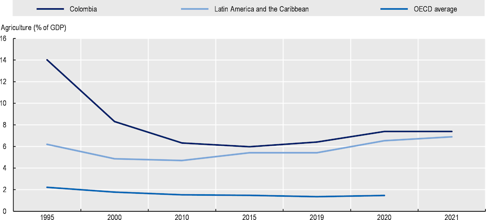
Agriculture is gradually reducing its weight in the national and rural economy. Despite still employing most rural workers (62%), the sector’s share of national GDP declined by more than half over the past decades, from 14% in 1995 to 6% in 2020. The diversity of the country’s climatic soils makes Colombia one of the world’s top 5 producers of coffee, avocado and palm oil and one of the world’s top 10 producers of sugar cane, banana, pineapple and cocoa.
Colombia has steadily strengthened its economy over the last two decades
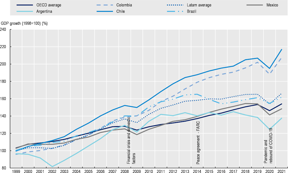
Over the last two decades, Colombia enjoyed remarkable economic stability and growth (Figure 2.5). Indeed, Colombia’s GDP growth rate averaged 3.8% per year during that period, which was coupled by a declined in the unemployment rate (from 15.1% in 2001 to 13.4% in 2021). Even so, deep structural problems remain in the labour market, such as high informality, where women and youth were particularly affected not only during the pandemic but also since the 2008 crisis.
Figure 2.5. GDP growth in Colombia, Latin America and OECD, 1998-2021
Note: GDP, purchasing power parities (PPP) (constant 2017, in USD).
Source: Own elaboration with data from World Bank (2021[18])), Database, https://data.worldbank.org/indicator/ (accessed on 2 November 2021).
After the global financial crisis and until the health crisis that led to an economic crisis in the wake of the COVID-19 pandemic in 2020, Colombia’s economy grew solidly, above many Latin American countries such as Brazil, Chile or Mexico. Colombia experienced a 39.1% increase in its economy between 2012 and 2019 (the OECD average was 21.3%), which was then hit hard by the arrival of COVID-19 with a 6.8% drop in GDP (4.9% in the OECD). Colombia’s economy surpassed the pre-crisis level in the third quarter of 2021 and GDP is projected to grow by 5.5% in 2022 and 3.1% in 2023. Private consumption is the main driver of the recovery as employment picks up, although at a slower pace than economic activity (OECD, 2022[19]).
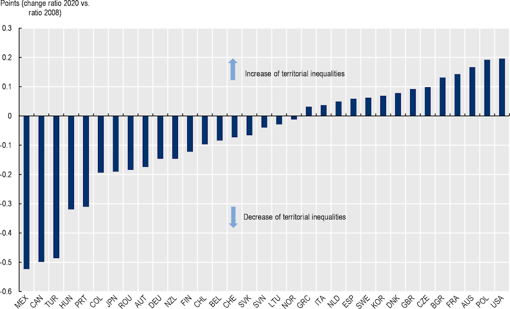
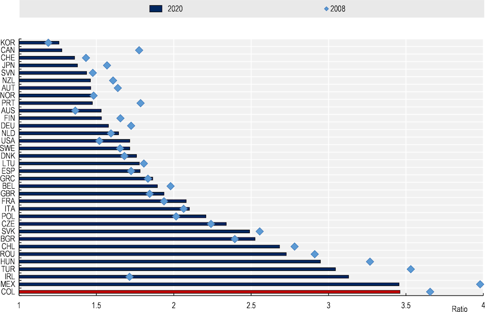
The economic growth after the 2008 crisis has come with a reduction of regional inequalities. In a country with an important historic income gap between the richest regions and poorest ones, reducing inequalities is an important objective to improving well-being and social cohesion in the country. During 2008 and 2018, Colombia was the sixth OECD country that registered the greatest drop in regional income inequality (measured as the ratio of the top 20% richest region over the bottom 20% poorest region) (Figure 2.6). This closing of the gap was associated with the greater growth of regions dependent on natural resources, which took advantage of the higher prices of commodities in the post-crisis period.
Figure 2.6. Change in regional (TL2) income inequalities, 2008 vs. 2020
The demographic concentration has increased with the flow of regional migrations towards medium-sized cities. Whereas, the country’s economy has been deconcentrated through the convergence of its regions. This has important implications and is a relatively positive starting point for capitalising on pockets of growth in these medium-sized cities. Moreover, it has the potential for spreading to the surrounding rural regions and clustering some of the growth of these economic clusters, more delocalised from large cities than is common in OECD countries.
Yet, regional inequality remains high, with room for improvement
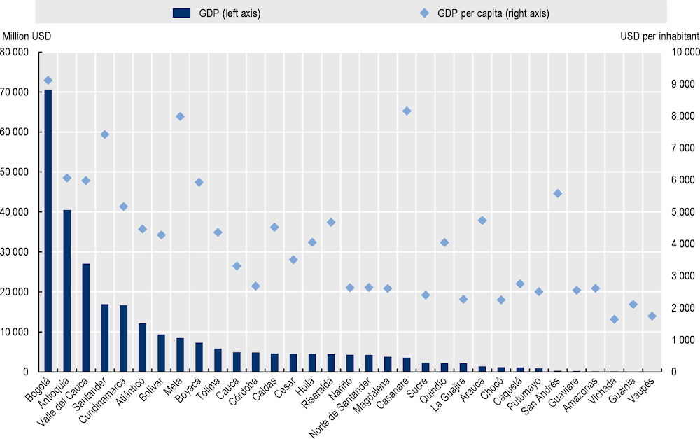
Despite the progress in closing the regional gap in the last decades, Colombian remains the OECD country with the highest income gap between the richest and poorest regions (Figure 2.7). This territorial inequality in Colombia translates into an urban-rural regional gap, where Bogotá has almost five times the GDP per capita of a rural region like Vaupés (Figure 2.8).
Thus, the last two decades of sustained growth have not been evenly spread across the territory and have involved rapid growth in urbanisation. This was the result of massive migration flows from rural to urban areas since the late 1930s (Camargo et al., 2020[20]), partly due to the effects of violence that affected rural areas more. As in most OECD countries, agglomeration economies tend to achieve larger economies of scale, with higher sectoral productivity that allows higher wages than those located in less densely populated regions (OECD, 2020[1]). The regions with the lowest GDP per capita in the country coincide with those that rank as the most rural, e.g. Vaupés and Vichada are the two regions with the lowest economic level (DANE, 2022[21]). As in other OECD countries, rural regions that register the highest GDP per capita are resource-rich regions; in Colombia, these regions specialise in fossil fuels (e.g. Casanare, Meta).
Figure 2.7. Regional disparity in GDP per capita, OECD countries, 2008-20
Note: The GDP per capita of the top and bottom 20% regions are defined as those with the highest/lowest GDP per capita until the equivalent of 20% of the national population is reached. Based on GDP per capita values expressed at 2015 constant prices, using OECD country deflators and converted into constant USD PPPs, 2015 reference year. TL2 regions in Colombia are departments
Source: OECD (2022[11]), Regional Economy (database), https://stats.oecd.org/Index.aspx?DataSetCode=REGION_ECONOM# (accessed on 3 November 2021).
Figure 2.8. GDP and GDP per capita by department in Colombia, 2021
Note: GDP at current prices 2020.
Source: OECD (2022[17]), OECD Economic Surveys: Colombia 2022, https://doi.org/10.1787/04bf9377-en; DANE (2022[13]), Departamentos y municipios de Colombia (database), https://www.datos.gov.co/Mapas-Nacionales/Departamentos-y-municipios-de-Colombia/xdk5-pm3f (accessed on 15 January 2022).
Inequalities are not solely monetary but affect a wide range of multidimensional factors that together dictate the degree of well-being of the population. Thus, such urban-rural regional disparities also reflect in well‑being inequalities, including educational outcomes, access to digital connectivity labour and land informality and security, among others (see section on well-being enablers). Effective access to quality services also lags behind urban areas, with rural areas facing lower education attainment and healthcare coverage (Chapter 4), poorer quality and accessibility to transport and water infrastructure as well as lower broadband connectivity. Ultimately, the socio-economic disparities across the country become a more complex task where inequality affects access to enabling development factors, beyond just monetary inequality.
Moreover, Colombia ranks as one of the OECD and Latin American countries where a low-income citizen requires more time to reach the national median income, 11 generations, which is 2 more generations than in Brazil (9 generations), 3 more than Chile (6) and 5 more than Argentina (6), and far above OECD average (4.5) (OECD, 2018[22]). Nevertheless, Colombia’s reform of the General System of Royalties (2011-12) has helped reduced regional inequalities (OECD, 2017[23]) and its most recent reform in 2020 should help accelerate the investment in the poorest regions and reduce regional economic disparities over time.
Despite the economic performance of the last decades, the growing risks of a global economic slowdown in the short term, due to tighter financial conditions and inflationary pressures, would impact Colombia's economic growth. Therefore, policy must ensure that the economic slowdown does not translate into greater territorial inequality in the country.
The population in Colombia has concentrated at a faster pace than its economy
Colombia has experienced a territorial concentration of its population in the last decade and ranks as one of the most demographically concentrated countries in the OECD (Figure 2.9). In addition to the rapid urbanisation trend in Colombia, the country’s geography, based on the presence of extensive forests like the Amazon, desert land and mountainous terrain, has led to a concentration of settlement patterns in a few geographic areas. In 2019, the country registers the fifth greatest territorial concentration after Canada, Australia, Israel and Chile.
Unlike many Latin American countries, such concentration has not occurred in one single large metropolitan region (above half a million inhabitants) but across different medium/small FUAs, which reveals the polycentric structure of the country (OECD, 2022[12]). This distribution of settlement patterns highly concentrated around specific urban zones (Colombia has a classified system of 18 cities) could be mobilised as an opportunity to unlock urban-rural synergies around pockets of growth.
While a large structure of small cities could in principle bring challenges in terms of achieving economies of scale across all of them, it can also bring benefits to unlock development poles based on synergies with surrounding rural areas. Mobilising these opportunities implies particular strong co‑ordination, locally across the municipalities but also with national policies (this would be discussed in the next chapters of this review) (OECD, 2021[24]).
Figure 2.9. Geographic concentration index of the population in OECD countries, 2001 and 2019
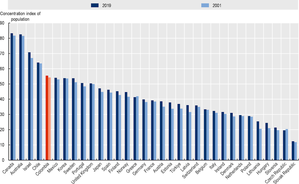
Note: The geographic concentration index depicts the spatial distribution of the population within Colombia, comparing the resident population share and the land area weight over all TL2 regions. The index ranges between 0 and 100: the higher its value, the larger the regional concentration. The geographic concentration index of population, which is comparable across countries, is calculated as: , where is the population share of region i, is the area share of region i. Calculated with TL2 regions.
Source: Own elaboration with data from OECD (2022[11]), Regional Economy (database), https://stats.oecd.org/Index.aspx?DataSetCode=REGION_ECONOM# (accessed on 3 November 2021).
Moreover, the analyses on the evolution of geographical concentration reveal a relatively lower concentration of economic activities than people (Figure 2.10). It might be indicative of the relevant role of extractive industries in the economy, which concentrates high value in a few regions that have a low share of the population (e.g. Casanare). Such areas of economic activity can be further mobilised with particular policies to create more diversified economies with greater linkages to urban regions.
Figure 2.10. Concentration index change of population and economy at the TL2 level in Colombia, 2004-20
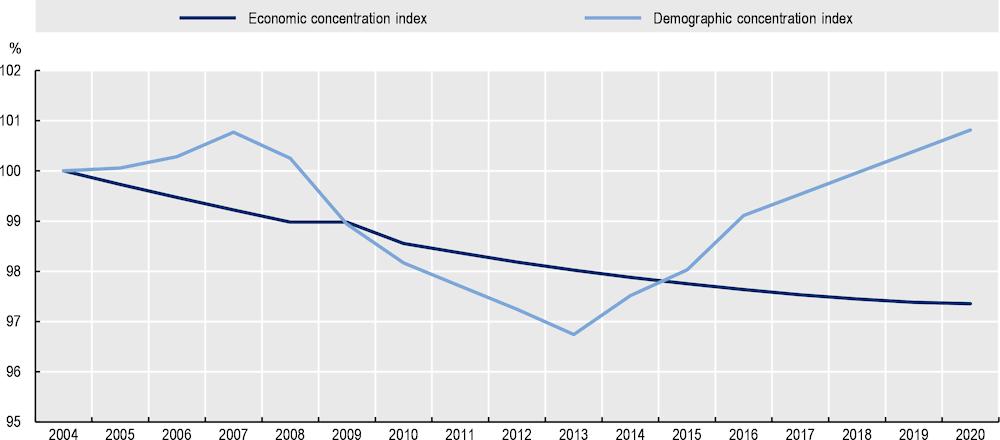
Note: The geographic concentration index offers a picture of the spatial distribution of population and economy within a country, as it compares the share of the population and the land area of each region. 2004=100. The year 2005 has been adjusted due to outliers using previous and subsequent values.
Source: Own elaboration with data from DANE (2022[13]), Departamentos y municipios de Colombia (database), https://www.datos.gov.co/Mapas-Nacionales/Departamentos-y-municipios-de-Colombia/xdk5-pm3f (accessed on 15 January 2022).
The post-COVID19 period has been used as an opportunity to bridge the territorial divide
The Colombian economy has made a remarkable recovery from the COVID-19 crisis, leaving an opportunity to redirect these efforts and a positive trend for the country’s territorial cohesion. In fact, GDP is estimated to grow by 5.5% in 2022 (OECD, 2022[17]). However, while some regions have coped relatively well with the dual health and economic crisis, others have lagged, with significant effects on the well-being of their populations. Overall, COVID-19 has exacerbated territorial inequalities that were already present before the health crisis. Medium-term growth prospects depend on reforms to expand social protection and boost productivity. Continuing efforts to make the rural economies converge is an important process that brings not only economic prosperity but also social stability and peace.
During COVID-19, the unequal access to broadband and its quality further boosted territorial inequalities in well-being in Colombia. As in most OECD countries, in Colombia, rural regions are the ones with lower shares of the population with broadband connectivity and digital skills (see the section on well-being enablers), which undermined the capacity of rural inhabitants to access work opportunities, government services, education and health though virtual means. The post-pandemic context provides an opportunity for the government of Colombia to close territorial inequalities in access to services by improving broadband connectivity and digital skills as well as implementing strategies to attract remote workers to rural areas (see Chapters 3 and 4).
In a nutshell: Assets and challenges of rural regions in Colombia
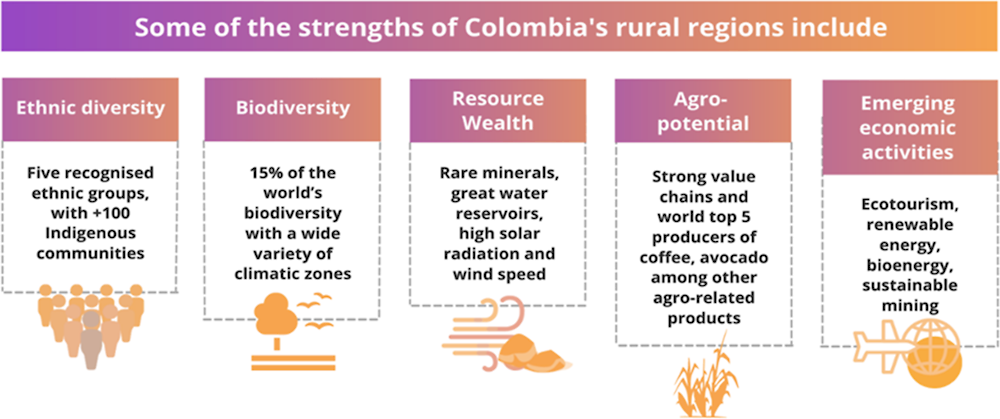
Overall, Colombia’s rural regions have a number of assets to be mobilised, including an outstanding diversity in terms of demography and environment: they are relatively young and have emerging economic activities outside agriculture.
Table 2.3. Main assets of Colombian rural regions
|
Opportunity |
Description |
|---|---|
|
Demographic bonus |
Contrary to the trend of ageing population across OECD countries, Colombian rural regions benefit from a high share of young population (26% in 2021), far above the OECD average (17%) and other OECD Latin American countries, like Chile (20%). This demographic structure is a bonus for rural regions as young people are source of innovation and vitality for communities. Regions close to small cities have the highest share of young population in Colombia (27%), |
|
Ethnic diversity |
Colombia is a source of culture, with a multi-ethnic and multilingual country including five recognised ethnic groups: i) Indigenous; ii) Raizales; iii) black or Afro-Colombian population; iv) Palenqueros; and v) Roma or Gypsy population. This multiculturalism is a source of alternative environmental knowledge and touristic potential as well as an amalgam of know‑how that is part of Colombia’s culture. |
|
Biodiversity |
The country has 15% of the planet’s biodiversity, ranking it as the 1st country in the diversity of birds and amphibians. This is both an opportunity and a responsibility, giving scope for tourism exploitation while requiring conservation/restoration programmes. This biodiversity has attracted international attention for its high environmental value, especially in the current context of ecological value awareness (FAAE, 2020[25]). |
|
Resource wealth |
The country has a wealth of very important resources, ranking 6th in water volume, with high solar radiation, 2nd in Latin America in terms of in wind speed, fertile land with no growing seasons and rare minerals. Its sustainable resource exploitation can be one of the most important development pathways for the country, especially towards the transition to a low-carbon economy that OECD countries are striving for. |
|
Agriculture value chains |
The strong value chains/innovation of sectors such as coffee or cocoa can serve as a guide for many other agricultural sectors. The country already has a number of agriculture associations that can further promote economies of scale of small farmers, which are the majority in the county (71% of farms are lower than 5 hectares). |
|
Emerging rural sectors |
|
|
Eco and cultural tourism |
To help preserve the environment, empower minorities and boost traditional economic activities. For example, Colombia has great potential for birdwatching tourism (estimates of up to 7 500 new jobs in 10 years) with existing projects involving Indigenous communities (in Guajira). If it is linked to other sectors (e.g. agriculture), tourism is capable of generating greater indirect economic effects at the local level (e.g. gastronomic routes). |
|
Renewable energy projects |
To mobilise existent natural assets (e.g. wind, solar) to decarbonise and increase the resilience of the country’s energy mix, while creating new income sources for rural communities (e.g. though benefit sharing mechanisms). |
|
Bioenergy |
To benefit from the abundant raw material of agriculture, as most of the organic waste (99%) produced in Colombia comes from agricultural and livestock activities (e.g. palm, sugarcane, biomass from agriculture or organic waste). It can provide affordable energy for rural communities and an alternative income for farmers. |
|
Environmentally sustainable mining |
To leverage the geological potential of the country to benefit from the increasing global demand for the strategic minerals needed to develop clean energy technologies, while unlocking new job opportunities locally and ensuring greater social benefits for rural communities with strategies for environmental protection and involvement of local communities. |
Infographic 2.1. Summary of strengths of Colombia’s rural regions
However, the country faces a number of medium- to long-term challenges that are bottlenecks for sustainable rural development.
Table 2.4. Main challenges of Colombian rural regions
|
Challenge |
Description |
|---|---|
|
Land informality and high concentration |
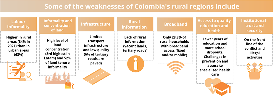
Land in Colombia is highly concentrated among few landowners. In 2017, the average Gini coefficient of land ownership in Colombia was 0.86 (UPRA, 2017[26]) (where 1 corresponds to total concentration), above the level in Latin America (0.79), Europe (0.57) or Africa (0.56) (Ariza, 2022[27]) Moreover, the rate of land tenure informality reached 52% by 2019, with at least 75 municipalities that register land informality rates between 75% and 100% (UPRA, 2020[28]). |
|
Labour informality |
Labour informality is higher in rural areas (84% in 2021) than the country average (63%). This is partially due to the high labour informality in agriculture (88% informality). In addition, informality is greater among women (48% vs. 46% in men) (DANE, 2022[29]). |
|
Lack of information |
There is a lack of information relevant to rural development in Colombia. There is no clarity on the number of vacant lands (Baldíos) or tertiary roads. There is no consolidated information system with characteristics of rural farmers or potential beneficiaries of productive programmes. |
|
Poor transport infrastructure |
Colombia’s road density (530 km per million inhabitants) is below countries of a similar level of development in Latin America such as Brazil (1 066 km) and Mexico (1 188 km). Departments in the east and west of the country are still not connected to the primary road network. Moreover, only 6% of the tertiary roads with available information are paved and many communities, whose infrastructure is still inefficient, are only reachable by river. In the 2019 World Economic Forum (WEF) Global Competitiveness Report, Colombia ranked 102 out of 140 economies in terms of road quality. |
|
Low broadband connectivity |
Given the geographic difficulty to reach rural regions with transport infrastructure, broadband access is likely one of the most important drivers of rural development in Colombia. In rural areas (according to the DANE definition), only 28.8% of households located in rural areas have broadband access (fixed and/or mobile), in contrast with 70% of households in urban areas. Moreover, fixed broadband speeds in regions far from metropolitan areas are on average 79% slower than the national average (2021). Colombia is one of the countries with the biggest urban-rural gap in broadband speeds in the OECD area. |
|
Reduced access and quality of services |
Education: About 70% of children and youth without education in Colombia are located in rural areas. The rural population has on average 3 fewer years of education than the urban population and only 5.1% of the rural population over 17 years of age has a higher education degree. Likewise, the dropout rate in upper secondary and tertiary education is higher in rural areas (45% of rural youth aged 18-22 do not complete upper secondary education). Health: Issues in healthcare access start from maternity care in rural areas, with remote rural areas registering 86 maternal deaths per 100 000 live births per year, compared to 42 maternal deaths in urban areas in 2019. Electricity: In 2021, about 10.9% of Colombian rural households lacked an electricity service, far above the 0.1% of urban households lacking this service. Water: In 2021, about 47.5% of Colombian rural households lacked access to tap water, far above the 2.5% of urban households lacking this service. Likewise, rural areas on average have a risk linked to their water quality (Water Quality Risk Index for Human Consumption of 29.9 in 2019), almost 3 times as high as urban areas (11.3). |
|
Trust in institutions and security |
The historical violence in the country had a greater impact on rural communities, becoming a barrier to the development of these areas. It impacted the infrastructure and augmented transaction costs and land conflicts. Moreover, the conflict also undermined communities’ trust in institutions, which created low levels of collaboration in some regions. Overall, in Colombia, public trust in government is low (37% of the population reported trust in government in 2019) relative to OECD (52%) and has declined over time (51% in 2017) (OECD, 2022[17]). |
Infographic 2.2. Summary of weaknesses of Colombia’s rural regions
Economic patterns shaping Colombian rural regions
Colombia and its rural regions are diversifying the economic structure
Colombia’s rural economy has evolved from an agricultural economy to a more diversified one. Until the beginning of the 1990s, agriculture was the main productive sector of Colombia and the economy as a whole was closely linked to its performance. Since the trade openness in the 1990s and the process of structural transformation, the participation of agriculture in the national economy has reduced significantly (from around 14% of the GDP in 1995 to 7.6% in 2020) (Figure 2.11).
This trend is associated with the development process of the country that has transitioned to a more urbanised territory, where the service economy has gained participation. For instance, during 2010-20, the sectors that grew the most in the economy were the public administration sector (+3.2 percentages points [pp]), as well as financial and insurance activities (+1.9 pp). All in all, this transition has indeed brought the participation of the agricultural sector closer to Latin American and closed the gap with levels of OECD countries.
Figure 2.11. Contribution of agriculture, forestry and fishing to the total economy in Colombia, OECD and Latin America average, 1995-2021
Note: Agriculture, forestry and fishing, value-added (% of GDP).
Source: World Bank (2021[18]), Database, https://data.worldbank.org/indicator/ (accessed on 2 November 2021).
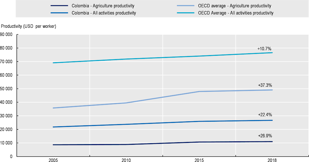
Greater labour productivity levels in other sectors have driven new economic activities to overtake agriculture and contribute to larger share of the national GDP. The labour productivity of Colombian agriculture has remained about 4 times below the average of agricultural sector in OECD during 2005-18 (Figure 2.12).
Part of the reason behind the low productivity in agriculture relates to the atomisation of landholdings in Colombia: 71% of all farms in Colombia are less than 5 hectares in size, with only 5% larger than 50 hectares. As Chapter 3 will develop, this situation poses a challenge to the scalability of the agricultural sector. Associativity among producers is an ongoing policy that leads to economies of scale to invest and manage machinery as well as to apply best-applied techniques, all aspects that improve competitiveness. Likewise, that chapter will highlight that rural information systems have room for improvement, as the suitability of crops and their management is greatly hampered by the lack of information available to experts and producers.
However, it is worth noting that agriculture has increased its productivity in recent years, accompanied by progress in agricultural extension in the country. Despite the productivity gap with other sectors, labour productivity of agriculture (sectorial GVA per worker) has increased (26.9%) from 2005 to 2018, above the labour productivity of the whole economy (22.4%) (Figure 2.12). Increasing efforts to improve enabling development factors in the rural regions (e.g. infrastructure, land formalisation, etc.) need to be maintained to boost agricultural output, improve food security and overall economic performance in the country.
Figure 2.12. Labour productivity change of agriculture, forestry and fishing of Colombia and OECD, 2005-18
Note: GVA USD per worker, constant prices, constant purchasing power parity (PPP), base year 2015. The OECD average has been made by taking the most recent available values for the missing values, with a simple average.
Source: OECD (2021[30]), OECD Regional Well-Being (database), https://www.oecdregionalwellbeing.org/ (accessed on 27 May 2019).
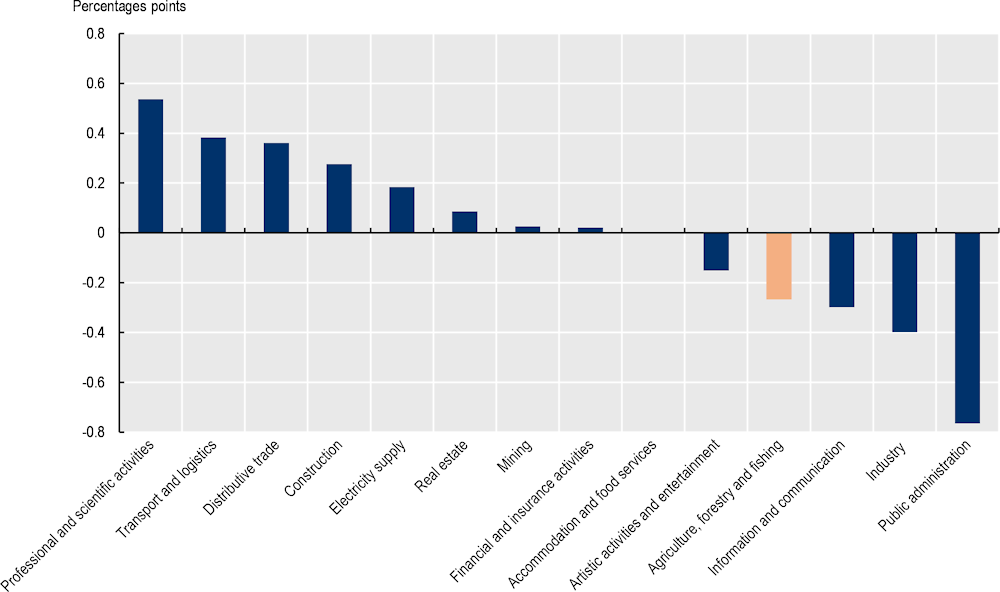
Agriculture continues to be the main employer for rural workers, but non-traditional sectors are increasingly becoming a relevant source of employment for the rural population. The national population employed in agriculture in Colombia dropped from 22% in 2000 to 16.6% in 2019. In rural economies, agriculture still employs most rural workers (60.3% in 2019), according to DANE’s territorial classification (DANE, 2022[31]).Yet, the structural transformation in the country has led to a rise of the role of service sectors in rural employment. Between 2015 and 2021, the sectors that increased the most participation in rural employment were professional and scientific activities, transport and distributive trade (Figure 2.13).
By 2019, tertiary activities2 accounted for the largest value-added of Colombia’s municipalities in rural regions (Figure 2.14). The more urbanised the municipality, the greater the presence of secondary activities, leaving the remote regions with a strong focus on primary activities, mainly agriculture, fishing, forestry and hunting. If the primary sector accounts for 20% of the value-added in rural regions close to a large city, the figure more than doubles for remote regions (41%).
Figure 2.13. Change in the share of rural employees by sector, 2015 vs. 2021
Note: This figure measures the change between 2015 and 2021 in the number of rural employees by sector as a proportion of total rural employees.
Source: DANE (2022[13]), Departamentos y municipios de Colombia (database), https://www.datos.gov.co/Mapas-Nacionales/Departamentos-y-municipios-de-Colombia/xdk5-pm3f (accessed on 15 January 2022).
Figure 2.14. Value-added by type of activity and regional typology in Colombia, 2019
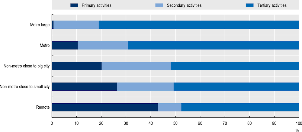
Note: By type of activity and OECD regional classification in Colombia. Calculated as the aggregate value at the municipal level in COP millions, based on 2015, current prices. Tertiary activities include: electricity, gas and water activities; commerce; repair of motor vehicles; transport; accommodation and food service; information and communication; financial and insurance; real estate activities; professional, scientific and technical activities; administrative and support service; public administration; education; health; arts and recreation; activities of individual households
Source: Own calculation based on (World Bank, 2021[18])
Economic diversity enhances the resilience of regions
OECD regions that have undertaken a catching-up process in their stages of economic development have been characterised by a high level of diversification and greater share of concentration in tradable activities (OECD, 2016[32]). Likewise, a diversified economic structure increases opportunities for innovation and economic resilience (Warf and Storper, 2000[33]). However, in Colombian rural regions, non-tradable sectors such as public administration and distributive trade are the main sources of employment (Figure 2.15).
Rural regions show higher levels of specialisation (employees in a region devoted to a single sector) than urban regions. For example, an average specialisation of 37.6% for rural regions, over 24.9% for urban regions in their more predominant sector (Annex Table 2.A.1). In the top 5 regions with a high degree of rurality, most of the employment is concentrated in public administration – e.g. Chocó (41% in 2020), Vichada (38.2%) and Caquetá (35.2%) – with the exception of those rural regions highly specialised in extractive industries- e.g. Casanare (46% in industry and mining) (Figure 2.15). In the top 5 regions with the highest share of urban population, the distributive trade sector stands out as the relevant sector in most regions- e.g. Atlántico (20.8%), Risaralda (20%), and Bogotá (19.6%). In the other high-urbanised regions, Quindío and Valle del Cauca, the predominant sectors are public administration (20.8%) and manufacturing (18.2%), respectively.
Figure 2.15. Top 5 rural-urban regions by economic specialisation in Colombia, 2021
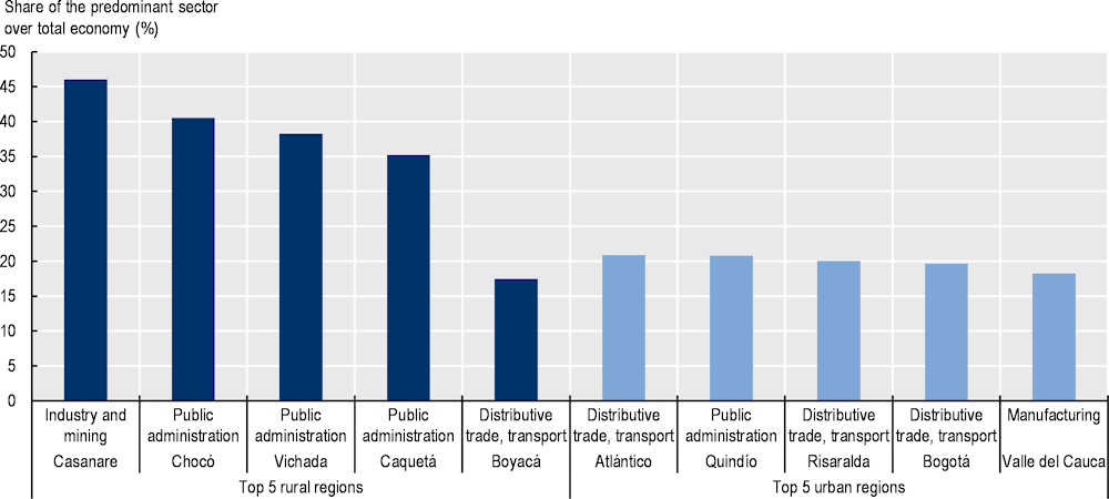
Note: Darker shade for rural regions (>50% population living in rural areas) and lighted shade for urban regions (<50% of the population living in rural areas).
Source: Own elaboration with data from DANE (2022[13]), Departamentos y municipios de Colombia (database), https://www.datos.gov.co/Mapas-Nacionales/Departamentos-y-municipios-de-Colombia/xdk5-pm3f (accessed on 15 January 2022).
Diversification can also be associated to competiveness and resilience across regions. Figure 2.16 explores regional competitiveness though the Colombian Private Competitiveness Council’s regional competitiveness index, which reveals that the most competitive regions – e.g. Antioquia, Valle del Cauca or Santander tend to record the highest levels of diversification, measured through the Herfindahl-Hirschman index (HHI).3 This contrasts with the three regions with the lowest level of competitiveness: Vichada, Guainía, which also record among the lowest levels of diversification. While the association of diversification and competiveness does not hold evenly across regions (as in Casanare or Meta), it sheds lights on drivers and goals to boost regional growth.
Figure 2.16. Departmental Competitiveness Index and Herfindahl-Hirschman Index of diversification, 2020 and 2021
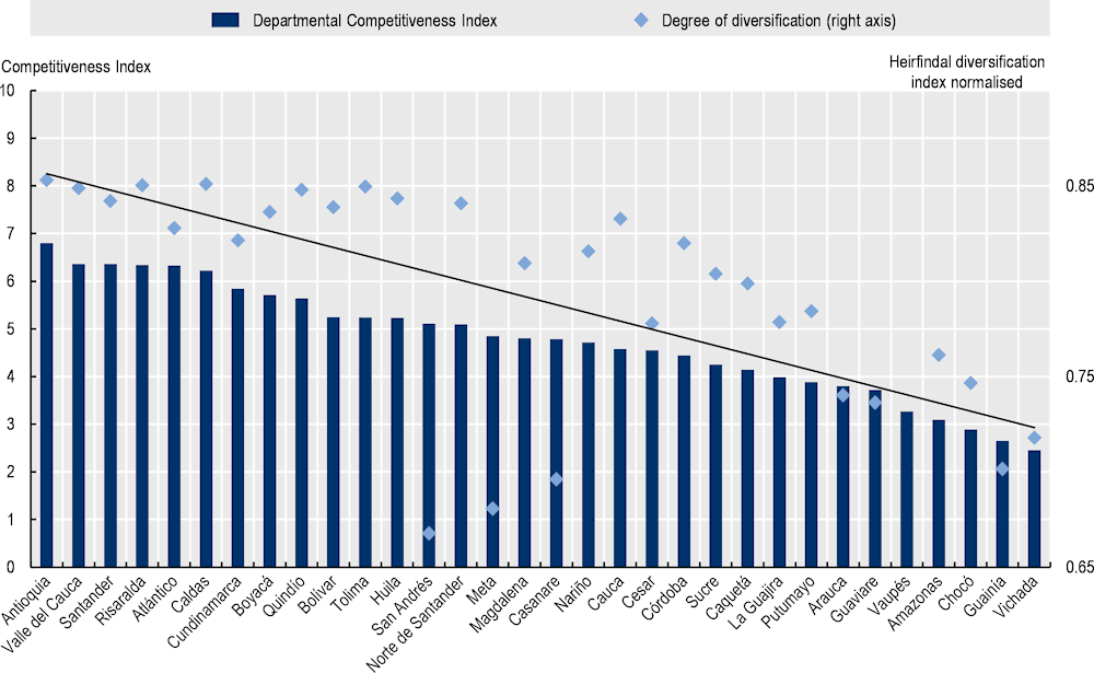
Note: The Herfindahl-Hirschman index is adapted to measure employment concentration across sectors. It is the sum of the squares of the employment shares of sectors over the regional economy. Higher values indicate greater concentration. As for the competitive index, 2020-21 has been developed by the Colombian Private Competitiveness Council (Consejo Privado de Competitividad) and consists of 4 analysis factors (enabling conditions, human capital, market efficiency and innovative ecosystem), 13 pillars (institutions, infrastructure and equipment, information and communication technology [ICT] adoption, environmental sustainability, healthcare, basic and secondary education, higher education and job training, business environment, labour market, financial system, market size, sophistication and diversification, and innovation and business dynamics) and 103 indicators.
Source: Own elaboration based on data from DANE (2022[13]), Departamentos y municipios de Colombia (database), https://www.datos.gov.co/Mapas-Nacionales/Departamentos-y-municipios-de-Colombia/xdk5-pm3f (accessed on 15 January 2022) and CPC (2021[34]), Índice Departamental de Competitividad, https://compite.com.co/indice-departamental-de-competitividad/#:~:text=En%20el%20m%C3%A1s%20reciente%20Reporte,pron%C3%B3sticos%20de%20todo%20el%20planeta (accessed on 12 March 2022).
More urban regions have greater diversity, allowing them to diversify their activities and generate sectoral interlinkages that allow for marginal increases in productivity. As productivity is one of the major bottlenecks in rural regions – as well as labour informality –, increasing diversification requires a series of important incentives and enablers, from infrastructure to innovation programmes among others as mentioned above.
Rural economies face high labour informality and low education attainment
Labour informality in Colombia is geographical more prevalent in rural economies (Figure 2.17). Colombia has long faced high levels of labour informality (63% in 2019), relative to the average of selected Latin American countries (45.9%), below Peru (78%) but above countries like Argentina, Brazil and Chile (OECD, 2022[17]). Informal employment is highly segmented by socio-economic characteristics. Most migrants, young workers, self-employed and part-time workers hold informal jobs. Labour informality in rural areas (85.6% in 2019) is almost 23% higher than the above the national average and this gap has slightly increased in the last decade (20% in 2008), although the national informality level has decreased, supported by increased development and contribution of the 2012 tax reform that reduced payroll taxes and employer’s health contributions, facilitating the supply of formal employment (OECD, 2022[17]).
Various factors help explain such geographic concentration of labour informality. First, the relevance of the agricultural sector as the main source of employment for rural economies has been accompanied by the high use of informal contracts and a low level of insertion into the social security system. The largest share of agricultural workers is classified as self-employed, followed by private sector employees, day labourers (or farm workers) and unpaid family workers. In fact, 66% of those employed in agriculture are self‑employed or day labourers and contribute less to pensions than in the urban sector (Otero-Cortés, 2019[35]). Also, the protection system is based on the individual’s ability to pay and their employment status (based on contributions), it leaves little room for inhabitants of rural areas, who have lower and more unstable incomes and often lack formal contracts. This issue is still present as pension coverage is less than 15% across rural workers (Otero-Cortés, 2019[35]). Lastly, the historic internal conflict that produced forced displacement also led to informal labour arrangements and job uncertainties (Calderón-Mejía and Ibánez, 2016[36]; Fernández, Ibánez and Peña, 2014[37]).
Moreover, high levels of business informality also led to low-quality labour contracts. Around 76% of microenterprises were not registered with the tax administration and 89% were not registered in the chamber of commerce in 2020 (OECD, 2022[17]). This is highly correlated with low compliance for hiring formal workers and following sanitary standards, e.g. 88% of microenterprises do not contribute to healthcare or to pension and 95% do not contribute to professional risks (Eslava, Haltiwanger and Pinzón, 2019[38]).
As identified in previous studies by the OECD, high mandatory social contributions and costly and complex business regulations hamper the formalisation of firms and jobs in Colombia. Some of the OECD recommendations to reduce informality include establishing a comprehensive strategy to foster formalisation, including lower non-wage costs, stronger enforcement and improvements in tax administration and a reduced tax burden on formal labour income, by gradually shifting the financing burden of social protection towards general taxation (OECD, 2022[17]).
Figure 2.17. Informality by type of region in Colombia, 2008-20
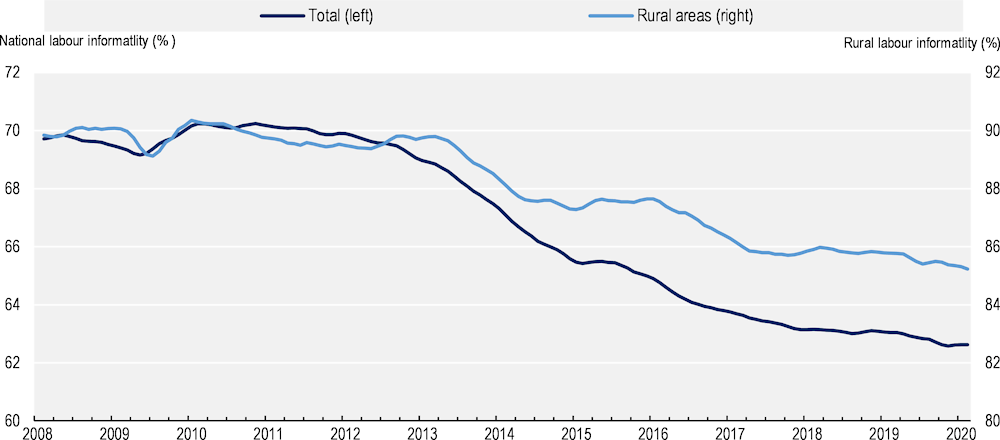
Note: Rural areas according to DANE’s classification. Twelve-month averages. Informality is defined as the percentage of workers in employment not contributing to the pension system. The statistical definition is different from the one followed by DANE. Months after the COVID-19 pandemic no included as some questions were not asked in household surveys
Source: OECD (2022[17]), OECD Economic Surveys: Colombia 2022, https://doi.org/10.1787/04bf9377-en OECD (2022[17]), OECD Economic Surveys: Colombia 2022, https://doi.org/10.1787/04bf9377-en
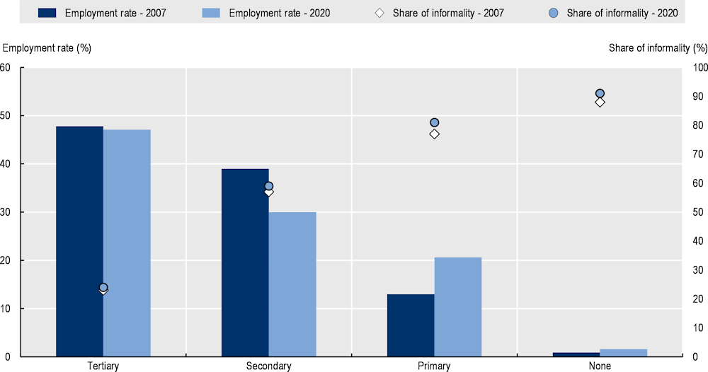
The formal employment rate is highly correlated with the educational attainment of workers (Figure 2.18). The highest employment rates are found among workers with tertiary education (47%). Moreover, the degree of informality is also lower at this level of education, accounting for only 24% as opposed to 59% for those with secondary education, 81% for primary education and 91% for those with no education. Providing training to adults and access to higher education also proves to be essential to enable formalising older workers who would find it difficult to re-enter the education system.
Figure 2.18. Employment rate and informality rate by educational attainment in Colombia, 2021
Source: Own elaboration with data taken from DANE (2022[39]), Encuesta Nacional de Calidad de Vida (ECV) 2021, https://www.dane.gov.co/files/investigaciones/condiciones_vida/calidad_vida/2020/Boletin_Tecnico_ECV_2020.pdf (accessed on 26 October 2021).
Unemployment in rural areas is lower than in urban, despite labour informality
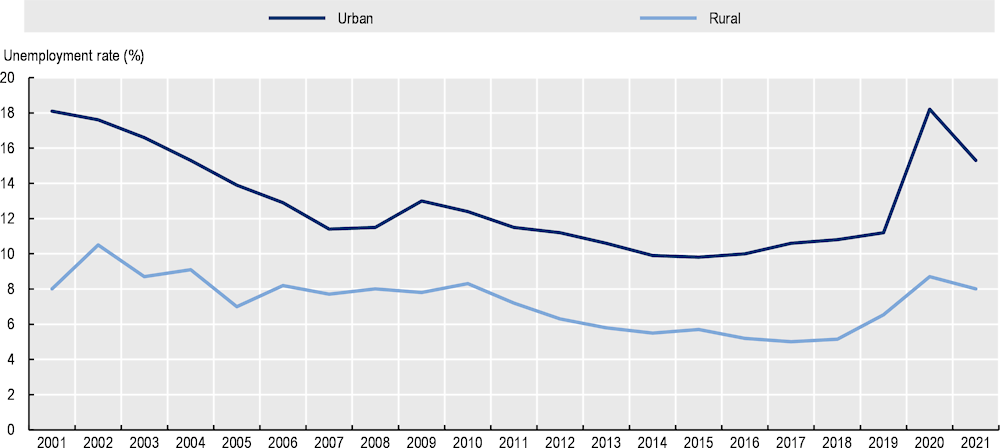
Although high levels of informality could affect statistics in comparing unemployment rates, the absorption of employment in rural areas is relatively better than in urban (Figure 2.19). In 2021, the unemployment rate in rural areas (8.1%) was lower than in urban areas (14.8%) and the national average (13.4%). The trend over the last 2 decades has been one of declining unemployment; accompanying the good performance of the economy at the national level, from 15.1% in 2001 to a level of 10.5% in 2019, before the COVID-19 pandemic (2022 would also reach a level below 11%) (DANE, 2022[31]).
Particularly positive has been the employment performance in rural areas, which has gone reached a level before the pandemic of 6.5% (2019). The COVID-19 pandemic also revealed the role of rural economies to maintain levels of employment relative to urban areas, which was associated with the relevance of primary sectors as essential activities that cushion economic shocks. Primary economic sectors, such agriculture, helped cushion the impact of the external shock and proved to be essential activities composed of indispensable workers.
Figure 2.19. Unemployment rate by typology in Colombia, 2001-21
Note: Based on DANE’s territorial classification at the municipal level (urban centres vs. dispersed rural and populated centres).
Source: DANE (2022[13]), Departamentos y municipios de Colombia (database), https://www.datos.gov.co/Mapas-Nacionales/Departamentos-y-municipios-de-Colombia/xdk5-pm3f (accessed on 15 January 2022).
Demographic patterns in Colombian rural regions
Colombia’s population continues to grow regardless of region, with particular strength in several rural areas
Urban regions have a larger population size, yet the majority of the territory is rural. Half of the regions are rural and the other half urban (16 of 32 excluding Bogotá Capital District, see Figure 2.4), although the rural regions are home to 42.1% of the country’s total population. Moreover, when looking at the administrative areas, 88% of municipalities are classified as rural, with an important share of municipalities in remote rural regions (51%).
Most urban regions, especially the capital Bogotá, have populations ranging from 7.8 million inhabitants to 562 000 in Quindío. On the rural side, Boyacá has a population of 1.2 million inhabitants and Vichada has 114 000 inhabitants. The same fortune has been experienced by the rural regions, with Vichada leading the way in population growth (128%), followed by Casanare (121%). The urban regions concentrate the highest population rates but, due to their size, their relative growth is more contained, although all the regions have experienced positive growth in the last decade.
This recent positive trend is coupled with a regional displacement within the territory as a result of the armed conflict: 774 494 households have been expelled from 1 115 municipalities and departmental districts, which means that 7.3% of the Colombian population lives or has lived in a condition of forced displacement (RUPD, 2017[40]). All in all, this phenomenon has resulted in large internal migration flows, especially from rural to urban areas of all sizes. For instance, the most affected were Antioquia with more than 100 000 displaced persons, followed by Chocó, Magdalena and Bolívar with more than 40 000. The most critical years of mass displacement were 2000, 2001 and 2002, coinciding with the increase in confrontations between guerrillas, the state and paramilitaries. This situation has improved significantly with the peace treaty, having reduced by 90% the number of displaced persons in recent years.
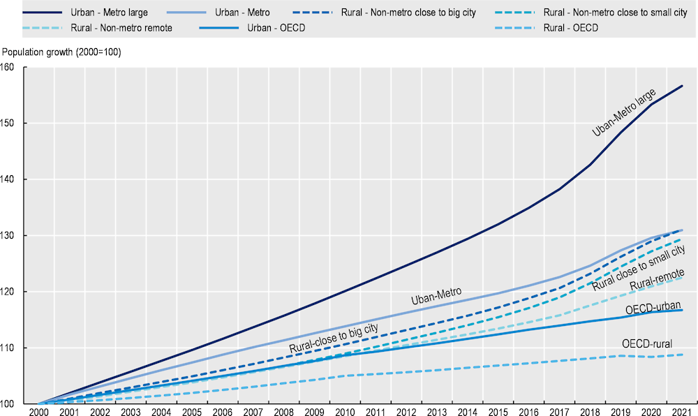
Colombia’s population has grown in all regions, especially in large metros, but aggregated increases in the rest of the regions show a rather balanced demographic increase throughout the territory (Figure 2.20). Large metro regions have grown by 57% since 2000, above the 22% of remote rural regions. For small and medium metro regions, the values are close (39% both in 2021), with urban metros maintaining slightly higher growth until the pandemic, having equalised after the COVID-19 pandemic. Rural regions close to a small city have maintained a constant gap from rural regions close to a large city over the same period (31% and 29%).
Figure 2.20. Population growth by regional typology in Colombia and OECD, 2000-21
Source: Data from OECD (2022[11]), Regional Economy (database), https://stats.oecd.org/Index.aspx?DataSetCode=REGION_ECONOM# (accessed on 3 November 2021).
In recent years there has been an important international migratory flow in Colombia, especially from Venezuela. In fact, according to figures from the Interagency Group on Mixed Migration Flows, of the 1.7 million Venezuelans who have immigrated to Colombia, around 760 000 have regular status. Of these, around 95% have the intention of staying in Colombia. In particular, Bogotá (393 716) and Antioquia (264 148) are the departments that host the most Venezuelans (Ministry of External Relations, 2021[41])
The Colombian population is young, particularly in rural areas
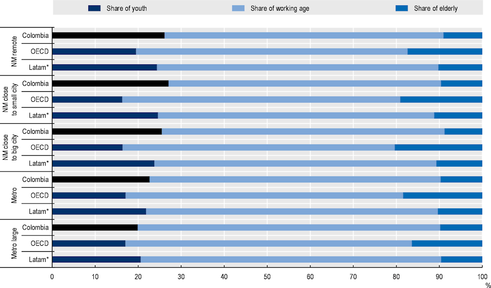
Contrary to the trend of ageing populations across OECD countries, Colombian rural regions benefit from a high share of young people (0-14 years old) (26% in 2021), far above the OECD average (17%) and other OECD Latin American countries, like Chile (20%) (Figure 2.21). This demographic structure is a bonus for rural regions as young people are a source of innovation and vitality for the community, and an important asset for future economic growth and regional attractiveness. Across rural regions, regions close to small cities have the highest share of young people in Colombia (27%), above the average for the same type of regions in Latin America (25%) and the OECD (16%).
Similarly, Colombian rural regions have a higher share of working-age population (15-64 years old) (65% in 2021) than rural regions in comparable Latin American countries (66%) and OECD countries (64%). Nevertheless, within Colombia, urban regions have a higher share of working-age population (69%), particularly large metropolitan regions.
Figure 2.21. Population structure of Colombia and OECD, 2021
Note: Data for certain OECD countries correspond to 2019 and 2020.
* The Latin America (Latam) average is made up of data from Chile and Mexico as unique OECD member countries from Latin American and, thus, using the correspondent OECD territorial typology.
Source Data from OECD (2022[11]), Regional Economy (database), https://stats.oecd.org/Index.aspx?DataSetCode=REGION_ECONOM# (accessed on 3 November 2021).
Yet, the share of young people in rural places depicts a decreasing trend
Despite the demographic bonus of Colombia’s rural regions, the share of young people is shrinking in line with international trends (Figure 2.22). Between 2009 and 2021, the share of young people over the working-age population (youth dependency ratio) in Colombia’s rural regions decreased from 49% to 41%, a more drastic drop than the OECD average (from 30% to 29% in 2019). Likewise, this ratio in Colombian urban regions felt from 39% in 2009 to 31% in 2021.
Nevertheless, the share of elderly relative to the working-age population in Colombian rural regions (14% in 2020) has remained about half of the OECD average (29%) and has increased below the trend of OECD and the Colombian urban regions (Figure 2.23). Between 2009 and 2020, this share of the elderly population in Colombian rural regions increased by 2.5 pp, below the growth in Colombian urban regions (3.7 pp) and OECD rural regions (5.6 pp). The low elderly dependency ratio benefits from a still-growing working‑age population, which can offer, with the right skills, a dynamic labour market to unlock new business opportunities.
Figure 2.22. Youth dependency ratio in Colombia and OECD average in 2009-21
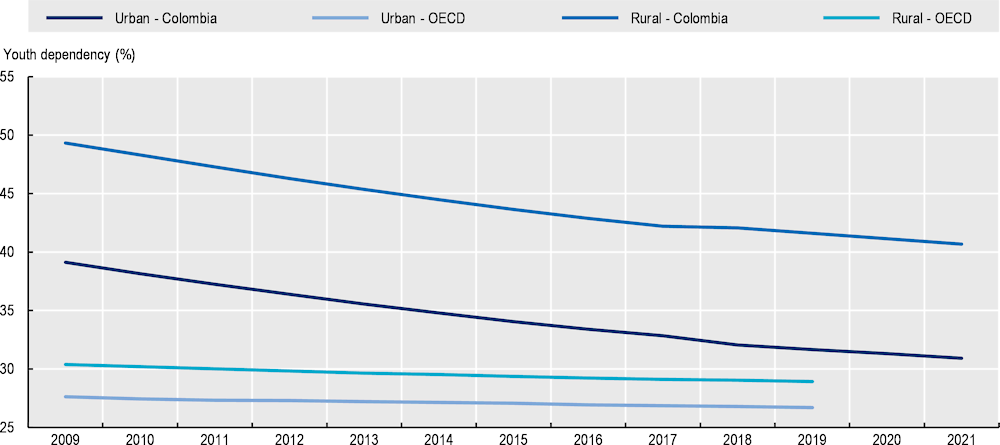
Note: The youth dependency ratio is the population ages 0-15 divided by the population ages 16-64.
Source: OECD (2022[11]), Regional Economy (database), https://stats.oecd.org/Index.aspx?DataSetCode=REGION_ECONOM# (accessed on 3 November 2021).
Figure 2.23. Elderly dependency ratio in Colombia and OECD average, 2011-21
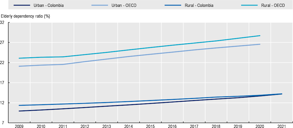
Note: The elderly dependency ratio is the population aged 65 and over divided by the population aged 16-64.
Source: Data from OECD (2022[11]), Regional Economy (database), https://stats.oecd.org/Index.aspx?DataSetCode=REGION_ECONOM# (accessed on 3 November 2021).
As in most OECD countries, there is an increasing ageing trend that calls for short-term actions to capitalise on demographic bonuses in Colombian rural regions. To this end, OECD countries are increasing their focus on the empowerment of young people and their retention in rural economies thorough better matching of education opportunities and labour offers (Chapter 4) or support to social innovation and entrepreneurship (Chapter 3).
Women’s inclusion leads to improved social cohesion and economic prosperity
Women represent 50.04% of the population living in rural regions of the country (48.2% according to DANE’s classification). While Colombia has a slightly greater proportion of women than men (95 men per 100 women), this proportion is smaller in rural (99) than in urban regions (92). Large metropolitan cities concentrate the greatest number of women (approximately 9.7 million), followed by small- and medium-sized cities (5.7 million). Instead, in rural areas, remote rural regions have the greatest number of women (4.2 million), ahead of rural regions close to small cities (3.6 million) and those close to large cities (2.8 million).
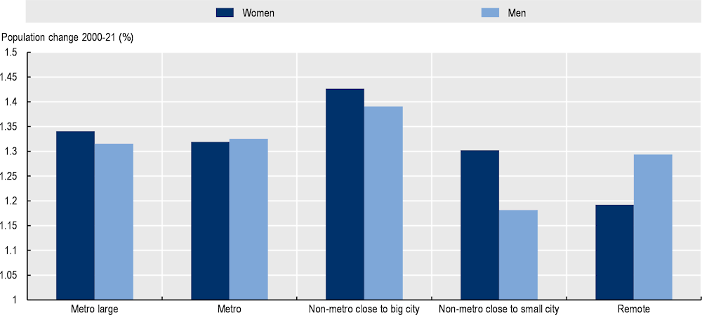
However, while young women outnumber young men in all types of Colombia regions when looking at working age, remote rural regions are the only type of regions that experience a lower share of women. This shapes population growth, with remote rural regions experiencing the highest growth of the number of men relative to women across all types of regions (Figure 2.24). This phenomenon can be associated with lower opportunities for formal work in rural economies.
Figure 2.24. Gender population change by type of region in Colombia, 2000-21
Source: Own elaboration with data from DANE (2022[13]), Departamentos y municipios de Colombia (database), https://www.datos.gov.co/Mapas-Nacionales/Departamentos-y-municipios-de-Colombia/xdk5-pm3f (accessed on 15 January 2022).
Women’s role in the rural and family economy and, thus, their social and economic conditions, have historically been invisibilised. Partly because their role in the economy has been mainly oriented towards tasks traditionally considered to be of low productivity (e.g. care roles), but indispensable for the good functioning of rural communities (Figure 2.25). In rural Colombia, only 29.2% of the employed population is female by 2020, although they represent 46.8% of the rural population in working age (DANE, 2021[42]). Consequently, unemployment rate of rural women (16.2% in 2020) is about three times higher than men (5.7%), and within the working-age population outside the labour force in rural areas (neither working nor looking for job), women represented twice the level of men (67.9% vs 32.9%). This contrasts with the higher educational attainment of rural women, where 7.9% have higher or postgraduate education, and 21.4% have secondary education, as opposed to 5.6% and 18.3% respectively for rural men (DANE, 2021[42])
All in all, women account for 82% of work in the home, as well as 59% of unpaid domestic work, compared to only 18% and 41% for men respectively. This imbalance in favour of men is also evident in other roles that provide better income in the labour market - e.g. private employees (72% men vs. 28% women) and employers (84% vs. 16%). Only the public sector in the rural context has more women (52%) than men (48%) (DANE, 2022[39]).
Figure 2.25. Occupational position by gender in rural areas in Colombia, 2019
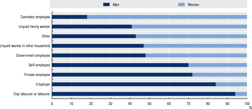
Note: Rural areas have been selected using the DANE territorial classification (DANE, 2022[13]).
Source: Own elaboration with data taken from DANE (2022[39]), Encuesta Nacional de Calidad de Vida (ECV) 2021, https://www.dane.gov.co/files/investigaciones/condiciones_vida/calidad_vida/2020/Boletin_Tecnico_ECV_2020.pdf (accessed on 26 October 2021).
This gender specialisation has implications in poverty rates, with women more exposed to poverty as they are more engaged in lower-paid economic activities. By 2020, 46.9% of households headed by women were in a situation of monetary poverty, above the 41.5% of households headed by men (DANE, 2021[42]). Against this backdrop, focusing rural policies, whether productive or social, on the needs of rural women, with recognition of their care roles, would have an important multiplier effect in reducing rural poverty and labour informality, unlocking thus new business opportunities in these economies.
Well-being enablers
Snapshot of quality of life in Colombia
Quality of life is a cornerstone to build prosperous communities, improve social cohesion and regional attractiveness for people and businesses. Due to the lack of data available to compare well‑being internationally at the provincial level (TL3 regions), the analysis presented in this section describes well‑being at the department level (TL2 regions) by adopting the OECD Regional Well-Being framework (Box 2.4). The OECD regional well-being analysis provides a tool to assess the region’s strengths and weaknesses, monitor trends and compare their results with those of other regions, nationally and internationally (Box 2.4). As the available data on well-being come from various sources (e.g. DANE, OECD regional database), each using a different territorial typology, this section uses the typologies corresponding to the source data, mentioning when it differs from the OECD taxonomy.
Box 2.4. OECD Regional Well-being indicators
Building comparable well-being indicators at a regional scale
The OECD framework for measuring regional well-being builds on the OECD Better Life Initiative at the national level. It goes further to measure well-being in regions with the idea that well-being data are more meaningful if measured where people experience it. Besides place-based outcomes, the framework also focuses on individuals, since both dimensions influence people’s well-being and future opportunities.
In line with national well-being indicators, regional well-being indicators concentrate on informing about people’s lives rather than on means (inputs) or ends (outputs). In this way, policies are directed to well‑being features that can be improved by policies. Regional well-being indicators also serve as a tool to evaluate how well-being differs across regions and groups of people. Regional well-being indicators are multidimensional and include both material dimensions and quality-of-life aspects. They also recognise the role of citizenship, institutions and governance in shaping policies and outcomes. Although well-being dimensions are measured separately, the regional well-being framework aims to allow for comparisons and interactions across multiple dimensions to account for complementarities and trade-offs faced by policy makers. At the same time, the comparison of regional well-being indicators over time allows comparing dynamics of well-being over time, as well as the sustainability and resilience of regional development.
Regional well-being in Colombia is measured along 8 well-being dimensions to reflect the quality on environment, social networks, life satisfaction, civic engagement, availability of jobs, health, education and safety (Figure 2.26). The figure below shows the details of the indicator used for each dimension.
Figure 2.26. Indicators by well-being dimension, Colombia
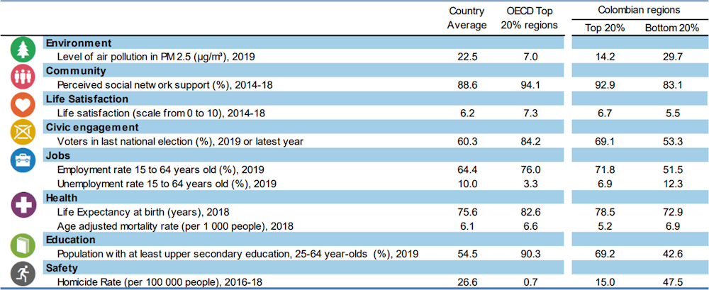
Source: OECD (n.d.[43]), OECD Regional Well-Being (database), Accessed on June 2022 www.oecdregionalwellbeing.org.
Regional well-being is measured through different areas, economic, environmental and social, which for Colombia are measured through eight dimensions (Figure 2.27). Out of these, some Colombian rural regions on two dimensions: environmental quality (on air pollution), where Vichada ranks at the top 20% of OECD regions, and community (social network support), where Arauca registers the highest performance. However, regional differences are stark in almost all well-being dimensions. In Environment, despite the good performance of Vichada, most regions are in the bottom 20% of OECD regions. This is similar in dimensions such as jobs and education. Yet, the high level of labour informality can distort the “jobs” dimension (employment and unemployment), and the high ranking of Guajira must be taken with caution. In terms of safety, all Colombian regions are part of the bottom OECD 25% regions (Figure 2.27).
Figure 2.27. Well-being regional disparity, large region (TL2)
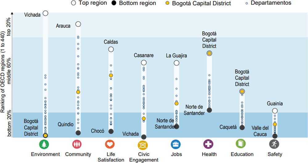
Note: Relative ranking of the regions with the best and worst outcomes in the 8 well-being dimensions, with respect to all 440 OECD regions. The 8 dimensions are ordered by decreasing regional disparities in the country. Each well-being dimension is calculated based on the indicators and time dates depicted in Figure 2.26.
Source: OECD (n.d.[43]), OECD Regional Well-Being (database), Accessed on June 2022 www.oecdregionalwellbeing.org.
Departments in Colombia, on average, experience a relatively good performance in the following dimensions:
Life satisfaction. Life satisfaction in Colombia is 6.2 on a scale between 0 and 10, broadly in line with the OECD average of 6.5. This indicator captures a reflective assessment of how things are going in one’s life and allows one to evaluate which life circumstances and conditions are important for subjective well-being. Caldas ranks as the region with the highest level of life satisfaction, close to the top 20% of the OECD, which scores 7.3.
Community perception of social network support. According to 2018 Gallup’s survey, the average of the Colombian regions registers a level of 88.6 percent, a relatively high figure given that the threshold of top 20% of the OECD is around 94 percent. As for the rural regions like Arauca, it manages to place itself among the top OECD regions with a greater perception of social networks. This dimension is relevant as it explains the nature of social interactions whose scope also has wider implication, including support for social innovation and resilience capacity.
In contrast, the four well-being dimensions where Colombian regions a markedly lower performance than OECD regions are:
Safety. Colombia concentrates almost all its regions in the bottom 20% of the OECD in terms of safety. In fact, the country average is 26.6, 10 times higher than the OECD average (2.6). Regions such as Valle del Cauca (47.5) are among the bottom 20% of the country. This is very important for the well-being of citizens, as it is part of the more structural perception of the daily living conditions. Indeed, the biggest impact of crime on people’s well-being appears to be through the feeling of vulnerability that it causes.
Civic engagement. The voter turnout in Colombia (53% in 2019) is far below the OECD average (69%). This is particularly relevant for well-being because participation in society, for example through the expression of political voice, is essential for individual well-being. Political voice is not only part of the basic freedoms and rights of human beings, but also enhances the accountability and effectiveness of public policy. Moreover, public trust in government is low (37% of the population in 2019) relative to OECD countries (52%) and has declined over time (from 51% of the population reporting trust in 2017) (OECD, 2022[17]). Low trust in public institutions also deter whistle-blowers from reporting corruption cases. In fact, 58% of Colombians consider it unlikely that complaints generate any consequences, while 78% indicate that they would suffer retaliation if they report (Pring and Vrushi, 2019[44]).
Jobs. Employment and unemployment show structural weaknesses in the country’s labour market, a fundamental building block on which to build a strong national economy. The average regional unemployment rate of Colombia regions (15.8% in 2020 last data available for international comparisons) is more than twice the OECD average (7.3%) (OECD, 2022[11]). The employment rate in Colombia is 58%, while the OECD average is 66%.
Environment. The environment in the regions of Colombia reaches very different values depending on the region, revealing a very high inequality in environmental outcomes. The average air pollution across Colombian regions (14.6 µg/m³ experienced by the population in 2019) is above the OECD average (12.0) and above European countries in the OECD (10.8). Yet, air pollution in Colombian regions is below the average across Latin-American countries in the OECD (Chile, Costa Rica, Mexico) (20.3). The average air pollution of Colombian regions classified with 100% rural degree (Figure 2.4) (14) is similar to the national average, which reveals that some regions (e.g. Arauca, Choco) face similar air pollution levels in their villages, which might be associated to methods to produce electricity (fossil fuels) or extractive activities that generate negative effects.
Civil infrastructure has proved crucial for Colombia and still has significant room for improvement
Road infrastructure
The Colombian road network spans 206 500 km2, of which 8% corresponds to the National Primary Network, 22% to the departmental network and 70% to the municipal network (also known as tertiary roads). Overall, Colombia ranks 102nd in road quality among 142 countries according to the World Economic Forum in 2019, resulting in high costs of transporting goods and people across the country and to ports (The Global Economy, 2020[45]).
Colombia ranks very similarly in quality of roads (3.0) and quality of overall infrastructure (3.1) to Brazil (3.2 and 3.1 respectively) and Argentina (3.3 and 3.2), but far behind other Latin American countries including Chile (5.2 and 4.7) and Mexico (4.4 and 4.1) (Figure 2.28). Rail infrastructure in Colombia is scarce and its quality ranks below the former four Latin American countries and the OECD.
Figure 2.28. Quality of infrastructure for Colombia and selected Latin American countries, 2017
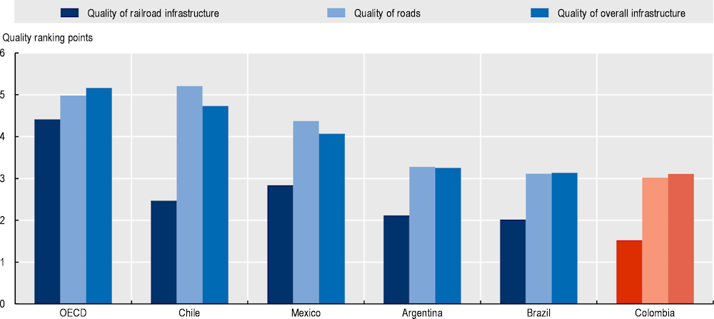
Note: Values are normalised so that on a scale of 1 to 7, the higher the value, the higher the level of infrastructure quality.
Source: WEF (2019[46]), Global Competitiveness Report 2017-2018, http://reports.weforum.org/global-competitiveness-index-2017-2018/?doing_wp_cron=1649002273.3697540760040283203125 (accessed on 12 December 2021).
The degree of isolation of Colombia’s territory has had an impact on the economic and social development of the regions. There is a high correlation pattern between the areas with the highest levels of violence, poverty and illicit crops in the country and those with developed road infrastructure (Figure 2.29). An adequate transport network would improve the accessibility of vulnerable communities to alternative sources of income and government services, including healthcare, education, security and justice.
Figure 2.29. Tertiary road density and prioritised municipalities
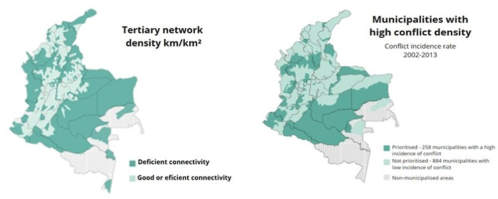
Source: Murillo, C. (2017[47]), “Desafios para el desarrollo de la red vial terciaria en el posconflicto”, https://doi.org/10.16924/revinge.45.5.
Given the geographic challenges in Colombia and the historic lag in connectivity in some rural regions, advancing other types of transport infrastructure is relevant for rural development. As explained in Chapter 4, the lack of railways and other alternative modes in Colombia led to congestion of road traffic by both passenger and freight transport.
In terms of the railway infrastructure, 49% of Colombia’s current railway network is inactive and 5% of the private network is dedicated to coal transport. the national government presented the Railway Master Plan in 2020, which is a strategy that seeks to reactivate the country’s railways and boost the economy after the pandemic caused by COVID-19 (DNP, 2020[48]). If the plan is successfully implemented, it is estimated to reduce costs by 26% by 2030, shorten logistics chain times, strengthen the attraction of foreign investment, strengthen services for transporting goods and raw materials, and increase the country’s competitiveness.
In fluvial transport, out of the 24 725 km of navigable rivers in Colombia, 74% (18 225 km) allow permanent year-round minor navigation. River transport is a passenger and freight transport alternative with great potential for use in Colombia, especially in riverine areas with a need to transport people, goods and supplies in regions that are difficult to access.
Rural communities significantly lag in broadband connectivity and speeds
Given the geographic difficulties to connect rural communities with transport infrastructure, broadband access can be an important driver of rural development in Colombia. Yet, only 28.8% of households located in rural areas (according to DANE’s classification) have access to the Internet (fixed and/or mobile), below the 70% of households that have the same service in urban areas (DANE, 2022[39]). This gap is more striking when comparing accessibility to a fixed broadband connection, in which only 12.7% of rural households have this type of connection, below the 57.6% of urban households. As mentioned in Chapter 4 home connections are indispensable to drive connectivity in a sustainable way as they allow quality access to virtual services and allow the use of data-intensive activities, such as cloud computing, and demanding applications across sectors, for example industry automation or monitoring.
At the regional level, there is still a significant gap between remote rural regions and regions in the centre of the country. For instance, Amazonas has 2%, Guainía 3% and Vaupés 0.1% of its population covered by fixed broadband connections, far below the share of population covered in Bogotá (27%) of its or Antioquia (21%) (MinTIC, 2022[49]). Especially of concern is that seven of the eight regions with the lowest share of population covered by fixed broadband access have seen a decrease in this access in the last year (MinTIC, 2022[50]).
Figure 2.30. Sample of Colombian regions with highest and lowest access to fixed broadband, Colombia, 2022Q1
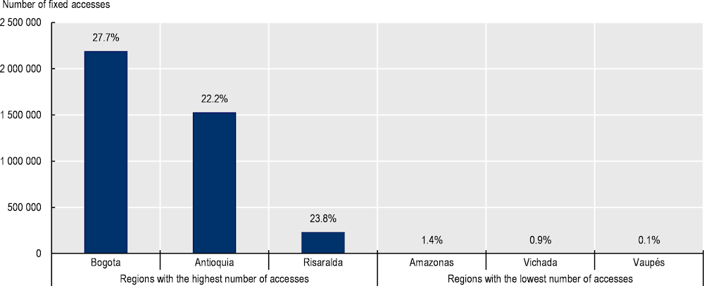
Note: Percentage represented in the columns shows the share of the population with fixed broadband access.
Source: MinTIC (2022[49]), Estadísticas MinTIC, https://colombiatic.mintic.gov.co/679/w3-propertyvalue-36342.html (accessed on 4 December 2021).
People do not only need to be connected but they also need a good connection. However, the speed of broadband services available in Colombian rural areas is considerably lower than in cities. In fact, Colombia is the fourth OECD country with the lowest fixed broadband speed in remote rural regions, relative to the OECD average (2022Q1) (Figure 2.31). Rural and remote areas have their unique “last mile” challenges due to their distance to core network facilities, making it more costly to deploy infrastructure in areas that, many times, are not commercially attractive (OECD, 2021[51]).
Figure 2.31. Gaps in fixed download speeds, by degree of urbanisation, 2022 Q1
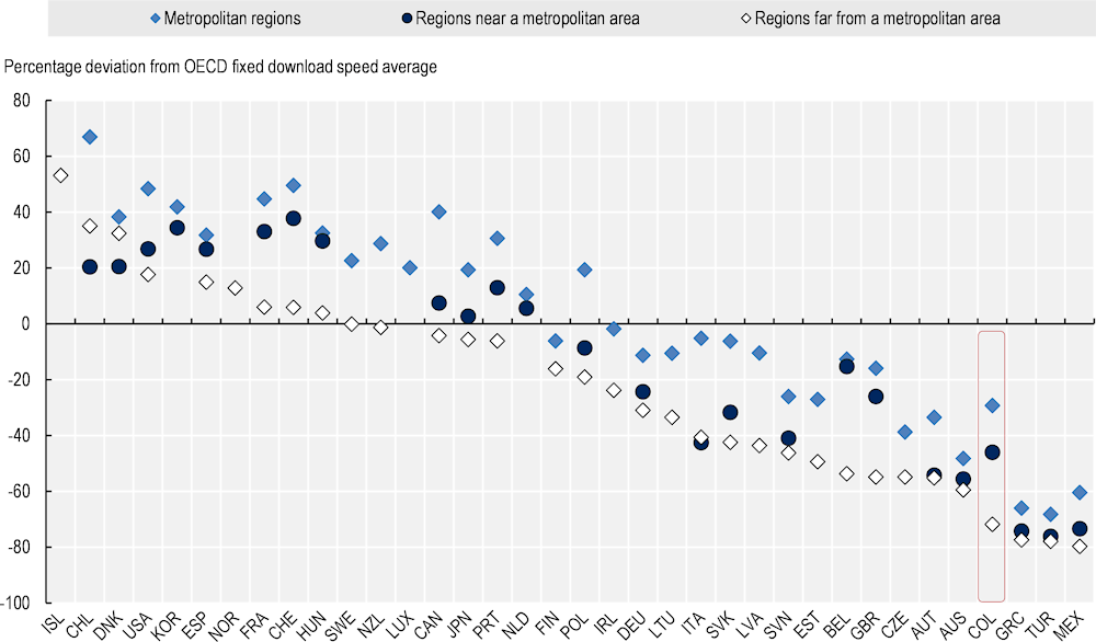
Note: The figure presents average download peak speed tests, weighted by the number of tests, as the percentage deviation (in %) from the regional (TL3) average across 36 OECD countries (Costa Rica and Israel excluded). The data for average fixed broadband download Speedtests reported by Ookla measures the sustained peak throughput achieved by users of the network. Measurements are based on self-administered tests by users, carried over iOS..
Source: OECD (2022[52]), OECD Regions and Cities at a Glance 2022, OECD Publishing, Paris, https://doi.org/10.1787/14108660-en. OECD calculations based on Speedtest® by Ookla® Global Fixed and Mobile Network Performance Maps.
Education in rural regions is progressing well in Colombia, though efforts must continue
Education in Colombia, as in OECD, is one of the fundamental promoters of a country’s state of development, both present and future. Therefore, ensuring access to education has a number of multidimensional implications. On the one hand, it promotes the growth and integral development of the population, as well as increases social mobility and breaks cycles of poverty. On the other hand, access to education allows for the accumulation of human capital, e.g. a skilled labour force that can access better-paid jobs, as well as the formation of citizens who are aware of their role in society.
In Colombian rural areas, education outcomes are generally below those in urban areas. In 2018, illiteracy was 10 pp higher in rural areas (over 14%) than in urban areas (over 4%). This territorial difference is coupled with a slight asymmetry in gender illiteracy, whereas rural women reach a level of 10.6%, lower than that observed for rural men (12.1%) (Figure 2.32). Although women in rural areas record higher levels of illiteracy compared to urban areas, the urban-rural gap for women has been reduced by a 2-pp gap between 2010 and 2018 (MinAgricultura, 2018[52]). When compared to other Latin American countries, Colombia is among those where rural men have the highest illiteracy rates (12.1%), behind Brazil (19.9%) and Ecuador (15.9%).
Figure 2.32. Illiteracy for population aged 15 years and over by sex and area, 2010 and 2018
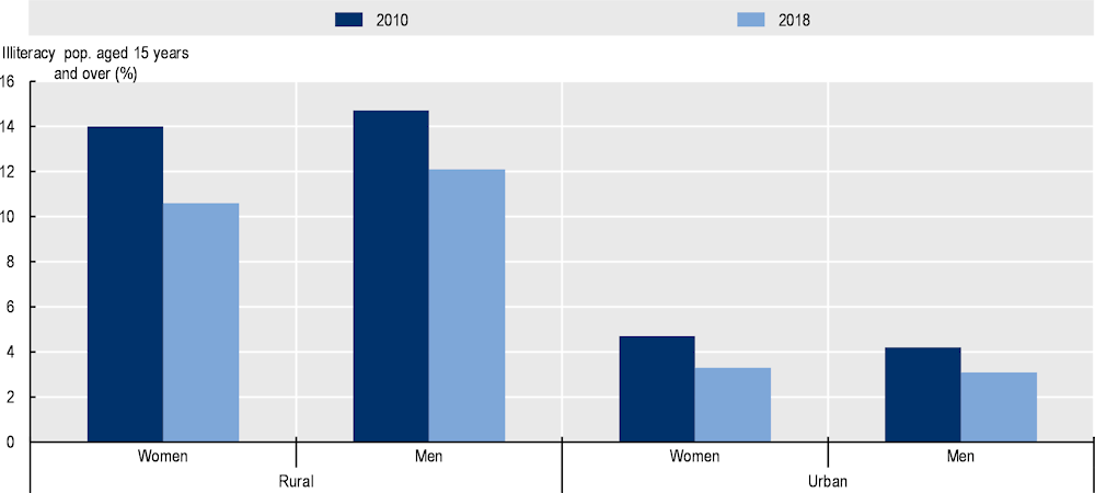
Note: Territorial typology used by DANE, is different from the OECD taxonomy (DANE, 2022[13]).
Source: Own elaboration with data from MinAgricultura (2018[52]), Situación de las Mujeres Rurales, https://www.minagricultura.gov.co/ministerio/direcciones/Documents/Situacion%20de%20las%20mujeres%20rurales%20en%20Colombia%202010-2018.pdf (accessed on 4 December 2021).
Primary educational coverage in Colombia is wide. Based on the OECD regional typology, the metro regions (86.5% in 2020) record the highest coverage levels. Rural regions close to large cities (85.7%) and those close to small cities (85%) reach relatively higher values than large metropolitan regions (84.4%). However, those lagging far behind are the remote rural regions (81%), which have much room for improvement.
Secondary education in Colombia has greatly increased since 2015, from an average net coverage of 67.4% to 73.5% in 2020 (Figure 2.33). However, the secondary graduation rate4 of Colombia (72.3% for men and 82% for women) was slightly below the OECD average (77% and 82.3% respectively). This secondary coverage not only varies by gender but also by type of region. Rural close to small city regions have made the biggest jump in the last 5 years, from 66.7% in 2015 to 77.6% in 2020. Instead, remote rural regions area still lagging and register the highest average values in both coverage (71.1% in 2020) and dropout rates (3.44%) (Figure 2.33).
Figure 2.33. Secondary education coverage and dropout rate in Colombia, OECD regional typology, 2020
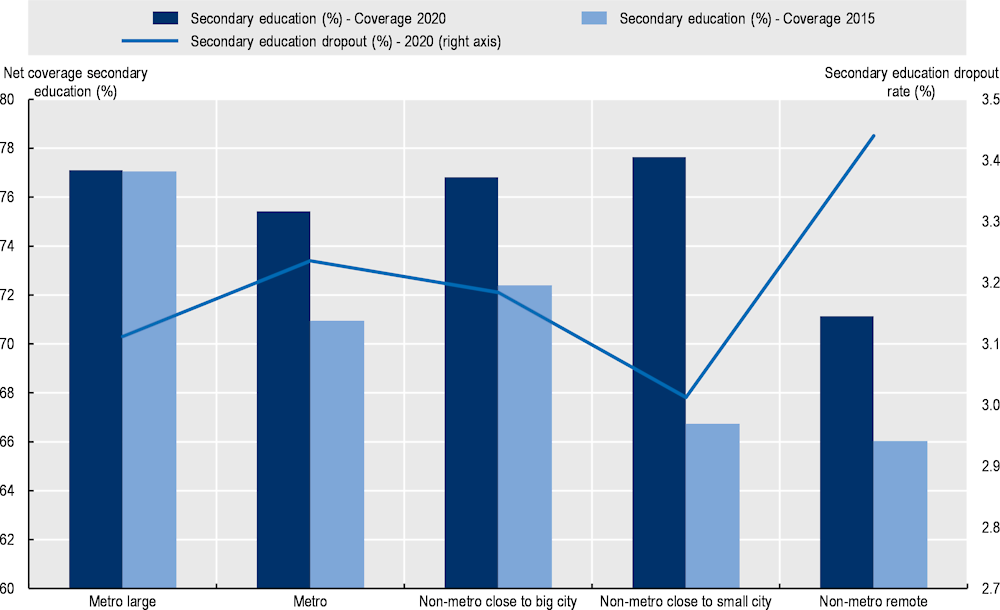
Note: Regional classification based on OECD TL3 regions typology. It was built on the basis of education data at municipal level.
Source: OECD calculations base don DANE (2022[13]), Departamentos y municipios de Colombia (database), https://www.datos.gov.co/Mapas-Nacionales/Departamentos-y-municipios-de-Colombia/xdk5-pm3f (accessed on 15 January 2022).
Environment: Biodiversity as an opportunity and deforestation as a threat
Greenhouse gas (GHG) emissions in Colombia (1.6 metric tonnes of CO2 eq. per capita in 2019) are relatively low in per capita terms (OECD average of 8.5) (Climate Watch/World Bank, 2020[53]). The country benefits from a relatively high green electricity generation, as over 70% of its electricity capacity is fed by renewable sources, especially hydroelectric plants (OECD, 2022[19]).
However, GHG emissions have increased over the last decade. While in 2010, Colombia emitted 1.4 tonnes of GHG emissions per capita, the figure rose to 1.6 in 2019 (latest year available) as opposed to the decrease in OECD (from 9.8 in 2010 to 8.5 in 2019). The causes of these emissions are not homogeneous across the country (Figure 2.34). Rural regions are responsible for most of the total GHG emissions (73%) in the country, compared to urban regions (27%). This is associated with the greater specialisation of rural economies in agriculture, which is the sector that represents the greatest share of emissions in Colombia (32%). Agriculture represents on average 44% of rural region GHG emissions. In metropolitan regions, residential (9% of the country’s GHG emissions) and transport (6%) are the main sources of emissions.
Figure 2.34. GHG emissions by type of region and source in Colombia, 2020
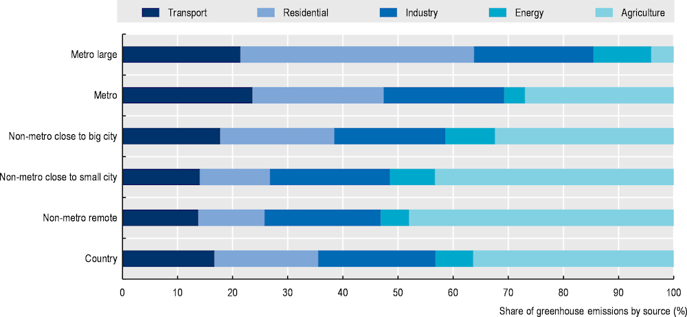
Source: Own calculation with data from OECD (2022[11]), Regional Economy (database), https://stats.oecd.org/Index.aspx?DataSetCode=REGION_ECONOM# (accessed on 3 November 2021).
It is worth noting that emissions from land use changes are not included in this disaggregation, which is a relevant issue in Colombia. Deforestation has risen in recent years, about 8 pp in 2020 compared to the total area devoted to the forest the year before. As part of the institutional efforts to tackle this issue, Colombia has committed to an ambitious target of zero net deforestation by 2030. Remarkable institutional efforts to curb deforestation have included a satellite-based early detection system (e.g. Operacion Artemisa)5, but limited resources for enforcement action only allows following up on a minor fraction of detections (OECD, 2022[17]). Moreover, the country has made efforts in climate adaptation by increasing to 18 000 hectares in the process of restoration, rehabilitation and/or ecological recovery in protected areas of the National Natural Parks System and its areas of influence.
Bogotá leads as the region with the largest increase in forest (+9 pp in 2020) (Figure 2.35). The increase in green spaces and the maintenance of existing ones followed by a lower forest base than in other regions due to its character as a capital city has led to this increase, which would be difficult to achieve in a rural area that already has large tracts of forest. In fact, rural regions are more clustered around values close to 0, with both negative and positive exceptions. The negative rates are most notable in Atlántico with a rate of more than 7 pp, followed by the rural regions of Arauca (-1.2 pp) and Guaviare (-0.2 pp), and the rural regions with positive rates are Córdoba (5.8 pp) and La Guajira (4.3 pp). Urban regions such as Meta (-.3 pp) or Norte de Santander (-1 pp) should also make efforts to curb deforestation and maintain healthy green spaces.
Figure 2.35. Changes in forest area by department and degree of rurality, 2020
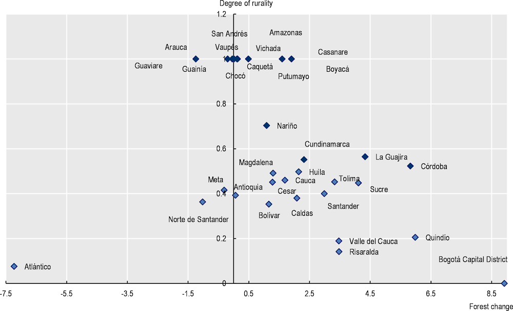
Note: Darker markers refer to rural regions and lighter markers to urban regions.
Source: Own elaboration with data from OECD (2022[11]), Regional Economy (database), https://stats.oecd.org/Index.aspx?DataSetCode=REGION_ECONOM# (accessed on 3 November 2021).
Security and land access
Colombia’s historic conflict has hampered quality of life and investment attraction in rural communities, which has also led an accelerated rural-urban migration. The National Registry of Displaced Population (RUPD) established that, in Colombia, 774 494 households have been expelled from 1 115 municipalities, which means that 7.3% of the Colombian population lives or has lived in a condition of forced displacement. According to the same registry, 87% of the victims of the conflict were displaced in 2014 (RUPD, 2016[54]).
Rural economic activities have historically been the most impacted by this conflict in terms of the destruction of infrastructure and the intervention of armed actors in economic activity in rural areas, which increases transaction costs for inputs and final products. In addition, it reduced workforce availability due to the recruitment of people by illegal groups, death and displacement. It also impacted investment decisions, making, for example, farmers adopt low-profit production strategies to minimise risks. Studies have estimated that during the 90s, its effects on the growth rate of total GDP were between 0.3 and 0.7 pp per year (Restrepo, Spagat and Vargas, 2003[55]).
Access to land, as well as its distribution and titling, has been one of the most important bottlenecks to rural development in Colombia. Land is also a key asset for unlocking economic opportunities associated with environmental preservation and climate change mitigation in rural areas. While traditional sectors such as agriculture and mining depend on access to land to develop activities, this is also true for sectors such as the bioeconomy, renewable energy and ecotourism and forest conservation. However, green economy sectors can benefit from different forms of land ownership, such as collective ownership, concessions and user rights, indicating that security of tenure can coexist with sustainable development. Land management analysis will receive a central focus in Chapter 5 of this review.
References
[27] Ariza, F. (2022), “Distribución de la propiedad rural en Colombia en el siglo XXI”, Revista de Economia e Sociologia Rural, Vol. 60/4, https://doi.org/10.1590/1806-9479.2021.242402.
[36] Calderón-Mejía, V. and A. Ibánez (2016), “Labour market effects of migration-related supply shocks: Evidence from internal refugees in Colombia”, Journal of Economic Geography, Vol. 16/3.
[20] Camargo, G. et al. (2020), “Exploring the dynamics of migration, armed conflict, urbanization, and anthropogenic change in Colombia”, Plos ONE, Vol. 15/11, https://doi.org/10.1371/journal.pone.0242266.
[61] CEDLAS/World Bank (2021), Socio-Economic Database for Latin America and the Caribbean, https://www.cedlas.econo.unlp.edu.ar/wp/en/estadisticas/sedlac/estadisticas/#1496165425791-920f2d43-f84a (accessed on 24 March 2022).
[60] CEPAL (2019), Social Panorama of Latin America, https://www.cepal.org/sites/default/files/publication/files/46688/S2100149_en.pdf (accessed on 2 December 2021).
[8] CEPAL (2016), Configuración territorial de las provincias de Colombia, United Nations, http://www.dane.gov.co/files/censo2005/provincias/subregiones.pdf.
[54] Climate Watch/World Bank (2020), GHG Emissions, World Resources Institute, Washington, DC.
[34] CPC (2021), Índice Departamental de Competitividad, https://compite.com.co/indice-departamental-de-competitividad/#:~:text=En%20el%20m%C3%A1s%20reciente%20Reporte,pron%C3%B3sticos%20de%20todo%20el%20planeta. (accessed on 12 March 2022).
[21] DANE (2022), Cuentas Departamentales, https://www.dane.gov.co/index.php/estadisticas-por-tema/cuentas-nacionales/cuentas-nacionales-departamentales.
[13] DANE (2022), Departamentos y municipios de Colombia (database), https://www.datos.gov.co/Mapas-Nacionales/Departamentos-y-municipios-de-Colombia/xdk5-pm3f (accessed on 15 January 2022).
[39] DANE (2022), Encuesta Nacional de Calidad de Vida (ECV) 2021, https://www.dane.gov.co/files/investigaciones/condiciones_vida/calidad_vida/2020/Boletin_Tecnico_ECV_2020.pdf (accessed on 26 October 2021).
[31] DANE (2022), Gran Encuesta Integrada de Hogares, Población ocupada según su actividad económica y por cuenta propia, https://www.dane.gov.co/index.php/estadisticas-por-tema/mercado-laboral/empleo-y-desempleo/poblacion-ocupada-segun-su-actividad-economica-y-por-cuenta-propia (accessed on October 2022).
[29] DANE (2022), The Great Integrated Household Survey, https://www.dane.gov.co/index.php/estadisticas-por-tema/mercado-laboral/empleo-y-desempleo.
[42] DANE (2021), Situación de las mujeres rurales en colombia, Serie Notas Estadísticas, http://www.dane.gov.co/files/investigaciones/notas-estadisticas/oct-2021-nota-estadistica-situacion-mujeres-rurales-colombia-presentacion.pdf.
[14] DANE (2018), Censo nacional de población y vivienda 2018.
[9] DANE (n.d.), Codificación municipal por provincia y subregión, http://www.dane.gov.co/files/censo2005/provincias/subregiones.pdf.
[4] DNP (2020), Misión para el Fortalecimiento del Sistema de Ciudades, https://www.dnp.gov.co/programas/vivienda-agua-y-desarrollo-urbano/desarrollo-urbano/Paginas/sistema-de-ciudades.aspx#:~:text=El%20sistema%20de%20ciudades%20en,regiones%20y%20para%20el%20pa%C3%ADs. (accessed on 12 December 2021).
[48] DNP (2020), Plan Maestro Ferroviario, https://colaboracion.dnp.gov.co/CDT/Prensa/Plan-Maestro-Ferroviario.pdf.
[2] DNP (2014), Misión para la Transformación del Campo, https://colaboracion.dnp.gov.co/CDT/Agriculturapecuarioforestal%20y%20pesca/Definicion%20Categor%C3%ADas%20de%20Ruralidad.pdf (accessed on 4 December 2021).
[38] Eslava, M., J. Haltiwanger and A. Pinzón (2019), “Job creation in Colombia vs the U.S.: “Up or out dynamics” meets “the life cycle of plants“”, National Bureau of Economic Research, Cambridge, MA, https://doi.org/10.3386/w25550.
[25] FAAE (2020), La importancia de la biodiversidad, https://www.faae.org.co/colombiabiodiversa/biodiversidad-en-colombia.html#:~:text=Colombia%20es%20un%20pa%C3%ADs%20con,de%20mam%C3%ADferos%20(471%20especies). (accessed on 12 March 2022).
[10] Fadic, M. et al. (2019), “Classifying small (TL3) regions based on metropolitan population, low density and remoteness”, OECD Regional Development Working Papers, No. 2019/06, OECD Publishing, Paris, https://doi.org/10.1787/b902cc00-en.
[62] Fernández de Soto, C. (2019), “Diversificar: productividad y calidad”, LaRepublica, https://www.larepublica.co/analisis/camilo-fernandez-de-soto-2930538/diversificar-productividad-y-calidad-2930536 (accessed on 2 February 2022).
[37] Fernández, M., A. Ibánez and X. Peña (2014), “Adjusting the labor supply to mitigate violent shocks: Evidence from rural Colombia”, Journal of Development Studies, Vol. 50/8.
[53] MinAgricultura (2018), Situación de las Mujeres Rurales, https://www.minagricultura.gov.co/ministerio/direcciones/Documents/Situacion%20de%20las%20mujeres%20rurales%20en%20Colombia%202010-2018.pdf (accessed on 4 December 2021).
[41] Ministry of External Relations (2021), Distribución de Venezolanos en Colombia - Corte 31 de Agosto de 2021, https://www.migracioncolombia.gov.co/infografias/distribucion-de-venezolanos-en-colombia-corte-31-de-agosto-de-2021.
[15] Ministry of Health and Social Protection (2020), Boletines Poblacionales.
[50] MinTIC (2022), Boletin Trimestrial de las TIC, https://colombiatic.mintic.gov.co/679/articles-198842_archivo_pdf.pdf (accessed on 13 February 2022).
[49] MinTIC (2022), Estadísticas MinTIC, https://colombiatic.mintic.gov.co/679/w3-propertyvalue-36342.html (accessed on 4 December 2021).
[47] Murillo, C. (2017), “Desafios para el desarrollo de la red vial terciaria en el posconflicto”, Revista de Ingeniería 45, pp. 32-39, https://doi.org/10.16924/revinge.45.5.
[59] OECD (2022), Agricultural Policy Monitoring and Evaluation 2022: Reforming Agricultural Policies for Climate Change Mitigation, OECD Publishing, Paris, https://doi.org/10.1787/7f4542bf-en.
[19] OECD (2022), Economic Outlook : Colombia, OECD, Paris, https://www.oecd.org/economy/colombia-economic-snapshot/ (accessed on 1 March 2022).
[12] OECD (2022), National Urban Policy Review of Colombia, OECD Urban Studies, OECD Publishing, Paris, https://doi.org/10.1787/9ca1caae-en.
[17] OECD (2022), OECD Economic Surveys: Colombia 2022, OECD Publishing, Paris, https://doi.org/10.1787/04bf9377-en.
[52] OECD (2022), OECD Regions and Cities at a Glance 2022, OECD Publishing, Paris, https://doi.org/10.1787/14108660-en.
[11] OECD (2022), Regional Economy (database), OECD, Paris, https://stats.oecd.org/Index.aspx?DataSetCode=REGION_ECONOM# (accessed on 3 November 2021).
[24] OECD (2021), Better Governance, Planning and Services in Local Self-Governments in Poland, OECD Publishing, Paris, https://doi.org/10.1787/550c3ff5-en.
[51] OECD (2021), Bridging Digital Divides in G20 Countries, OECD Publishing, Paris, https://doi.org/10.1787/35c1d850-en.
[5] OECD (2021), “Colombian responses to OECD questionnaire on rural policy”, Unpublished, OECD, Paris.
[30] OECD (2021), OECD Regional Well-Being (database), OECD, Paris, https://www.oecdregionalwellbeing.org/ (accessed on 27 May 2019).
[1] OECD (2020), Rural Well-being: Geography of Opportunities, OECD Rural Studies, OECD Publishing, Paris, https://doi.org/10.1787/d25cef80-en.
[6] OECD (2019), OECD Principles on Rural Policy, https://www.oecd.org/cfe/regionaldevelopment/Principles%20on%20Rural%20Policy%20Brochure%202019_Final.pdf.
[57] OECD (2019), PISA 2018 Results (Volume I): What Students Know and Can Do, PISA, OECD Publishing, Paris, https://doi.org/10.1787/5f07c754-en.
[22] OECD (2018), A Broken Social Elevator? How to Promote Social Mobility, OECD Publishing, Paris, https://doi.org/10.1787/9789264301085-en.
[23] OECD (2017), OECD Economic Surveys: Colombia 2017, OECD Publishing, Paris, https://doi.org/10.1787/eco_surveys-col-2017-en.
[32] OECD (2016), OECD Regional Outlook 2016: Productive Regions for Inclusive Societies, OECD Publishing, Paris, https://doi.org/10.1787/9789264260245-en.
[3] OECD (2006), The New Rural Paradigm: Policies and Governance, OECD Rural Policy Reviews, OECD Publishing, Paris, https://doi.org/10.1787/9789264023918-en.
[43] OECD (n.d.), OECD Regional Well-Being (database), OECD, Paris, https://www.oecdregionalwellbeing.org/ (accessed on June 2022).
[58] OECD/European Commission (2020), Cities in the World: A New Perspective on Urbanisation, OECD Urban Studies, OECD Publishing, Paris, https://doi.org/10.1787/d0efcbda-en.
[35] Otero-Cortés, A. (2019), “Rural labor markets in Colombia, 2010-2019”, Documentos de Trabajo sobre Economía Regional y Urbana, No. 281, Banco de la República.
[44] Pring, C. and J. Vrushi (2019), Global Corruption Barometer Latin America & The Caribbean 2019: Citizens’ Views and Experiences of Corruption, https://digitalcommons.fiu.edu/srhreports/toc/toc/37/ (accessed on 3 March 2022).
[56] Restrepo, J., M. Spagat and J. Vargas (2003), “The dynamics of the Colombian civil conflict: A new data set”, Homo Oeconomicus, Vol. 21, https://www.researchgate.net/publication/5009246_The_Dynamics_of_the_Colombian_Civil_Conflict_A_New_Data_Set.
[63] Rhoades, S. (1993), “The herfindahl-hirschman index”, Fed. Res. Bull., 79, 188.
[7] RIMISP-DNP (2018), Lineamientos conceptuales y metodológicos para la definición de una subregionalización funcional en Colombia, https://colaboracion.dnp.gov.co/CDT/Desarrollo%20Territorial/Portal%20Territorial/Kit%20Asociatividad%20Territorial/Documento%20Metodol%C3%B3gico%20Subregiones%20Funcionales.pdf.
[40] RUPD (2017), Desplazamiento Forzado en Colombia, http://www.archivodelosddhh.gov.co/saia_release1/almacenamiento/ACTIVO/2016-07-18/160616/anexos/1_1468895750.pdf (accessed on 15 January 2022).
[55] RUPD (2016), Desplazamiento Forzado en Colombia, http://www.archivodelosddhh.gov.co/saia_release1/almacenamiento/ACTIVO/2016-07-18/160616/anexos/1_1468895750.pdf (accessed on 13 January 2022).
[45] The Global Economy (2020), Roads Quality - Country Rankings, https://www.theglobaleconomy.com/rankings/roads_quality/.
[28] UPRA (2020), Informalidad de la tenencia de la tierra en Colombia, https://www.upra.gov.co/documents/10184/104284/01_informalidad_tenencias_tierras.
[26] UPRA (2017), Análisis de distribución de la propiedad rural en Colombia. Resultados 2017, MADR, UPRA. Bogotá.
[33] Warf, B. and M. Storper (2000), “The regional world: Territorial development in a global economy”, Economic Geography, Vol. 76/1, p. 101, https://doi.org/10.2307/144543.
[46] WEF (2019), Global Competitiveness Report 2017-2018, World Economic Forum, http://reports.weforum.org/global-competitiveness-index-2017-2018/?doing_wp_cron=1649002273.3697540760040283203125 (accessed on 12 December 2021).
[18] World Bank (2021), Database, World Bank, Washington, DC, https://data.worldbank.org/indicator/ (accessed on 2 November 2021).
[16] World Bank (2020), World Bank National Accounts Data, World Bank, Washington, DC.
Annex 2.A. Sectorial specialisation in Colombian regions
Annex Table 2.A.1. Sectoral specialisation over the total regional economy by department in Colombia, 2020
|
Agriculture, forestry and fishing (%) |
Industry, manufacturing and mining (%) |
Construction (%) |
Distributive trade (%) |
IT and financial services (%) |
Public administration (%) |
Real estate (%) |
Others (%) |
Degree of rurality |
|
|---|---|---|---|---|---|---|---|---|---|
|
Bogotá |
0 |
11 |
4 |
20 |
16 |
18 |
16 |
15 |
1.0 |
|
Atlántico |
1 |
25 |
6 |
21 |
8 |
18 |
9 |
11 |
0.9 |
|
Risaralda |
8 |
18 |
6 |
20 |
8 |
19 |
9 |
13 |
0.9 |
|
Valle del Cauca |
6 |
22 |
4 |
17 |
8 |
15 |
15 |
13 |
0.8 |
|
Quindío |
17 |
8 |
7 |
20 |
6 |
21 |
13 |
8 |
0.8 |
|
Bolívar |
6 |
24 |
10 |
15 |
5 |
22 |
8 |
10 |
0.6 |
|
Norte de Santander |
11 |
12 |
9 |
17 |
6 |
28 |
11 |
8 |
0.6 |
|
Caldas |
11 |
22 |
6 |
17 |
7 |
19 |
8 |
11 |
0.6 |
|
Antioquia |
6 |
24 |
7 |
16 |
9 |
13 |
11 |
13 |
0.6 |
|
Santander |
11 |
28 |
8 |
15 |
7 |
14 |
10 |
7 |
0.6 |
|
Meta |
12 |
53 |
4 |
11 |
3 |
10 |
4 |
3 |
0.6 |
|
Sucre |
11 |
11 |
9 |
16 |
5 |
36 |
6 |
5 |
0.6 |
|
Cesar |
10 |
38 |
4 |
12 |
4 |
20 |
6 |
6 |
0.5 |
|
Tolima |
18 |
17 |
7 |
17 |
6 |
20 |
7 |
8 |
0.5 |
|
Cauca |
14 |
23 |
8 |
11 |
4 |
24 |
6 |
10 |
0.5 |
|
Magdalena |
17 |
7 |
5 |
19 |
6 |
32 |
7 |
6 |
0.5 |
|
Huila |
20 |
15 |
8 |
16 |
6 |
22 |
7 |
7 |
0.5 |
|
Córdoba |
12 |
18 |
5 |
14 |
6 |
31 |
4 |
10 |
0.5 |
|
Cundinamarca |
17 |
30 |
6 |
15 |
4 |
14 |
6 |
7 |
0.4 |
|
La Guajira |
6 |
28 |
9 |
15 |
4 |
32 |
6 |
3 |
0.4 |
|
Nariño |
17 |
5 |
8 |
19 |
5 |
31 |
10 |
6 |
0.3 |
|
Amazonas |
20 |
5 |
4 |
24 |
4 |
37 |
4 |
2 |
0.0 |
|
Arauca |
20 |
42 |
4 |
9 |
2 |
16 |
4 |
1 |
0.0 |
|
Boyacá |
13 |
27 |
10 |
17 |
4 |
16 |
7 |
6 |
0.0 |
|
Caquetá |
17 |
4 |
9 |
16 |
5 |
35 |
9 |
5 |
0.0 |
|
Casanare |
14 |
46 |
3 |
19 |
2 |
9 |
3 |
2 |
0.0 |
|
Chocó |
21 |
16 |
4 |
12 |
3 |
41 |
2 |
1 |
0.0 |
|
Guainía |
11 |
7 |
13 |
14 |
3 |
49 |
4 |
1 |
0.0 |
|
Guaviare |
23 |
3 |
7 |
14 |
3 |
42 |
5 |
1 |
0.0 |
|
Putumayo |
7 |
26 |
7 |
15 |
3 |
33 |
6 |
4 |
0.0 |
|
San Andrés |
2 |
4 |
3 |
53 |
6 |
21 |
6 |
5 |
0.0 |
|
Vaupés |
8 |
1 |
9 |
21 |
1 |
54 |
5 |
1 |
0.0 |
|
Vichada |
34 |
2 |
9 |
8 |
3 |
38 |
5 |
1 |
0.0 |
Notes
← 1. In addition to this OECD regional classification, the OECD also uses a granular territorial methodology to classify local units into cities, towns/semi-dense areas and rural areas: the degree of urbanisation, which was endorsed at the 2020 United Nations Statistical Commission (OECD/European Commission, 2020[57]). The OECD Rural Review of Colombia uses the regional classification to determine the level of rurality to better recognise interactions and trends across different types of regions in Colombia
← 2. Primary activities include agriculture, livestock, forestry and fishing activities, mining and quarrying. Secondary activities include manufacturing and construction activities. Tertiary activities include electricity, gas and water activities; commerce; repair of motor vehicles; transport; accommodation and food service activities; information and communication; financial and insurance activities; real estate activities; professional, scientific and technical activities; administrative and support service activities; public administration; education; health; arts, entertainment and recreation; activities of individual households.
← 3. The Herfindahl-Hirschman index is adapted to measure employment concentration across sectors. The value of the index is the sum of the squares of the employment shares of sectors over the regional economy. Higher values indicate greater concentration. The formula of the Herfindahl index below represent the sum of the employment share (X) of the sector J in economy m for the time t.:
← 4. The secondary graduation rate represents the estimated percentage of people who will graduate from secondary education over their lifetime. Data are broken down by gender and shown for upper secondary and post-secondary, non-tertiary levels of education.
← 5. Operación Artemisa is a military public policy strategy that aims to protect 200 000 hectares of forest every year. It has been recently renewed (January 2022) by the president of Colombia, Ivan Duque.
