This chapter focuses on the spatial dynamics of population distribution and growth trends over the last decade. It uses population size – along with reachability measures – to classify settlements. The analysis focuses on the European Union due to the availability of grid-level data on population changes for mid‑size settlements. Urbanisation trends are apparent along the rural-urban continuum, even amidst the European context of a declining population. On average, larger cities are growing faster than small cities and, in turn, faster than towns and villages. Towns near cities grew more than the cities themselves, while many settlements far from cities lost population. Regression analysis, adjusting for local growth patterns, indicates that settlements with greater service provision generally had more positive population growth. The findings suggest that, over the past decade, urbanisation (and remoteness) has played a greater role than services in population growth (and loss) in European towns and small cities.
Getting to Services in Towns and Villages

4. Population change in mid‑size settlements: The role of access to services and cities
Abstract
Introduction
Smaller cities and towns can be vital to rural areas, creating the types of urban-rural linkages advocated by the OECD Principles on Urban Policy (2019[1]) and the OECD Principles on Rural Policy (2019[2]). Yet despite their importance, relatively little is known about the features and population trends of mid‑size settlements, i.e. most smaller cities (between 50 000 and 250 000 inhabitants) and all towns.
Similar to Chapters 2 and 3, this chapter uses reachability, service provision measures and population size to categorise settlements. It matches these settlement-level characteristics to grid-level population data from ten years ago to explore spatial patterns of population change in European countries over the past decade, focusing on mid‑size settlements.
The chapter first explains the definition of mid‑size settlements and how it relates to similar concepts in the literature. Next, it describes population change in European settlements over the last decade. It subsequently divides smaller settlements according to their reachability metrics to see if mid‑size settlements close to a large city are growing faster than others. Finally, it compares the growth patterns of mid‑size settlements relative to their local surroundings and investigates the relationship between settlement growth and the provision of services.
Defining mid‑size settlements
This chapter uses recent data derived from European population censuses and other sources to analyse population growth over the last decade (2011‑21). The degree of urbanisation (DEGURBA) provides the settlement definition (see OECD et al. (2021[3]) and Chapter 1 for details on the definition). This definition and data enable a cross-country analysis of mid‑size settlements: all towns and cities with fewer than 250 000 inhabitants (and not the “first-rank” largest city within a country).
The analysis excludes the largest and first-ranked cities from its definition of mid‑size settlements to make mid‑size settlements comparable across smaller and larger countries. First-rank cities (hereinafter “1R” cities) typically play important economic and administrative roles and, although typically large, can have fewer than 250 000 residents in small countries. Mid‑size settlements are thus defined as all towns plus any cities with 250 000 or fewer residents (small cities) that are not a country’s 1R city (hereinafter “small, N1R cities”).
Types of cities and towns
For cities, size and rank can both affect functionality. Settlements’ points of interest (e.g. the supply of schools, hospitals and banks) reveal that large cities have more key services than small cities. Towns have more services than villages, but their reachability (measured by driving times) also matters for service endowments. For example, Chapter 2 shows that towns near larger cities tend to have fewer services than similar-sized towns far from cities.
The measure of “Access to a city” can be extended to indicate which types of cities are reachable from each smaller settlement. For example, a town close to a larger city may have fewer services for its own population, as residents are more likely to use some services from the city. The classification in Table 4.1 provides information on access to small cities and mid‑size and large cities (hereinafter “larger cities”, those above 250 000 inhabitants), as cities of different sizes can play different roles in service provision. Larger cities are, for instance, more likely to provide some types of services, such as higher education institutions (HEIs), including universities. The categories in Table 4.1 are based on the driving times from a settlement to cities within a 30-minute drive. Settlements that can reach a city of 250 000 or more population (including small cities that can reach a large city) within this time belong to the category “Access to a larger city”. Smaller settlements that cannot reach the border of any city within 30 minutes belong to the category “No access to city”.
Table 4.1. Time to a city and access to a city classifications
|
Category |
Consolidated |
Time to a larger1 city |
Time to a small city |
|---|---|---|---|
|
A. City |
(Small, mid-size/large) |
Any |
Any |
|
B. Access to a larger1 city |
Access to a city |
<30 minutes (close) |
Any |
|
C. Access to a small city |
Access to a city |
>30 minutes (farther) |
<30 minutes (close) |
|
D. No access to a city (remote) |
No access to a city |
More than 30 minutes from a city |
|
Note: Small cities have between 50 000 and 250 000 inhabitants.
1. Larger cities are comprised of mid‑size and large cities and include all of those with more than 250 000 inhabitants.
Mid‑size settlements’ role in the urban hierarchy
Mid‑size settlements provide services, amenities and agglomerations for social and economic purposes. Their purpose and functions vary substantially depending on whether they are close to a larger city. Mid‑size settlements close to cities may fulfil more residential functions, while those in rural areas far from cities may be hubs for wider territorial development. Regardless of geographic position, compared to large cities, mid‑size settlements may offer more residential space and better affordability. Compared to rural areas, mid‑size settlements may offer more conveniences, including access to key services and amenities (e.g. health, education, finance, entertainment) along with a variety of jobs.
Despite the key role of mid‑size settlements in local, regional and national development, a plethora of different concepts are often used as synonyms: small and medium-sized cities or towns, intermediary cities, intermediate cities, second-tier cities, secondary cities, gateway cities, satellite cities and market towns. The main definitions and related literature are detailed in Box 4.1.
Box 4.1. Definitions related to mid‑size settlements
This chapter considers mid‑size settlements to be towns of all sizes and small, N1R cities (i.e. cities with fewer than 250 000 residents), minus any cities that are the largest in their country (i.e. 1R cities not already excluded by the size criterion). A dozen or more terms are related but not identical to mid‑size settlements as defined in this chapter:
Gateway (or gate) cities: Cities serving as a point of entry to a region (Burghardt, 1971[4]).
Intermediary cities: Cities with populations between 50 000 and 1 million people that generally play a primary role in connecting rural and urban areas to basic facilities and services (Roberts, Iglesias and Llop, 2017[5]).
Intermediate cities: Often used as synonyms for mid‑size cities. In addition to size criteria, they are typically neither entirely metropolitan nor entirely rural (Orum, Bolay and Kern, 2019[6]; Rodríguez‐Pose and Griffiths, 2021[7]).
Market towns: Small and medium-sized towns in rural regions providing relevant services (Powe, Hart and Shaw, 2007[8]).
Medium-sized, mid‑size and small cities: Multiple definitions exist, typically using population thresholds. For instance, the OECD considers – for OECD countries – small and medium-sized urban areas as functional urban areas with a population respectively between 50 000 and 100 000 inhabitants (small functional urban areas) and between 100 000 and 250 000 (OECD, 2022[9]). In the United Kingdom, the Centre for Cities refers to cities between 250 000 inhabitants and 500 000 to define mid‑size cities (Bolton and Hildreth, 2013[10]): the definition is based on primary urban areas, which refer to the local authorities covering the built‑up areas of a city. Other definitions mix population thresholds with other criteria. France’s national statistical agency defines mid‑size cities as those having a minimum of 5 000 jobs, a maximum of 150 000 inhabitants and not being regional capitals (INSEE, 2017[11]).
Medium-sized and small towns: Multiple definitions exist, which usually adopt population thresholds. In the United Kingdom, small and medium-sized towns are built-up areas with populations respectively between 5 000 and 20 000 inhabitants (small towns) and between 20 000 and 75 000 (medium-sized towns) (ONS, 2019[12]). In Germany, they are municipalities between 5 000 and 20 000 inhabitants (BBSR, 2023[13]).
Satellite cities (or towns): Cities or towns that are part of large agglomerations (Van Leynseele and Bontje, 2019[14]).
Second-tier cities, or second-rank cities: The largest cities in a country, excluding the capital (or the main city), whose economic and social structure and trends still affect the national economy (Cardoso and Meijers, 2017[15]; ESPON, 2016[16]).
Secondary cities: Often used to refer both to the second-tier and medium-sized cities (Cities Alliance, 2019[17]).
These overlapping terms refer to different aspects of size, position and functionality (Roberts, Iglesias and Llop, 2017[5]). For instance, the notion of medium-sized cities or towns takes into account just the size, while the notion of second-tier cities considers the national urban hierarchy. The notion of intermediary cities is one of the most comprehensive definitions. It has four main analytical dimensions: size, national hierarchy, local accessibility and services.1 Although the definition of mid‑size settlements introduced does not depend on local accessibility and services, all four dimensions in Table 4.2 are potentially relevant.
Table 4.2. Different definitions and relevant dimensions
|
Size |
National urban hierarchy |
Local accessibility and hierarchy |
Service provision |
|
|---|---|---|---|---|
|
Gateway cities |
x |
x |
||
|
Intermediary cities |
x |
x |
x |
x |
|
Intermediate cities |
x |
x |
||
|
Market towns |
x |
x |
x |
|
|
Medium-sized cities and towns |
x |
|||
|
Mid‑size settlements |
x |
x |
||
|
Satellite towns |
x |
x |
||
|
Second-tier or secondary cities |
x |
Source: Based on sources cited in Box 4.1.
These dimensions can also be summarised by relevant quantitative measures as detailed below:
Size (settlement population).
Role in the national urban hierarchy (1R versus N1R cities).
Accessibility and local hierarchy (travel time to other settlements along the rural-urban continuum).
Provision of services (location of different types of services).
The next section proposes a methodological and measurement framework to analyse the characteristics of mid‑size settlements in a consistent way across countries. It computes indicators for 26 European Union (EU) countries and uses them to analyse the patterns of growth and related factors over the 2011‑21 period.
Patterns of population change
This section investigates differences in the spatial structure of the settlement system across OECD countries. Due to data limitations, the rest of this chapter only focuses on population changes in EU countries (Box 4.2). It looks at their patterns of population growth over the last decade by type of settlement. It also examines possible interactions between settlement size and access to cities for average population changes and service provision. When looking at changes in settlements’ populations from 2011 to 2021, this analysis holds settlement boundaries fixed at their 2021 positions and records populations within the same boundaries ten years prior (in 2011).
Box 4.2. Population changes and measurement
For reasons of data availability, only European Union countries are included in the analysis of population changes over time. These countries have GEOSTAT (Eurostat, 2011; 2021[18]) as their source data, while the Global Human Settlement Layer (GHSL) grid provides worldwide coverage. However, GEOSTAT is a bottom-up grid based on granular population data, while GHSL, the data source for most other OECD countries, is created by downscaling census or administrative units to 1 square kilometre (km2) grid cells.
Downscaling may introduce a bias in analyses of population changes. Bottom-up grids use geolocated census data as input and allocate population to grid cells directly; instead, downscaled data takes aggregated population data and allocates them to individual grid cells based on the amount of built-up area per cell. The extent of methodological imprecision in downscaling could result in measured ten‑year changes that are not realistic or statistically relevant, especially for smaller settlements. For this reason, national grids constructed with bottom-up procedures are more suitable for population change analyses.
While population grids for two time periods are available for other OECD countries (e.g. Australia, Korea, New Zealand), they are not aligned with the time horizons reported for Europe; moreover, additional steps are often required to ensure that settlement-level estimates of population changes are compatible with national-level changes. Since the European Commission Joint Research Centre (JRC) took these steps for countries in Europe, the rest of this chapter only focuses on population changes in European settlements.
This report compares the population using settlement boundaries fixed at their 2021 positions to the population in the same grid cells in 2011. However, other methods can be used to get consistent estimates of population changes at the settlement level. The JRC has developed a method to produce settlement-level changes in both population and area that can be applied to any time series of population grids.
Sources: https://ec.europa.eu/eurostat/web/gisco/geodata/population-distribution/geostat; Schiavina, M. et al. (2023[19]), GHS-POP R2023A - GHS Population Grid Multitemporal (1975-2030), http://data.europa.eu/89h/2ff68a52-5b5b-4a22-8f40-c41da8332cfe; ABS (2024[20]), “Regional population”, https://www.abs.gov.au/statistics/people/population/regional-population/latest-release#interactive-maps; Pesaresi, M. et al. (2024[21]), “Advances on the Global Human Settlement Layer by joint assessment of Earth Observation and Population Survey data”.
Large cities are the fastest-growing settlements
More than a quarter (28%) of the OECD population lives in mid‑size settlements and this share is even higher (35%) in Europe (Figure 4.1). Mid‑size settlements play a pivotal role in countries like the Netherlands and Norway, where they host more than 40% of the national population. Even in a highly monocentric country like Greece (where 31% of the national population lives in the largest 1R settlement), mid‑size settlements still host more than 25% of the country’s population.
Figure 4.1. Shares of population by settlement type, 2021
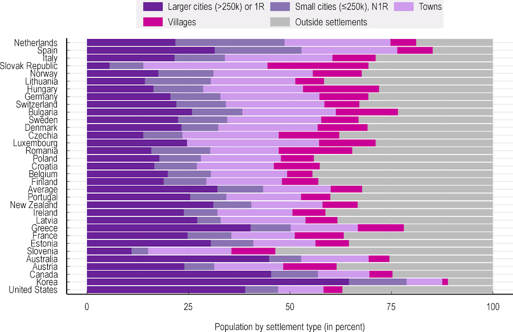
Note: Countries are in descending order according to the share of the population living in mid‑size settlements: the sum of small cities (<250 000), N1R and towns. Luxembourg and Slovenia are the only countries with 1R cities of <250 000 inhabitants.
Source: Based on GEOSTAT (Eurostat, 2011; 2021[18]) data and other population grid data from Annex Table 1.A.3.
Turning to population changes, the largest settlements within these countries led population growth in 2011‑21 (Figure 4.2). Population changes are available for many European countries: all countries in the European Union except Luxembourg (which does not have 2011 data) plus Norway and Switzerland. On average, large and 1R cities grew 0.4% per year over the 10‑year period. In contrast, towns and small N1R cities had average annual growth rates of just over 0.1% in the 2011‑21 period.
Mid‑size settlements exclude the smallest settlements (villages) and the largest ones – both 1R cities (largest in their respective countries) and “large cities” (those with more than 250 000 inhabitants). For the remaining categories – towns and small N1R cities – their median growth rate exceeded their population-weighted means, indicating faster growth in relatively smaller settlements within these categories. Instead, for villages, the median village did not grow, compared to an average population-weighted growth rate of 0.1% per year.
Figure 4.2. Population growth in EU countries, 2011‑21
Population-weighted average (aggregate) and median annual growth rates
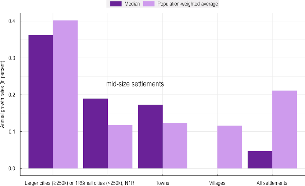
Note: Growth computed as compound annual growth rates for the period 2011‑21. Median values exclude settlements that did not exist in 2011; aggregate growth rate tabulations include such settlements.
Source: Based on GEOSTAT (Eurostat, 2011; 2021[18]) data.
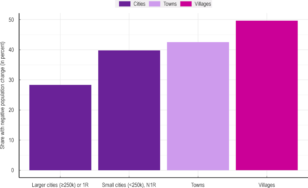
In fact, more than 40% of mid‑size settlements lost population over the last decade. Specifically, half of villages, 40% of small, N1R cities and 43% of towns lost population in the 2011‑21 period, while the share of large and 1R cities with population loss was “only” 28% (Figure 4.3). The finding that smaller settlements show a higher propensity to lose population, especially compared to larger cities, echoes urbanisation trends that have been observed in functional urban areas (Moreno-Monroy, Schiavina and Veneri, 2021[22]) and regions (OECD, 2022[23]).
Figure 4.3 shows the shares of mid‑size settlements with population loss by country. These shares are highest in eastern European countries (e.g. Hungary, Latvia, Lithuania and Poland), where population loss is observed across most types of settlements, which is in line with national trends. However, even some countries with national population growth (e.g. Finland, France, Slovenia, Spain) show considerable population loss in mid‑size settlements. In fact, Poland’s National Urban Policy highlights that mid‑size settlements’ population loss has been coupled with the loss of socio-economic functions and, therefore, needs to be addressed with strategic interventions at the national and regional levels (Polish Government, 2022[24]).
Figure 4.3. Share of EU settlements losing population over the 2011‑21 period
Figure 4.4. Share of mid‑size settlements losing population, by country, 2011‑21
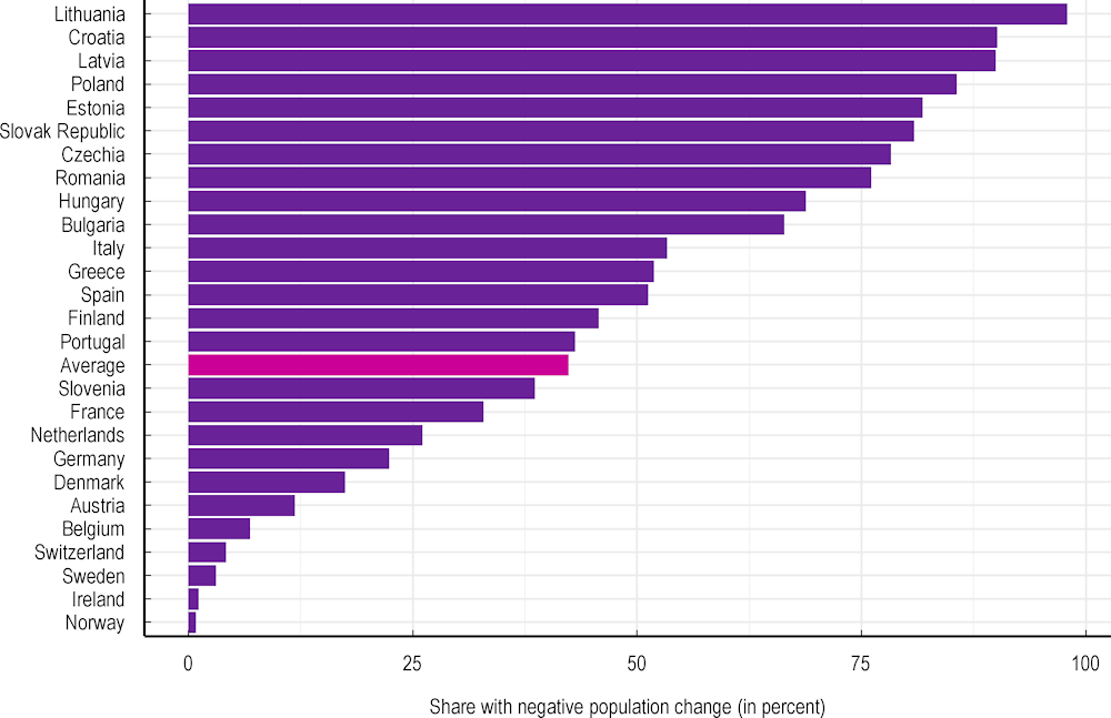
Source: Based on GEOSTAT (Eurostat, 2011; 2021[18]) data of mid‑size settlements – small cities (<250k), N1R and all towns.
Towns close to large cities are growing even faster than cities
Towns and villages close to cities are growing while others are shrinking (Figure 4.5). Towns close to large cities grew approximately 0.5% per year over the last decade. At the same time, villages close to a large city (within a 30-minute drive from the border of a city with 250 000 or more inhabitants) grew even faster, 0.7% per year on average. Large cities themselves also grew over this period, averaging 0.4% population growth per year, roughly 4 times as fast as small N1R cities. In contrast, towns far from cities and villages more than 30 minutes from any city shrank roughly 0.2% per year over the decade.
Figure 4.5. Population changes in EU settlements, by access to a city, 2011‑21
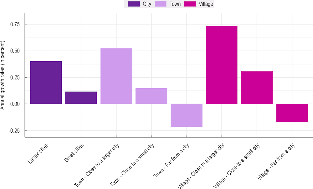
Note: Growth computed as compound annual growth rates for the period 2011‑21. Values exclude settlements that did not exist in 2011.
Source: Based on GEOSTAT (Eurostat, 2011; 2021[18]) data.
Areas around mid‑size settlements are growing too
Urbanisation trends are strong not just within settlements but also in their surrounding areas. This analysis evaluates population changes in the area outside of a settlement, using isochrones to assess the areas within short driving distances. There are several reasons for considering the people living just outside of settlements:
Settlement borders can change over the years. While this analysis holds settlement borders fixed at their 2021 locations and looks at changes from 2011, population density might have increased or decreased in the immediate vicinity of these borders. The expansions, contractions or shifts in settlement borders are key reasons to consider population growth in an area that extends beyond the settlement’s borders.
Residents living just outside the boundaries are likely to access services and amenities within the settlement, and the placement of such residents may reflect the settlement’s functional role in its broader landscape.
How large is the relevant area associated with a given mid‑size settlement? When considering towns and small cities, a 15-minute driving time isochrone appears to be plausibly related to the central settlement. In fact, extending drive time isochrones far beyond 15 minutes increases the probability that it includes other, larger settlements and thus risks double-counting people who are residing in other (especially larger) settlements.
Each light bar in Figure 4.6 represents the average annual population change in a given type of mid‑size settlement (distinguishing between towns close to a city and those with no city within a 30-minute driving distance). Each dark bar represents the annual change in their surrounding 15-minute isochrones. Evidently, the population around mid‑size settlements grew more – or shrank less – than the settlements themselves. In other words, mid‑size settlements had higher average population growth in their surroundings over the past decade compared to those within their borders.
Figure 4.6. Population changes in mid‑size settlements and their 15-minute isochrones, 2011–21
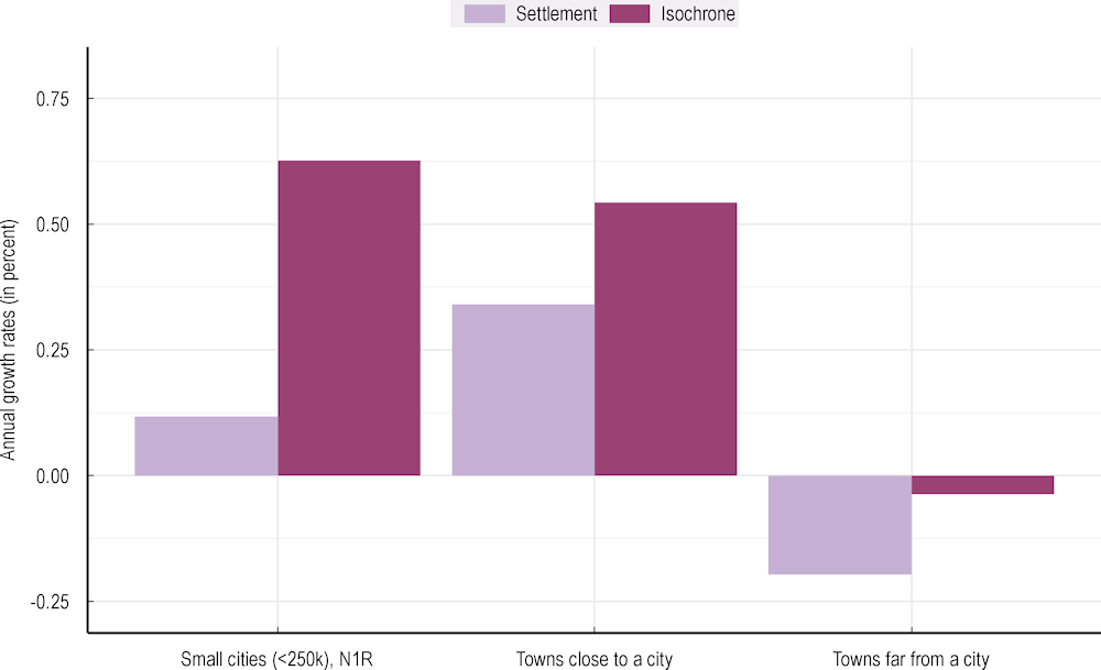
Note: Graph shows mid‑size settlements only. Growth computed as compound annual growth rates.
Source: Based on GEOSTAT (Eurostat, 2011; 2021[18]) data.
Of all mid‑size settlements, small N1R cities’ isochrones experienced the largest growth in population – nearly 0.8% per year, or sixfold the growth inside the settlements’ borders. Towns close to a city had only slightly more population growth in their isochrones than within their borders. Towns far from a city lost around 0.2% of their population per year but, in contrast, their isochrones maintained roughly the same number of residents in 2021 as in the prior decade (Figure 4.6).
Key services and population growth in mid‑size settlements
Since urbanisation trends are strong, mid‑size settlements’ growth patterns depend on the population trends in their local areas. When mid‑size settlements are in relatively rural areas, they play a different role and face different underlying trends (e.g. population decline) than mid‑size settlements in urban areas with stable or positive population growth.
Given trends toward urbanisation, the growth of mid‑size settlements should be compared within relevant local areas. Catchment areas (CAs) are a way of defining relevant comparison groups. They are based on the concept of functional rural areas designed to cover a country’s entire territory (Dijkstra and Jacobs-Crisioni, 2023[25]). Each CA surrounds a single regional centre (RC). The algorithm looks first for the largest settlements within certain areas. Local centres at smaller time horizons are considered first; then, each local centre is tagged as larger or smaller than other settlements nearby until only the 30-minute RCs remain. Afterwards, every grid cell is allocated to the closest RC. This means all other grid cells in a CA are either outside of settlements or in settlements smaller than the RC of reference. The CA approach has been used in other applications: for example, Cattaneo et al. (2024[26]) define CAs for different settlement sizes and travel time thresholds.
Figure 4.7. Catchment area example: Germany
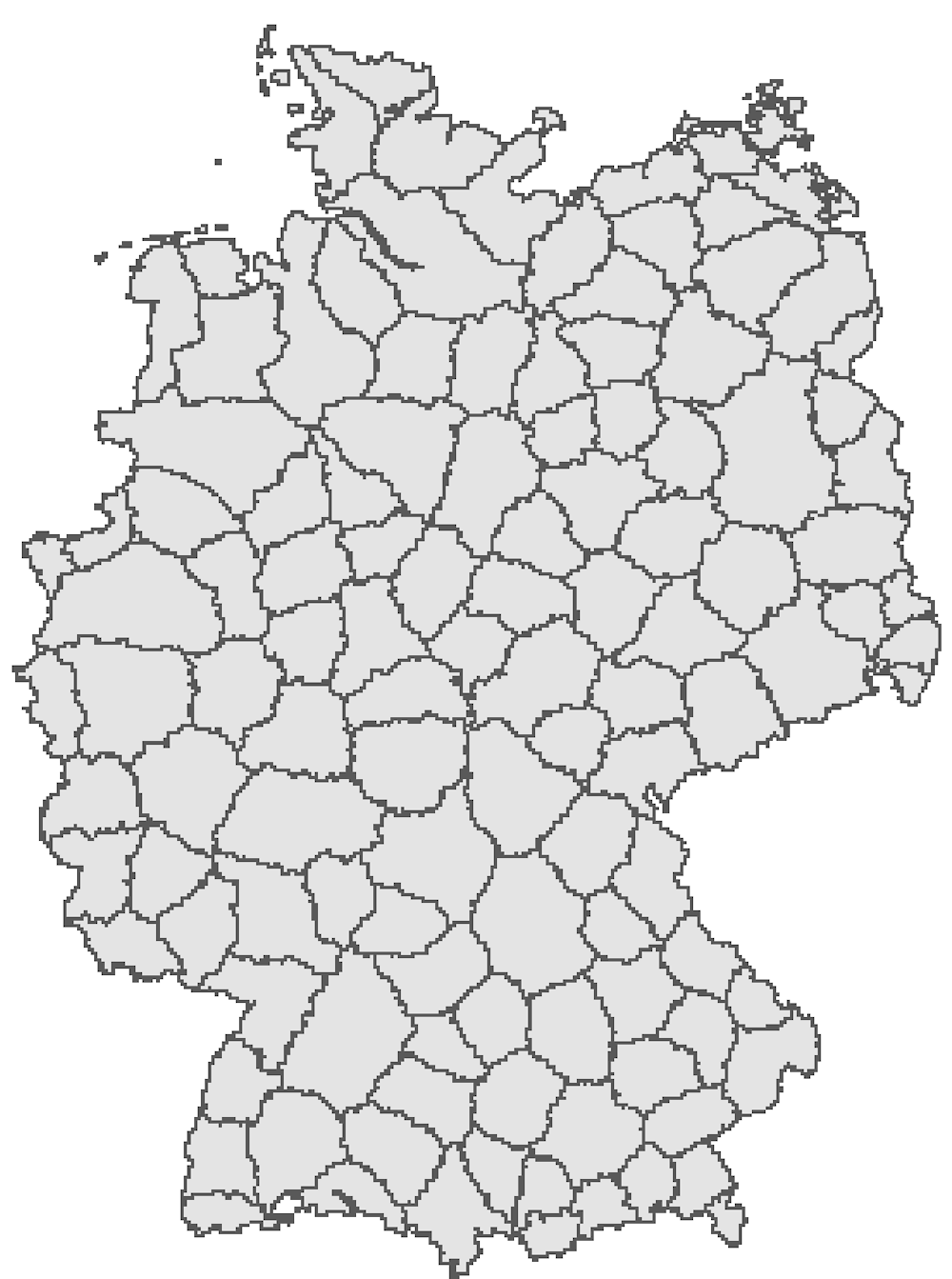
Source: Based on Dijkstra, L. and C. Jacobs-Crisioni (2023[25]), “Developing a definition of Functional Rural Areas in the EU”, European Commission.
This chapter finds that mid‑size settlements close to large cities are growing much faster than those far from cities; yet, as shown in Chapter 2, smaller settlements that are remote tend to have more services than those that are near cities. However, it is possible and even likely that places with higher relative service provision also had higher population growth over the last decade when compared to population growth in their local CAs. Do mid‑size settlements with more services fare relatively better than those with fewer services? This hypothesis is investigated in a regression that looks at the relationship between settlements’ population growth and characteristics, including their services provision and reachability measures (the type of explanatory variables computed in Chapter 2). Measuring the growth rates of mid‑size settlements relative to overall population trends in their nearby CAs is particularly important.
Without the CAs and time-to-city variables, population growth in mid‑size settlements would reflect trends toward urbanisation: mid‑size settlements with more services are those that are more remote and thus more inclined to shrink or grow slowly. Box 4.3 introduces an econometric specification to help disentangle the interaction between population growth on the one hand and reachability and service provision on the other.
Box 4.3. Regression model for population change
The following regression specification aims to capture the interaction between population growth relative to settlements’ reachability and their service provision:
Equation 4.1. Regression model of population change
In the regression specification, is the population growth over the 2011‑21 period in settlement , is an intercept and represents the settlement’s population at the beginning of the period. is a binary variable indicating whether the settlement is a 30-minute RC, indicates travel time to the closest city in minutes of driving and is the idiosyncratic error. The Service vector represents a count variable for common services and binary indicators for uncommon services such as HEIs and hospitals. As elsewhere in the chapter, all tabulations of population changes are based on GEOSTAT (Eurostat, 2011; 2021[18]) gridded population data in EU countries. To control for factors that are common to all settlements in a CAs, catchment fixed effects are included where feasible or, alternatively, the dependent variable is demeaned by population growth in the CAs around settlement . Reachability measures such as RC status and driving time to a city are computed as described in Chapter 1 and services are tabulated from the sources listed in Annex Table 1.A.2.
Mid‑size settlements with more services are growing faster than their surroundings
The regression in Equation 4.1 sheds light on the complex interplay between service provision, geographical factors and population dynamics in mid‑size settlements. The full estimation results are given in Annex Table 4.A.1 and summarised in Table 4.3. The first column shows results for all mid‑size settlements, using CA fixed effects to control for common factors that affect local population growth. The second column shows results for a similar specification using a “demeaned” dependent variable measuring population growth in the settlement relative to (minus) growth in the rest of the CAs.
The results show that the population growth of mid‑size settlements decreases with time to a large city, similar to the patterns of Figure 4.5. Moreover, the presence of food stores, cinemas, doctors and schools is associated with greater population growth in mid‑size settlements compared to their surrounding areas. Despite being far from large cities, mid‑size settlements that are RCs (i.e. the largest settlements within a 30-minute driving time) are growing even more than other mid‑size settlements, controlling for other local factors in their CAs.
In both columns of Table 4.3, the population growth of settlements with more services outpaced that of settlements with fewer services relative to population growth in their CAs (whether based on fixed effects in CAs or demeaned by average population growth in CAs). Mid‑size settlements that are growing faster than their surroundings tend to have more services, and vice versa: those growing less than their surroundings tend to have fewer services. The results show that mid‑size settlements close to cities are growing faster than those far from cities (a negative estimate for “time to a large city”), as expected from the patterns of Figure 4.5. However, it has a low significance in the first column of Table 4.3 because CA fixed effects control for factors related to distance from a city.
Table 4.3. Regression estimates for mid‑size settlement growth
All EU mid‑size settlements (towns and small cities)
|
Variable |
Population growth 2011‑21 |
Demeaned population growth |
|---|---|---|
|
LnPop(2011) |
(–) |
(–) |
|
Reg Centre |
+ |
+ |
|
Time to a large city |
(–), Low significance |
(–) |
|
Cinemas |
+ |
+ |
|
Food stores |
+ |
+ |
|
Schools |
+ |
+ |
|
Doctors |
+ |
+ |
|
Hospitals (indicator) |
(–), Low significance |
(–) |
|
Constant |
+ |
+ |
|
Catchment FEs |
Yes |
No |
|
R2 |
0.271 |
0.096 |
|
N |
8 279 |
8 279 |
Note: Banks and HEIs (indicator) had insignificant estimated coefficients; pharmacies had weakly positive coefficients. (–) indicates statistically significant negative coefficients while + indicates statistically significant positive coefficients.
Another extension of the regression investigates the population growth patterns of mid‑size settlements that are RCs (hereinafter “mid‑size RCs”). Specifically, it looks at whether mid‑size RCs with more services than other mid‑size RCs have more population growth and vice versa for those with fewer services. To do so, the regression uses a restricted sample of settlements – only mid‑size RCs – to estimate the coefficients in Equation 4.1. Each RC is specific to a single CA; therefore, the regression uses a demeaned dependent variable instead of CA fixed effects. Full estimation results are shown in Annex Table 4.A.2 and summarised in Table 4.4.
Table 4.4. Regression estimates for population growth in mid‑size settlements that are RCs
All EU mid‑size settlements that are RCs (towns and small cities), dependent variable: demeaned pop growth, 2011‑21
|
Including small cities |
Only towns |
|
|---|---|---|
|
LnPopulation (in 2011) |
Not significant |
(–), Low significance |
|
Dependent variable: Demeaned population growth 2011–21 |
||
|
Time to a large city |
(–) |
|
|
Time to any city |
(–) |
|
|
HEIs (indicator) |
Not significant |
+, Low significance |
|
Food stores |
+, Low significance |
+, Low significance |
|
Catchment FEs |
No |
No |
|
R2 |
0.48 |
0.435 |
|
N |
1 134 |
865 |
Note: All services except HEIs (indicator) and food stores had insignificant estimated coefficients. (–) indicates statistically significant negative coefficients while + indicates statistically significant positive coefficients.
Although RCs have a higher level of service provision than other similar-sized settlements, the presence of additional services does not seem to be related to their population growth. RCs with more food stores had slightly faster growth, as did RC towns with HEIs. Nonetheless, most service types are not strongly associated with population growth in mid‑size RCs. Thus, idiosyncratic differences in service provision across mid‑size RCs do not appear to be consequential for their growth (Table 4.4).
Conclusions
This chapter developed a dataset that links the growth rates of settlements to their population size, reachability indicators and the number of services provided. Analysis reveals that several characteristics of mid‑size settlements, especially access to larger cities, interact with recent growth rates. Towns with access to a large city have been growing fastest, while many towns far from cities have been shrinking. For cities, larger cities have been growing faster than smaller ones. Population in and around small cities and most types of towns is growing faster in the areas surrounding mid‑size settlements than in the settlements themselves. Finally, reachability (or lack thereof) outweighs service availability in influencing population growth. Mid‑size settlements farther from cities have experienced significantly less growth and, in many cases, population decline despite marginally better local service provision compared to similar-sized settlements with access to a city.
As shown in Chapter 2, the provision of services (measured by the number of service point locations) varies systematically with a settlement’s reachability metrics. For example, uncommon anchor services such as HEIs and hospitals are more prevalent in RCs, even mid‑size ones. Towns close to a city are less likely to have these services, as they tend to provide residential functions while benefitting from the agglomerations of the larger city nearby. Within CAs, the regression analysis in this chapter shows that mid‑size settlements that have more services tend to have more positive population growth. Yet the main findings in this chapter indicate that remoteness matters more than services in determining patterns of population growth over the last decade. Despite a slightly higher provision of local services in mid‑size settlements farther from cities, these settlements have been growing much less (and many have lost population) compared to similar-sized towns close to cities.
Annex 4.A. Estimation results
The full results using all mid‑size settlements to estimate Equation 4.1 are given in Annex Table 4.A.1. The subsequent table, Annex Table 4.A.2 shows estimates for only those mid‑size settlements that are RCs.
Annex Table 4.A.1. Regression coefficient estimates for mid‑size settlement growth
All mid‑size settlements (towns and small cities)
|
Variable |
Population growth 2011‑21 |
Demeaned population growth |
|---|---|---|
|
LnPopulation (in 2011) |
-.161*** |
-.135*** |
|
Regional Centre (RC) |
.0511*** |
.0171*** |
|
Time to a large city |
-.013*** |
-.013*** |
|
Cinemas |
.0093** |
.0057** |
|
Food stores |
.0036*** |
.0027*** |
|
Schools |
.0030*** |
.0027*** |
|
Doctors |
-.005* |
-.006*** |
|
Hospitals (indicator) |
.0012*** |
.0009*** |
|
HEIs (indicator) |
-0.00 |
0.011 |
|
Banks |
0.000 |
0.000 |
|
Pharmacies |
.0047* |
.0036** |
|
Constant |
1.425*** |
1.238*** |
|
Catchment FEs |
Yes |
No |
|
R2 |
0.271 |
0.096 |
|
N |
8 279 |
8 279 |
Note: Based on compound annual growth rates. * p < 0.05. ** p < 0.01. *** p < 0.001.
Annex Table 4.A.2. Regression coefficient estimates for population growth in mid‑size RCs
All mid‑size settlements (towns and small cities) that are RCs, dependent variable: demeaned pop growth, 2011‑21
|
Variable |
Including small cities |
Only towns |
|---|---|---|
|
LnPopulation (in 2011) |
-0.0022 |
-0.0141* |
|
Time to a large city |
-0.0154*** |
|
|
Time to any city |
-0.0142*** |
|
|
HEIs (indicator) |
0.0188 |
0.0252* |
|
Food stores |
0.0004* |
0.0014** |
|
Catchment FEs |
No |
No |
|
R2 |
0.48 |
0.435 |
|
N |
1 134 |
865 |
Note: Based on compound annual growth rates. All services except HEIs (indicator) and food stores had insignificant estimated coefficients.
* p < 0.05. ** p < 0.01. *** p < 0.001.
References
[20] ABS (2024), “Regional population”, Australian Bureau of Statistics, https://www.abs.gov.au/statistics/people/population/regional-population/latest-release#interactive-maps.
[13] BBSR (2023), Laufende Stadtbeobachtung - Raumabgrenzungen. Stadt- und Gemeindetypen in Deutschland, Bundesamt für Bauwesen und Raumordnung, https://www.bbsr.bund.de/BBSR/DE/forschung/raumbeobachtung/Raumabgrenzungen/deutschland/gemeinden/StadtGemeindetyp/StadtGemeindetyp.html.
[10] Bolton, T. and P. Hildreth (2013), Mid-sized Cities: Their Role in England’s Economy, Centre for Cities, https://www.centreforcities.org/publication/mid-sized-cities/.
[4] Burghardt, A. (1971), “A hypothesis about gateway cities”, Annals of the Association of American Geographers, Vol. 61/2, pp. 269-285.
[15] Cardoso, R. and E. Meijers (2017), “Secondary yet metropolitan? The challenges of metropolitan integration for second-tier cities”, Planning Theory and Practice, Vol. 18/4, pp. 616-635, https://doi.org/10.1080/14649357.2017.1371789.
[26] Cattaneo, A. et al. (2024), “Worldwide delineation of multi-tier city-regions”.
[17] Cities Alliance (2019), Connecting Systems of Secondary Cities: How Soft and Hard Infrastructure Can Foster Equitable Economic Growth among Secondary Cities, Cities Alliance/UNOPS, Brussels, https://www.citiesalliance.org/sites/default/files/2019-07/CA_ConnectingSystems_Web_FINAL%20%281%29.pdf.
[25] Dijkstra, L. and C. Jacobs-Crisioni (2023), “Developing a definition of Functional Rural Areas in the EU”, European Commission.
[16] ESPON (2016), “Second tier cities matter”, ESPON Policy Brief, European Observation Network for Territorial Development and Cohesion, https://espon.public.lu/dam-assets/publications/espon-policy-brief-second-tier-cities.pdf.
[18] Eurostat (2011; 2021), GEOSTAT Population Grid, https://ec.europa.eu/eurostat/web/gisco/geodata/population-distribution/geostat.
[11] INSEE (2017), Des villes moyennes marquées par leur diversité fonctionnelle et leur insertion dans un réseau métropolitain, Institut national de la statistique et des études économiques, https://www.insee.fr/fr/statistiques/2840610#documentation.
[22] Moreno-Monroy, A., M. Schiavina and P. Veneri (2021), “Metropolitan areas in the world. Delineation and population trends”, Journal of Urban Economics, Vol. 125, p. 103242, https://doi.org/10.1016/j.jue.2020.103242.
[9] OECD (2022), “Database metadata and release notes. Updated: August, 2022”, OECD Metropolitan Database, OECD, Paris, http://dotstat.oecd.org/?lang=en.
[23] OECD (2022), OECD Regional Outlook.
[2] OECD (2019), OECD Principles on Rural Policy, OECD, Paris, https://web-archive.oecd.org/2019-10-02/531927-Principles%20on%20Rural%20Policy%20Brochure%202019_Final.pdf.
[1] OECD (2019), OECD Principles on Urban Policy, OECD, Paris, https://www.oecd.org/cfe/Brochure-OECD-Principles-Urban-Policy.pdf.
[3] OECD et al. (2021), Applying the Degree of Urbanisation: A Methodological Manual to Define Cities, Towns and Rural Areas for International Comparisons, OECD Regional Development Studies, OECD Publishing, Paris/European Union, Brussels, https://doi.org/10.1787/4bc1c502-en.
[12] ONS (2019), Understanding Towns in England and Wales: An Introduction, Office for National Statistics, United Kingdom, https://www.ons.gov.uk/peoplepopulationandcommunity/populationandmigration/populationestimates/articles/understandingtownsinenglandandwales/anintroduction.
[6] Orum, A., J. Bolay and A. Kern (2019), “Intermediate cities”, in The Wiley Blackwell Encyclopedia of Urban and Regional Studies, Wiley, https://doi.org/10.1002/9781118568446.eurs0163.
[21] Pesaresi, M. et al. (2024), “Advances on the Global Human Settlement Layer by joint assessment of Earth Observation and Population Survey data”.
[24] Polish Government (2022), National Urban Policy 2030, Ministry of Development Funds and Regional Policy.
[8] Powe, N., T. Hart and T. Shaw (eds.) (2007), Market Towns: Roles, Challenges and Prospects, Routledge.
[5] Roberts, B., B. Iglesias and J. Llop (2017), “Intermediary cities: The nexus between the local and the global”, in Co-Creating the Urban Future: The Agenda of Metropolis, Cities and Territories, Global Report on Decentralization and Local Democracy, UCLG, https://www.gold.uclg.org/sites/default/files/GOLDIV_ENG.pdf.
[7] Rodríguez‐Pose, A. and J. Griffiths (2021), “Developing intermediate cities”, Regional Science Policy & Practice, Vol. 13/3, pp. 441-456, https://doi.org/10.1111/rsp3.12421.
[19] Schiavina, M. et al. (2023), GHS-POP R2023A - GHS Population Grid Multitemporal (1975-2030), Joint Research Centre, European Commission, http://data.europa.eu/89h/2ff68a52-5b5b-4a22-8f40-c41da8332cfe.
[14] Van Leynseele, Y. and M. Bontje (2019), “Visionary cities or spaces of uncertainty? Satellite cities and new towns in emerging economies”, International Planning Studies, Vol. 24/3-4, pp. 207-217, https://doi.org/10.1080/13563475.2019.1665270.
Note
← 1. Accessibility refers to the ability to reach destinations using a given transport mode.
