Changes in temperatures and precipitations have led to a notable decrease in soil moisture in many OECD regions.
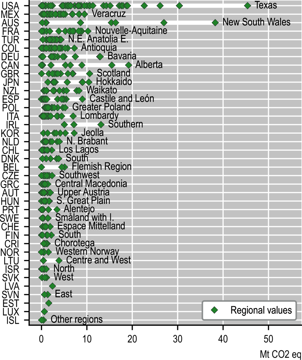
Agriculture accounted for 9% of total production-based emissions in 2018 in OECD countries. While total GHG emissions declined by 6% during the last 2 decades, agriculture emissions increased by 4% over the same period in OECD countries (Crippa et al., 2021). Emissions in this sector mainly reflect methane (CH4, 65%) emitted by animals and rice cultivation and nitrous oxide (N2O, 33%) released from pastures and crops using nitrogen fertilisers. Modelled pathways that limit global warming to 1.5°C above pre-industrial levels involve deep reductions in emissions of methane by 35% or more by 2050 relative to 2010 (IPCC, 2018). One-quarter of OECD regions produce 70% of the emissions from the agriculture sector. New South Wales (Australia) and Iowa and Texas (US) had the highest emissions in agriculture in 2018. These 3 regions treble the emissions of more than 95% of OECD regions. In terms of emissions per unit of GVA, the most emission-intensive regions are Southern Ireland, the region of Canterbury in New Zealand, Wales in the UK and Montana in the US. This corresponds to territorial emissions and does not reflect the carbon footprint of agricultural products and their export to distant locations (Figure 2.25).
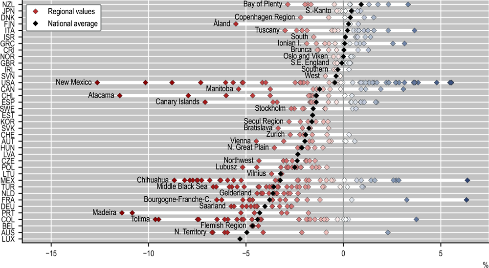
Rising prices of energy and fertilisers, as well as the increasing frequency and intensity of climate hazards, put pressure on the agricultural sector and food security. Increased temperatures and changes in precipitation distribution can lead to droughts, which directly affect agricultural yields. Drought is here measured in terms of percentage change in soil moisture compared to 1981-2010 (reference period). In one-third of OECD regions, croplands’ soil moisture decreased by more than 3% over the past 5 years compared to 1981-2010. Across and within OECD countries, the impact of droughts on agriculture differs widely. Among the most affected regions, Tolima in Colombia and Chihuahua in Mexico experienced a soil moisture decline of about 10% over the past 5 years compared to the reference period. In these 2 regions, GVA in agriculture, forestry and fishing account for a significant share of total GVA (respectively 17% and 7%), which makes the economy of these regions particularly vulnerable (Figure 2.27).
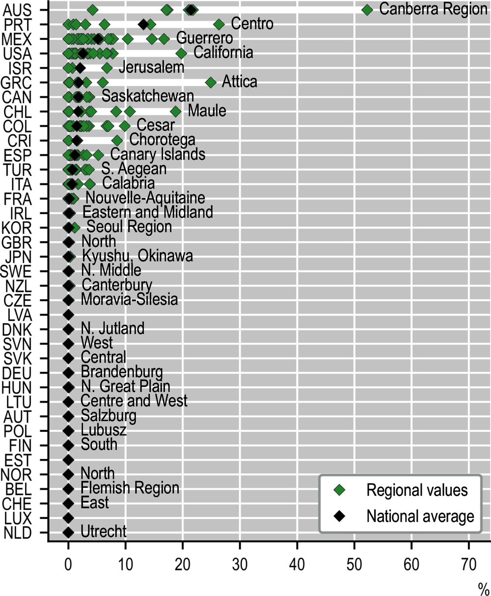
Wildfires have also been affecting agricultural lands and forests. In terms of relative surface, the most impacted regions are the Canberra region (Australia) where 52% of the forest area burned in the past 5 years, followed by Attica in Greece and Central Portugal. In terms of cropland exposure, more than 3% of the croplands were burned in the past 5 years in Australia, Costa Rica, Mexico and Türkiye. In the region of South-eastern Anatolia – Middle (Türkiye), around 20% of the cropland area burned over the past 5 years, corresponding to a total area of 5 500 km2 (Figure 2.26).


